Woore
| Woore | |
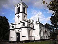 St Leonard's Church, built c. 1830-31 |
|
 Woore |
|
| Population | 1,069 (2011) |
|---|---|
| OS grid reference | SJ730422 |
| Civil parish | Woore |
| Unitary authority | Shropshire |
| Ceremonial county | Shropshire |
| Region | West Midlands |
| Country | England |
| Sovereign state | United Kingdom |
| Post town | CREWE |
| Postcode district | CW3 |
| Dialling code | 01630 |
| Police | West Mercia |
| Fire | Shropshire |
| Ambulance | West Midlands |
| EU Parliament | West Midlands |
| UK Parliament | North Shropshire |
|
|
Coordinates: 52°58′37″N 2°24′07″W / 52.977°N 2.402°W
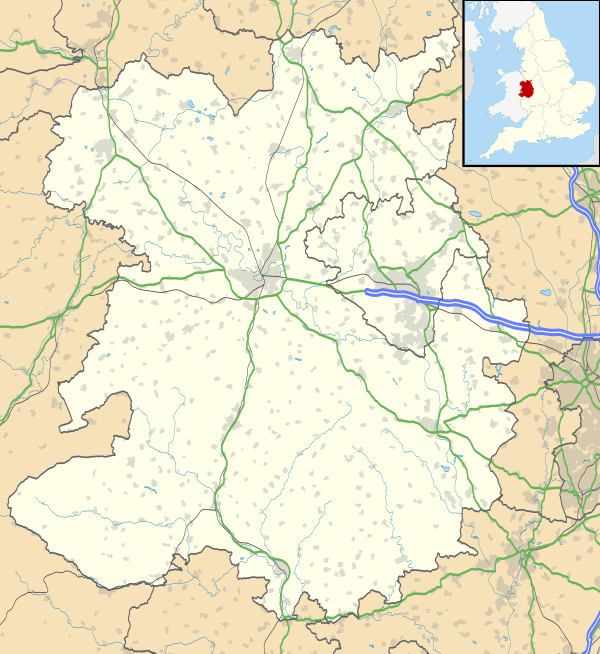
Woore is a village and civil parish in the north east of Shropshire, England. It had a population of 1,411 in the 2001 census, falling to 1,069 at the 2011 Census.[1] The name means "boundary" in ancient Celtic and this fits nicely with the fact that it is on the boundary with both the counties of Cheshire and Staffordshire. The parish is the most northerly in Shropshire.
Location
The civil parish includes several other hamlets and villages including Gravenhunger, Dorrington, Pipe Gate and Ireland's Cross.
The nearest significant towns to Woore are Market Drayton, Whitchurch, Newcastle-under-Lyme, Nantwich and Crewe. The A51 and A525 roads run through the village. The only road links between Woore and the rest of Shropshire pass through adjoining counties. The village is also the farthest place in Shropshire from the centre of the county near Cantlop.
History
Railways
The village was served by the North Staffordshire Railway's Stoke to Market Drayton Line, with a railway station at Pipe Gate (for Woore). Services opened in 1870, but reduced to two trains per day from the mid-1920s. Express Dairies had a creamery with private siding access to Pipe Gate, allowing its preferred transport partner the Great Western Railway to provide milk trains to the facility, for onward scheduling to London via Market Drayton. Passenger services ceased from 1956, and the line was lifted in 1966 after the closure of the creamery, following review under the Beeching Axe.
Racecourse
The village had a National Hunt racecourse until 1963.
Modern day
Bridgemere Garden World is to the north of Woore, just over the border in Cheshire.
The village today is mostly residential with a number of small shops, centred on the Post Office and general stores on the village square. Three public houses service the village, along with one modern red brick primary school and two churches, the smaller of which is a Methodist church, popularly known as "the Chapel on the corner", and the larger of which is St. Leonard's Church of England parish church.
The parish council has 10 elected members, and normally meets monthly.
Woore Cricket Club play at the Falcon Field in the village.[2]
St Leonard's Church
St. Leonard's church was constructed in about 1830-31, to serve what were then five townships of the Shropshire portion of the ancient parish of Mucklestone in Staffordshire, and is of an unconventional white plaster Italianate design, recently (2011) re-painted. It is a Grade II listed buildiong.[3] Designed by George Hamilton of Stone, the bell tower is an Edwardian addition by Chapman and Snape of Newcastle under Lyme. The tower has not been safe to regularly ring in since the late 1980s, with the bells now replaced by a timed recording. The churchyard contains a war grave of a British soldier of World War I.[4]
Notable residents
Locomotive engineer William Bridges Adams, inventor of the Adams axle, was born at Woore in 1797 and brought up there.
Television personality Nick Hancock lives in a £1.1m mansion in Woore.[5]
Notes and references
- ↑ "Civil Parish population 2011". Retrieved 4 December 2015.
- ↑ Woore Cricket Club
- ↑ "Church of Saint Leonard - Woore - Shropshire - England". British Listed Buildings. Retrieved 21 September 2014.
- ↑ CWGC Casualty record.
- ↑ "Don't ban me from the roads.. I'm on TV, Nick Hancock tells Scottish court". Daily Record. 2008-11-13. Retrieved 2008-11-13.
External links
![]() Media related to Woore at Wikimedia Commons
Media related to Woore at Wikimedia Commons
| Unitary authorities | |
|---|---|
| Major settlements | |
| Rivers | |
| Canals | |
| Topics | |