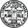
Plainville, Massachusetts
| Plainville, Massachusetts | ||
|---|---|---|
| Town | ||
|
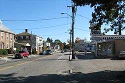
South Street | ||
| ||
| Nickname(s): P-Ville | ||
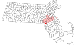 Location in Norfolk County in Massachusetts | ||
| Coordinates: 42°00′15″N 71°20′00″W / 42.00417°N 71.33333°WCoordinates: 42°00′15″N 71°20′00″W / 42.00417°N 71.33333°W | ||
| Country | United States | |
| State | Massachusetts | |
| County | Norfolk | |
| Settled | 1661 | |
| Incorporated | 1905 | |
| Government | ||
| • Type | Open Town Meeting | |
| Area | ||
| • Total | 11.5 sq mi (29.9 km2) | |
| • Land | 11.0 sq mi (28.6 km2) | |
| • Water | 0.5 sq mi (1.3 km2) | |
| Elevation | 250 ft (76 m) | |
| Population (2010) | ||
| • Total | 8,264 | |
| • Density | 749/sq mi (289.0/km2) | |
| Time zone | Eastern (UTC-5) | |
| • Summer (DST) | Eastern (UTC-4) | |
| ZIP code | 02762 | |
| Area code(s) | 508 / 774 | |
| FIPS code | 25-54100 | |
| GNIS feature ID | 0618327 | |
| Website | http://www.plainville.ma.us | |
Plainville is a town in Norfolk County, Massachusetts, United States. The population at the 2010 census was 8,264. Plainville is part of the Providence metropolitan area.[1]
History
Originally included in a 1635 grant of land for Dedham, Massachusetts, the area was later deemed the Plantation of Wollomonuppoag and then later becoming Wrentham, Massachusetts before Plainville branched out as a separate community. Plainville became an officially recognized town in 1905, making it the third youngest town in the state, behind Millville (1916) and East Brookfield (1920).
One of the earliest documentations of Plainville being settled is from 1674, when a Wampanoag man by the name of Matchinamook petitioned and received a few acres of land at the head of the Ten Mile River, at present day Fuller's Dam. As Matchinamook was a native warrior under Wampanoag chieftain Metacomet, or more commonly known in the area as King Philip, he most likely fought during King Philip's War. In its early days, Plainville was nicknamed Slackville after Benjamin Slack, an affluent landowner at the time. After the establishment of a post office in 1856, Plainville became the town name after the abundance of geographical plains in the area. In 1905, Plainville officially separated from Wrentham and became its own town.
Along with bordering North Attleboro, Massachusetts, Plainville shares the Angle Tree Stone, a historic marker dividing the boundaries between the old Massachusetts Bay Colony and Plymouth Bay Colony. This is why the Angle Tree Stone is in the official town seal. Along with many notable veterans, Plainville was the home to George Robert Twelves Hewes, a Revolutionary War veteran who also partook in the Boston Tea Party as well as the Battle of Rhode Island.
Geography
According to the United States Census Bureau, the town has a total area of 11.6 square miles (30 km2), of which 11.1 square miles (29 km2) is land and 0.5 square miles (1.3 km2) (4.24%) is water.
Plainville borders the towns of Wrentham, Foxboro, Mansfield, North Attleboro and Cumberland, Rhode Island. Children and teens living in Plainville attend the A.W. Jackson Elementary School for Kindergarten-3rd grade, then the B.H. Wood School for grades 4-6. Children then attend King Philip Middle School and King Philip Regional High School. Other high school options include the Foxborough Regional Charter School, Tri-County Regional Vocational Technical High School, and Bishop Feehan High School, all in neighboring towns.
Demographics
| Historical population | ||
|---|---|---|
| Year | Pop. | ±% |
| 1910 | 1,385 | — |
| 1920 | 1,365 | −1.4% |
| 1930 | 1,583 | +16.0% |
| 1940 | 1,302 | −17.8% |
| 1950 | 2,088 | +60.4% |
| 1960 | 3,810 | +82.5% |
| 1970 | 4,953 | +30.0% |
| 1980 | 5,857 | +18.3% |
| 1990 | 6,871 | +17.3% |
| 2000 | 7,683 | +11.8% |
| 2010 | 8,264 | +7.6% |
| * = population estimate. Source: United States Census records and Population Estimates Program data.[2][3][4][5][6][7] | ||
As of the census[8] of 2000, there were 7,683 people, 3,009 households, and 2,040 families residing in the town. The population density was 694.6 inhabitants per square mile (268.2/km²). There were 3,111 housing units at an average density of 281.3 per square mile (108.6/km²). The racial makeup of the town was 96.77% White, 0.70% African American, 1.63% Asian, 0.25% from other races, and 0.65% from two or more races. Hispanic or Latino of any race were 0.95% of the population.
There were 3,009 households out of which 33.4% had children under the age of 18 living with them, 56.8% were married couples living together, 7.9% had a female householder with no husband present, and 32.2% were non-families. 26.2% of all households were made up of individuals and 9.1% had someone living alone who was 65 years of age or older. The average household size was 2.53 and the average family size was 3.11.
In the town the population was spread out with 25.5% under the age of 18, 6.2% from 18 to 24, 33.1% from 25 to 44, 23.1% from 45 to 64, and 12.1% who were 65 years of age or older. The median age was 37 years. For every 100 females, there are 97.6 males. For every 100 females age 18 and over, there were 95.4 males.
The median income for a household in the town was $57,155, and the median income for a family was $68,640. Males had a median income of $50,708 versus $32,377 for females. The per capita income for the town was $25,816. About 2.4% of families and 4.0% of the population were below the poverty line, including 3.6% of those under age 18 and 8.5% of those age 65 or over.
Economy
Honey Dew Donuts is based in Plainville. Plainridge Racecourse is granted licensing to become the first slot parlor in the state. With slot machines due to open in 2015. The "racino" will also be the home of Doug Flutie's Sports Bar. Also, 2 Dunkin Donuts, A Panera Bread, Chili's, Target, and a Lowes are located in Plainville. Local Businesses are Boston Tropical Tree, Summer Scoops , Osborne's and Distinctively Sweden. Author Jeff Kinney operated a bookstore in the towns center named An Unlikely Story.
Notable people
- Joseph E Rocco III, Eastern Region LLWS Umpire
- Jim Renner, PGA golfer
- Lofa Tatupu, linebacker for the Seattle Seahawks; raised in Plainville
References
- ↑ "Update of Statistical area Definitions and Guidance on Their Uses" (PDF). whitehouse.gov. pp. 52,108,150. Archived from the original (PDF) on 2007-06-04. Retrieved 2007-06-11.
- ↑ "TOTAL POPULATION (P1), 2010 Census Summary File 1, All County Subdivisions within Massachusetts". United States Census Bureau. Retrieved September 13, 2011.
- ↑ "Massachusetts by Place and County Subdivision - GCT-T1. Population Estimates". United States Census Bureau. Archived from the original on 2012-01-06. Retrieved July 12, 2011.
- ↑ "1990 Census of Population, General Population Characteristics: Massachusetts" (PDF). US Census Bureau. December 1990. Table 76: General Characteristics of Persons, Households, and Families: 1990. 1990 CP-1-23. Retrieved July 12, 2011.
- ↑ "1980 Census of the Population, Number of Inhabitants: Massachusetts". US Census Bureau. December 1981. Table 4. Populations of County Subdivisions: 1960 to 1980. PC80-1-A23. Archived from the original (PDF) on August 5, 2010. Retrieved July 12, 2011.
- ↑ "1950 Census of Population" (PDF). 1: Number of Inhabitants. Bureau of the Census. 1952. Section 6, Pages 21-10 and 21-11, Massachusetts Table 6. Population of Counties by Minor Civil Divisions: 1930 to 1950. Retrieved July 12, 2011.
- ↑ "1920 Census of Population". Bureau of the Census. Number of Inhabitants, by Counties and Minor Civil Divisions. Pages 21-5 through 21-7. Massachusetts Table 2. Population of Counties by Minor Civil Divisions: 1900, 1910, and 1920. Archived from the original (PDF) on August 10, 2010. Retrieved July 12, 2011.
- ↑ "American FactFinder". United States Census Bureau. Archived from the original on 2013-09-11. Retrieved 2008-01-31.
http://digilib.sailsinc.org/plainville/Plainville1930.pdf
External links
| Wikimedia Commons has media related to Plainville, Massachusetts. |
Municipalities and communities of Norfolk County, Massachusetts, United States | ||
|---|---|---|
| Cities | 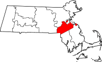 | |
| Towns | ||
| CDPs | ||
| Other village | ||