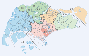
Planning Areas of Singapore
| Planning Areas of Singapore | |
|---|---|
|
Also known as: 新加坡的规划区 (Chinese) Kawasan Perancangan Singapura (Malay) சிங்கப்பூர் திட்ட விரிவாக்கப் பகுதிகள் (Tamil) | |
 | |
| Category | Unitary State |
| Location | Republic of Singapore |
| Created by | Urban Redevelopment Authority |
| Created |
September 1991 (proposed)[1] 22 January 1999 (gazetted)[2] |
| Number | 55 (as of 2014) |
| Populations | 10 (Central Water Catchment and Tengah) – 289,750 (Bedok)[3][4] |
| Areas | 0.77 km2 (0.30 sq mi) (Straits View) – 69.46 km2 (26.82 sq mi) (Western Water Catchment)[4] |
| Government | National Government |
| Subdivisions | Subzone |
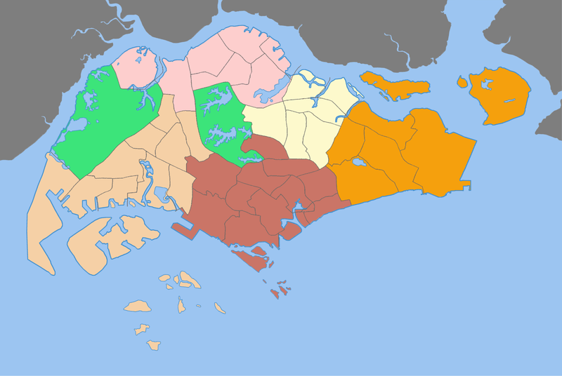
Planning Areas, also known as DGP areas or DGP zones, are the main urban planning and census divisions of Singapore delineated by the Urban Redevelopment Authority. There are a total of 55 of these areas, organised into five regions. A Development Guide Plan is then drawn up for each planning area, providing for detailed planning guidelines for every individual plot of land throughout the country.[2]
The planning areas were first introduced in the early 1990s after the release of the 1991 Concept Plan. Since the implementation of these boundaries, other governmental ministries and departments have also increasingly adopted these boundaries for their administrative purposes. For example, the Statistics Department of Singapore published its 2000 census data based on planning area boundaries for the first time, compared to using census divisions based on electoral boundaries for previous exercises.[5] The Singapore Police Force's (SPF) neighbourhood police centres have jurisdiction boundaries based on planning area boundaries when they were officially gazetted in 1999, as opposed to electoral divisions under the previous neighbourhood Police Post system.
Planning Areas are further subdivided into subzones for statistical purposes.[3][4]
List of Planning Areas
|
| Name (English) | Malay | Chinese | Pinyin | Tamil | Region | Area (km2) | Population | Density (/km2) |
|---|---|---|---|---|---|---|---|---|
| Ang Mo Kio | 宏茂桥 | Hóng mào qiáo | ஆங் மோ கியோ | North-East | 13.94 | 174,770 | 12,538.2 | |
| Bedok | * | 勿洛 | Wù luò | பிடோ | East | 21.69 | 289,750 | 13,360.5 |
| Bishan | 碧山 | Bì shān | பீஷான் | Central | 7.62 | 90,700 | 11,896.6 | |
| Boon Lay | 文礼 | Wén lǐ | பூன் லே | West | 8.23 | 30 | 3.6 | |
| Bukit Batok | * | 武吉巴督 | Wǔjí bā dū | புக்கிட் பாத்தோக் | West | 11.13 | 139,270 | 12,513 |
| Bukit Merah | * | 红山 | Hóng shān | புக்கிட் மேரா | Central | 14.34 | 155,840 | 10,871.3 |
| Bukit Panjang | * | 武吉班让 | Wǔjí bān ràng | பக்கிட் பஞ்சாங் | West | 8.99 | 139,030 | 15,466.7 |
| Bukit Timah | * | 武吉知马 | Wǔjí zhī mǎ | புக்கித் திமா | Central | 17.53 | 74,470 | 4,248.4 |
| Central Water Catchment | Kawasan Tadahan Air Tengah | 中央集水区 | Zhōngyāng jí shuǐ qū | மத்திய நீர் நீர்ப்பிடிப்பு | North | 37.15 | 10 | 0.3 |
| Changi | * | 樟宜 | Zhāng yí | சாங்கி | East | 40.61 | 2,530 | 62.3 |
| Changi Bay | Teluk Changi | 樟宜湾 | Zhāng yí wān | சாங்கி பே | East | 1.7 | ||
| Choa Chu Kang | 蔡厝港 | Cài cuò gǎng | சுவா சூ காங் | West | 6.11 | 174,330 | 28,513.2 | |
| Clementi | 金文泰 | Jīn wéntài | கிளிமெண்டி | West | 9.49 | 91,630 | 9,650.3 | |
| Downtown Core | Pusat Bandar | 市中心 | Shì zhōngxīn | சிங்கப்பூர் நகர மையத்தில் | Central | 4.34 | 3,720 | 857.1 |
| Geylang | * | 芽笼 | Yá lóng | கேலாங் | Central | 9.64 | 116,960 | 12,129 |
| Hougang | 后港 | Hòu gǎng | ஹவ்காங் | North-East | 13.93 | 222,310 | 15,960.2 | |
| Jurong East | Jurong Timur | 裕廊东 | Yù láng dōng | ஜூரோங் கிழக்கு | West | 17.83 | 84,980 | 4,766.9 |
| Jurong West | Jurong Barat | 裕廊西 | Yù láng xī | ஜூரோங் மேற்கு | West | 14.69 | 272,660 | 18,563.5 |
| Kallang | * | 加冷 | Jiā lěng | காலாங் | Central | 9.17 | 101,210 | 11,038.3 |
| Lim Chu Kang | 林厝港 | Lín cuò gǎng | லிம் சூ காங் | North | 17.3 | 90 | 5.2 | |
| Mandai | 万礼 | Wàn lǐ | North | 11.77 | 2,120 | 180.2 | ||
| Marina East | Marina Timur | 滨海东 | Bīnhǎi dōng | மெரினா கிழக்கு | Central | 1.82 | ||
| Marina South | Marina Selatan | 滨海南 | Bīnhǎi nán | மெரினா தென் | Central | 1.62 | ||
| Marine Parade | 马林百列 | Mǎ lín bǎi liè | மரின் பரேட் | Central | 6.12 | 48,730 | 7,966.3 | |
| Museum | Muzium | 博物馆 | Bówùguǎn | அருங்காட்சியகம் திட்டமிடல் பகுதி | Central | 0.83 | 380 | 457.8 |
| Newton | 纽顿 | Niǔ dùn | நியூட்டன் | Central | 2.07 | 6,920 | 3,344.6 | |
| North-Eastern Islands | Kepulauan Timur Laut | 东北群岛 | Dōngběi qúndǎo | வட-கிழக்கு தீவுகள் | North-East | 42.88 | 60 | 1.4 |
| Novena | 诺维娜 | Nuò wéi nà | நொவீணா | Central | 8.98 | 47,990 | 5,344.1 | |
| Orchard | 乌节 | Wū jié | ஓர்ச்சர்ட் | Central | 0.96 | 920 | 960.3 | |
| Outram | 欧南 | Ōu nán | ஊட்ரம் | Central | 1.37 | 22,080 | 16,081.6 | |
| Pasir Ris | * | 巴西立 | Bāxī lì | பாசிர் ரிஸ் | East | 15.02 | 139,890 | 9,313 |
| Paya Lebar | * | 巴耶利峇 | Bā yé lì bā | பாய ளேபர் | East | 11.69 | 40 | 3.4 |
| Pioneer | 先驱 | Xiānqū | பயனியர் | West | 12.1 | 100 | 8.3 | |
| Punggol | 榜鹅 | Bǎng é | பொங்கோல் | North-East | 9.34 | 109,750 | 11,746.8 | |
| Queenstown | 女皇镇 | Nǚhuáng zhèn | குவீன்ஸ்டவுன் | Central | 20.43 | 98,050 | 4,800.5 | |
| River Valley | 里峇峇利 | Lǐ bā bā lì | நதி பள்ளத்தாக்கு | Central | 1.48 | 9,190 | 6,230.5 | |
| Rochor | 梧槽 | Wú cáo | ரோச்சர் | Central | 1.62 | 14,590 | 9,034.1 | |
| Seletar | * | 实里达 | Shí lǐ dá | North-East | 10.25 | 270 | 26.3 | |
| Sembawang | * | 三巴旺 | Sān bā wàng | செம்பவாங் | North | 12.34 | 76,530 | 6,203.3 |
| Sengkang | 盛港 | Shèng gǎng | செங்காங | North-East | 10.59 | 206,680 | 19,511 | |
| Serangoon | * | 实龙岗 | Shí lónggǎng | சிராங்கூன் | North-East | 10.1 | 120,670 | 11,945.2 |
| Simpang | * | 新邦 | Xīn bāng | சிம்பாங் | North | 5.13 | ||
| Singapore River | Sungai Singapura | 新加坡河 | Xīnjiāpō hé | சிங்கப்பூர் நதி | Central | 0.96 | 2,720 | 2,842.2 |
| Southern Islands | Kepulauan Selatan | 南部群岛 | Nánbù qúndǎo | தெற்கு தீவுகள் | Central | 6.07 | 1,480 | 244 |
| Straits View | Pemandangan Selat | 海峡景 | Hǎixiá jǐng | ஸ்ட்ரெய்ட்ஸ் காண்க | Central | 0.77 | ||
| Sungei Kadut | Sungai Kadut | 双溪加株 | Shuāng xī jiā zhū | North | 15.99 | 850 | 53.2 | |
| Tampines | * | 淡滨尼 | Dàn bīn ní | தெம்பினிஸ் | East | 20.89 | 261,230 | 12,506.2 |
| Tanglin | 东陵 | Dōng líng | டங்லின் | Central | 7.63 | 19,000 | 2,491.8 | |
| Tengah | * | 登珈 | Dēng jiā | தெங்கா | West | 7.4 | 10 | 1.4 |
| Toa Payoh | 大巴窑 | Dàbā yáo | தோ பயோ | Central | 8.17 | 124,940 | 15,298.2 | |
| Tuas | 大士 | Dà shì | துவாஸ் | West | 30.04 | 70 | 2.3 | |
| Western Islands | Kepulauan Barat | 西部群岛 | Xībù qúndǎo | மேற்கத்திய தீவுகள் | West | 39.47 | ||
| Western Water Catchment | Kawasan Tadahan Air Barat | 西部集水区 | Xībù jíshuǐqū | மேற்கத்திய நீர் நீர்ப்பிடிப்பு | West | 69.46 | 900 | 13 |
| Woodlands | 兀兰 | Wù lán | ஊட்லண்ட்ஸ் | North | 13.59 | 250,290 | 18,424 | |
| Yishun | 义顺 | Yì shùn | யீஷூன் | North | 21.24 | 201,970 | 9,507.2 |
* = Place names attested to be of Malay origin and referred to similarly in the Malay language.
See also
References
- ↑ "HistorySG - 1991 Concept Plan is unveiled". National Library Board.
- 1 2 "Singapore Infopedia - Development guide plan". National Library Board.
- 1 2 "Singapore Residents by Planning Area/Subzone, Age Group and Sex, June 2000 – 2015" (XLS). Statistics Singapore. Statistics Singapore. Retrieved 7 January 2016.
- 1 2 3 City Population - statistics, maps and charts | SINGAPORE: Subdivision
- ↑ Arumainathan, P. (1970). REPORT ON THE CENSUS OF POPULATION 1970 SINGAPORE - Volume II. Singapore Department of Statistics.