Central Region, Singapore
| Central Region | |||||||
|---|---|---|---|---|---|---|---|
| Region | |||||||
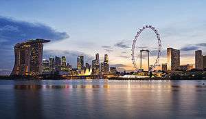
From top left to right: Skyline of the Downtown Core, Bishan-Ang Mo Kio Park, Reflections at Keppel Bay, Fusionopolis at One North, Toa Payoh Town Centre | |||||||
 Planning Areas in the Central Region, excluding PAs within the Central Area | |||||||
| Coordinates: 1°18′2.04″N 103°49′17.97″E / 1.3005667°N 103.8216583°E | |||||||
| Country |
| ||||||
| Planning Areas |
21
| ||||||
| CDC | |||||||
| Regional centre | Central Area (de facto) | ||||||
| Largest PA | Bukit Merah | ||||||
| Government | |||||||
| • Mayors |
Central Singapore CDC North West CDC South East CDC South West CDC | ||||||
| Area[1] | |||||||
| • Total | 132.7 km2 (51.2 sq mi) | ||||||
| Population (2015)[1] | |||||||
| • Total | 939,890 | ||||||
| • Density | 7,100/km2 (18,000/sq mi) | ||||||


.jpg)
The Central Region is one of the five regions in the city-state of Singapore and the main metropolitan region surrounding the Central Area. Comprising 13,150 hectares of land area,[2] it includes 11 planning areas within the Central Area, as well as another 11 more outside it.
Although the Central Area is by nature chiefly commercial, especially the area in the Downtown Core, it also includes 335,400 residential housing units[2] of various types, ranging from HDB flats to more exclusive forms of private housing, such as bungalows, which are a status symbol because land is expensive. There are also 1000 hectares of green spaces, including parks, gardens and other recreational spaces linked by 19 km of park connectors, which were built in order to make this area aesthetically pleasing.
Planning strategies
Planning considerations for the URA Master Plan 2003 involving the Central Region took into consideration its existing strengths. Besides being the undisputed core area for business and entertainment in the city, it contains districts steeped in history, various housing types, and numerous institutions for education and community life. Despite the highly built-up character, it still boasts a rich variety of parks, open spaces, and other recreational areas. It is also well connected to the rest of the city though extensive road and rail connections, plus an international gateway to the world via the Maritime ports.
More can be done to maximise these strengths. The Urban Redevelopment Authority envisages the introduction of more homes of various types to the area, particularly in the Downtown Core which has been overwhelmingly commercial for the past decades. Supporting institutions and transport networks should then be upgraded or introduced to cater to the rising resident population in the area.
In terms of business, the New Downtown@Marina Bay will be developed into a thriving extension of the existing central business district. To encourage greater land use flexibility, new business zones and white zones will be introduced. Business and research activities will be promoted at the new one-north and medical park within the grounds of the Singapore General Hospital at Outram Park.
For recreation, plans were made to further extend park connectors to new and existing parks in the region. New sporting facilities will be introduced, such as the redevelopment of the Kallang Sports Hub. Building conservation will continue to be enforced, and nodes for nidge activities will be provided for the masses. Plans for spaces catering specifically for youth activities near Orchard Road are a case in point.
Planning Areas
- Bishan
- Bukit Merah
- Bukit Timah
- Central Area
- Geylang
- Kallang
- Marine Parade
- Novena
- Queenstown
- Tanglin
- Toa Payoh