Port Phillip
| Port Phillip | |
|---|---|
| Port Phillip Bay | |
|
The Melbourne skyline, seen across Port Phillip. | |
|
Map of the Port Phillip area | |
| Coordinates | 38°09′S 144°52′E / 38.150°S 144.867°ECoordinates: 38°09′S 144°52′E / 38.150°S 144.867°E |
| Type | Saline, Permanent, Natural |
| Primary inflows | Yarra River, Patterson River, Werribee River, Little River, Kororoit Creek |
| Primary outflows | Bass Strait |
| Basin countries | Australia |
| Surface area | 1,930 km2 (750 sq mi) |
| Average depth | 8 m (26 ft) |
| Water volume | 25 km3 (6.0 cu mi) |
| Shore length1 | 264 km (164 mi) |
| Surface elevation | 0 m (0 ft) |
| Islands | Swan Island, Duck Island, Mud Islands |
| Settlements | Melbourne, Geelong, Frankston, Mornington, Queenscliff, Sorrento |
| 1 Shore length is not a well-defined measure. | |


Port Phillip (also commonly referred to as Port Phillip Bay or (locally) just The Bay), is a large bay in southern Victoria, Australia; it is the location of Melbourne. Geographically, the bay covers 1,930 square kilometres (480,000 acres) and the shore stretches roughly 264 km (164 mi). Although it is extremely shallow for its size, most of the bay is navigable. The deepest portion is only 24 metres (79 ft), and half the region is shallower than 8 m (26 ft). The volume of the water in the bay is around 25 cubic kilometres (6.0 cu mi).
Prior to British settlement the area around Port Phillip was divided between the territories of the Wathaurong (to the west), Wurundjeri (north) and Boonwurrung (south and east) Nations. Its waters and coast are home to seals, whales, dolphins, corals, and many kinds of seabirds and migratory waders.
The first British to enter the bay were the crews of HMS Lady Nelson, commanded by John Murray and, ten weeks later, HMS Investigator commanded by Matthew Flinders, in 1802. Subsequent expeditions into the bay took place in 1803 to establish the first settlement in Victoria, near Sorrento, but was abandoned in 1804. Thirty years later, settlers from Tasmania returned to establish Melbourne, now the state's capital city, at the mouth of the Yarra River in 1835 and Geelong at Corio Bay in 1838. Today Port Phillip is the most densely populated catchment in Australia [1] with an estimated 4.5 million people living around the bay; Melbourne's suburbs extend around much of the northern and eastern shorelines, and the city of Geelong sprawls around Corio Bay, in the bay's western arm.
Prehistory
Port Phillip Bay formed between the end of the last Ice Age around 8000 BCE and around 6000 BCE,[2] when the sea-level rose to drown what was then the lower reaches of the Yarra River, vast river plains, wetlands and lakes. The Yarra and other tributaries flowed down what is now the middle of the bay, formed a lake in the southern reaches of the bay, dammed by The Heads, subsequently pouring out into Bass Strait.[3]
The Aboriginal people were in occupation of the area long before the bay was formed, having arrived at least 20,000 years ago and possibly 40,000 years ago. Large piles of semi-fossilised sea-shells known as middens, can still be seen in places around the shoreline, marking the spots where Aboriginal people held feasts. They made a good living from the abundant sea-life, which included penguins and seals. In the cold season they wore possum-skin cloaks and elaborate feathered head-dresses.
A dry period combined with sand bar formation, may have dried the bay out as recently as between 800 BCE and 1000 CE.[4]
British exploration
In 1800, Lieutenant James Grant RN was the first known explorer to pass through Bass Strait from west to east in HMS Lady Nelson. He was also the first to see, and crudely chart, the south coast from Cape Banks in South Australia to Wilsons Promontory in Victoria. Grant gave the name "Governor King's Bay" to the body of water between Cape Otway and Wilsons Promontory, but did not venture in and discover Port Phillip.[5]
The first Britons to discover and enter Port Phillip, were the crew of the Lady Nelson, commanded by John Murray, which entered the bay on 15 February 1802.[6][7] Murray called the bay Port King after the Governor of New South Wales, Philip Gidley King. On 4 September 1805,[8] King formally renamed it Port Phillip, in honour of his predecessor Arthur Phillip.[9]
About ten weeks after Murray, Matthew Flinders RN in HMS Investigator also found and entered the port,[7] unaware Murray had been there. The official history of Nicholas Baudin's explorations in Le Géographe claimed they too had sighted the entrance at that time (30 March 1802) but this is almost certainly a later embellishment or error, being absent from the ship's logs and Baudin's own accounts.[10] As a result of Murray's and Flinders' reports, King sent Lieutenant Charles Robbins in HMS Cumberland to explore Port Phillip fully.[11] One of his party, Charles Grimes, became the first European to walk right round the bay, and thus to discover the mouth of the Yarra, on 2 February 1803.
British settlement

King decided to place a convict settlement at Port Phillip, mainly to stake a claim to southern Australia ahead of the French. On 10 October 1803 a convoy of two ships HMS Calcutta and Ocean led by Captain David Collins carrying 402 people (5 Government officials, 9 officers of marines, 2 drummers, and 39 privates, 5 soldiers' wives and a child, and 307 convicts with 17 convicts' wives and 7 children) entered Port Philip Bay.[12] After some investigation it was decided to establish the settlement at a spot known as Sullivan Bay, very close to where Sorrento now exists. The expedition landed at Sullivan Bay on 17 October 1803, and the first of the "orders" issued by Collins bears that date. On 25 October, the King's birthday, the British flag was hoisted over the tiny settlement and a little salvo of musketry celebrated the royal occasion.[13] On 25 November the first white child was born in Victoria and was baptised on Christmas Day, receiving the name of William James Hobart Thorne. The first marriage took place on 28 November, when a free woman, Hannah Harvey was wedded to convict Richard Garrett.[14] Lack of fresh water and good timber, however, led this, the first attempt at British settlement in Victoria, to be abandoned on 27 January 1804. When Collins left Port Phillip, the 'Calcutta' proceeded to Sydney, and the 'Ocean' to Risdon Cove Tasmania, where they arrived on 15 February 1804.[15] Prior to abandonment, a group of convicts including William Buckley, escaped from the settlement. Buckley later took up residence in a cave near Point Lonsdale on the western side of the bay's entrance, The Rip.
Port Phillip was then left mostly undisturbed until 1835, when settlers from Tasmania led by John Batman and John Pascoe Fawkner (who had been at the Sorrento settlement as a child) established Melbourne on the lower reaches of the Yarra. John Batman encountered William Buckley who then became an important translator in negotiations with the local indigenous tribesmen. In 1838 Geelong was founded, and became the main port serving the growing wool industry of the Western District. For a time Geelong rivalled Melbourne as the leading settlement on the bay, but the Gold Rush which began in 1851 gave Melbourne a decisive edge as the largest town in Victoria.
Growth and development of Melbourne
As Melbourne prospered, its wealthy classes discovered the recreational uses of Port Phillip. Bayside suburbs such as St Kilda and Brighton were established on the east shore of the bay. Later, resorts further south such as Sorrento and Portsea became popular. The more swampy western shores of the bay were not so favoured, and have been used mainly for non-residential purposes such as the Point Cook Royal Australian Air Force base and the Werribee Sewage Farm. In recent decades the population along the western side of the bay has grown more rapidly.
In the 21st century, property along the Port Phillip coastline continues to be highly sought after. Port Phillip continues to be extensively used for recreational pursuits such as swimming, cycling, boating, and fishing. The bay also features a number of historical walks and fauna reserves.[16] The traditional land owners of the area have also been acknowledged at a number of sites.
Geography
Port Phillip lies in southern Victoria, separated from Bass Strait by the Bellarine Peninsula to the southwest and Mornington Peninsula to the southeast. It is the largest bay in Victoria and one of the largest inland bays in Australia. The narrow entrance to the bay, called the Rip, between Point Lonsdale and Point Nepean, features strong tidal streams made turbulent by the uneven contours of the seabed. The best time for small craft to enter the Rip is at slack water. Large ships require expert local guidance to enter and exit, provided by the Port Phillip Sea Pilots. Work has commenced to deepen the channel entrance, to allow newer, larger container ships to access Melbourne's docks.
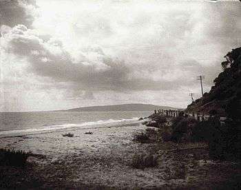
The eastern side of the bay is characterised by sandy beaches extending from St Kilda, Sandringham, Beaumaris, Carrum, and down the Mornington Peninsula to Frankston, Safety Beach/Dromana and Rye to Portsea. Longshore drift carries sand from south to north during winter and from north to south during summer. Cliff erosion control has often resulted in sand starvation, necessitating offshore dredging to replenish the beach. On the western side of the bay there is a greater variety of beach types, including both sandy and sandstone rock beaches, seen at Queenscliff, St Leonards, Indented Head, Portarlington, Altona and Geelong's Eastern Beach. Numerous sandbanks and shoals occur in the southern section of the bay, and parts of the South Channel require occasional maintenance dredging.
Climate
The region has an oceanic climate (Köppen Cfb) with warm summers possessing occasional very hot days due to northerly winds and mild winters. Annual rainfall, which is evenly distributed over the year, shows considerable variation due to the Otway Ranges to the southwest: the northwestern shore of the bay is the driest part of southern Victoria and almost approaches a semi-arid climate (BSk) with a mean annual rainfall as low as 425 millimetres (17 in) (comparable to Nhill or Numurkah), whilst the eastern shores less shielded by the Otways receive as much as 850 millimetres (33 in). Summer temperatures average around 25 °C (77 °F) during the day and 14 °C (57 °F) at night, but occasional northerly winds can push temperatures over 40 °C (104 °F), whilst in winter a typical day will range from 6 °C (43 °F) to 14 °C (57 °F).
Beaches

Port Phillip hosts many beaches, most of which are flat, shallow and long, with very small breaks making swimming quite safe. This attracts many tourists, mostly families, to the beaches of Port Phillip during the summer months and school holidays. Water sports such as body boarding and surfing are difficult or impossible, except in extreme weather conditions. However, stand up paddle boarding (SUP), kite surfing and wind surfing are very popular. Most sandy beaches are located on the bay's northern, eastern and southern shorelines, while the western shorelines host a few sandy beaches, there mostly exists a greater variety of beaches, swampy wetlands and mangroves. The occasional pebble beach and rocky cliffs can also be found, mostly in the southern reaches.
- Major beaches include: St. Kilda Beach, Brighton Beach, Sandringham Beach, Dromana Beach
Rivers and creeks
- Rivers: Yarra River, Maribyrnong River, Patterson River, Little River, Werribee River.
- Creeks: Kananook Creek, Sweetwater Creek, Cowies Creek, Kororoit Creek, Chinamans Creek.
Islands
Due to its shallow depth, numerous artificial islands and forts have been built, however, despite the depth, it only hosts a few true islands. Many sandy, muddy banks and shallows exist in its southern reaches, such as Mud Islands, but most islands are located in the marshy shallows of Swan Bay. Some of the bay's major islands include:
- Swan Island
- Mud Islands
- Duck Island
- South Channel Fort (artificial)
- Pope's Eye (artificial)
Surrounding mountains and hills


- Arthurs Seat 314 m
- Mount Martha 160 m
- Mount Eliza
- Olivers Hill
- Flinders Peak 364 m
Surrounding lakes
- Albert Park Lake
- Cherry Lake
- Lake Borrie
- Lake Carramar, Lake Illawong and Lake Legana of Patterson Lakes
- Lake Connewarre
- Lake Victoria
- RAAF Lake
- Sanctuary Lakes (artificial)
- Salt Lagoon
Ecology

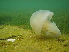
Jellyfish are a familiar sight in Port Phillip, and its waters are home to species such as Australian fur seals, bottlenose dolphins,[17] common dolphins,[17] humpback whales,[17] and southern right whales.[18] Many other cetacean species may also migrate off the areas. The smooth toadfish is one of the most common fishes in muddy areas.[19] The bay has many endemic species including the bluedevil fish and fantastic sponge walls on the Lonsdale wall in the heads of the bay. It also hosts breeding colonies of Australian fur seals. Occasionally, Australian sea lions,[20] New Zealand fur seals, subantarctic fur seals, and leopard seals may come into the bay as well.[21] Certain individual southern elephant seals may frequent the bay as well.[22]
Swan Bay, adjacent to Queenscliff, is an important feeding ground for waterbirds and migratory waders. The Mud Islands, off Sorrento, are an important breeding habitat for white-faced storm petrels, silver gulls, Australian pelicans and Pacific gulls. Salt marshes in the northwestern sections of the bay, such as that in the Werribee Sewage Farm and the adjacent Spit Nature Conservation Reserve, are within the Port Phillip Bay (Western Shoreline) and Bellarine Peninsula Ramsar Site, listed as wetlands of international importance under the Ramsar Convention, and the critically endangered orange-bellied parrot is found at three wintering sites with saltmarsh habitat around Port Phillip and the Bellarine Peninsula. A variety of seabirds, such as Australasian gannets,[23] nest on artificial structures in the bay.
Port Phillip contains 3 Marine Sanctuaries managed by Parks Victoria to protect and conserve the bay's biodiversity, ecological processes and the natural and heritage features.
Original flora and fauna
In 1906, George Gordon McCrae wrote two letters to a local schoolmaster at Dromana, Mr G.H. Rogers. His subject was his earliest recollections of an idyllic boyhood spent at Arthur's Seat Run, location of the historic McCrae Homestead on the southern shore of the bay, part of the Mornington Peninsula. In the letters he described in detail the natural history of the area in the 1840s, and the species he particularly remembered 60 years later. In 1939, Charles Daley read an article before the Victorian Historical Society based on these letters, which was published in their magazine in 1940 the year after a large bushfire in January 1939 hastened the disappearance of much of the original surviving wildlife from the area. The names of the species reflect the titles given to them by the original British settlers of the bay.[24]
The animals he observed as a young boy were "immense droves of kangaroos, brush kangaroos or wallaby, paddy-melon, bandicoots (two varieties), great opossum (two varieties), ring tail, flying squirrel, flying mouse, dingoes or wild dogs in the gullies, that were caught in box traps with sliding doors, porcupine ant eater or echidna that were at the back of Arthur's Seat mountain, the great iguana, tree lizard- 5 feet, python, and the rock or sleeping lizard."
The trees were coast banksia, honey suckle, and grass trees "with crowns for thatching". The gum of Xanthorrhoea australis was used for carriage varnish.
In the waters of the bay he described "scallop shells which were used as an oil lamp with a bulrush wick, banks of cockles covered with birds, grey and white gulls, a 13-16 lb size schnapper ground off Mt Martha Point, mutton fish or venus ear- bait, coatfish, parrot fish, leather jackets, flathead, dog fish, sting rays, shark tailed rays, and pig fish (Castracion) "that he thought to be "very old."
On the beaches could be sighted pelicans, penguins, grey and grey white gull, called "bungan" by aborigines (the Bunurong Mayone-bulluk clan), small white and lavender gull, pied oyster catchers, terns, cormorants, the little sandpiper, and musk ducks.
In the swamps (which have since been filled in) were "The Nankeen bird with one long white feather behind the ear, The rail, The bittern, The snipe and jack snipe, Several ducks- wood duck, black duck, Teal, Spoonbill, Black swan Geese, Cranes, Blue and white coots, Water hens, Kingfishers here and there and swamp or ground parrot with the barred tail feathers."
In the scrub by the waterholes were "honey eaters, warblers, red coat robins, emu wren with 2 long feathers in tail, Laughing jack ass- everywhere, utcher bird, also known as shrike or whistling jackass, Quail where coverage good in bottom of scrub, turkey at Boneo and the big swamp off the property."
On the flats were found spur wing plovers, minas, and leatherheads.
In timbers near the flats were "many varieties of parrots, Lorry, Rosella, Blue mountain or honeysuckle parrot, Sulphur –crested white cockatoo, Black cockatoo of two kinds, Grey cockatoo with scarlet crest and Corella or cockatoo parrot."
Among the cherry trees in the garden at the homestead were "bronzewing pigeon and satin birds, love birds and honeyeating parakeets."
Birds of prey were "eagle hawks, falcons, and owls, some white and of great size".
Cetaceans
.jpg)
Small numbers of common dolphins have become residents in eastern parts of the bay since the late 2000s.[25] In recent years, the numbers of southern humpback and southern right whales entering the bay of Port Phillip have shown increases.[26] Unlike in Portland and on Great Ocean Road, Southern Rights in eastern Victorian waters are still critically endangered[18] and in very small numbers; however, presences of cow-calf pairs in the bay in recent years indicate that Port Phillip Bay was possibly once a wintering/calving ground for these whales.[27][28] They swim very close to shores to take rests in shallow, sheltered waters, sometimes just next to piers in Frankston.[29]
Burrunan dolphins
The bay is home to about 100 to 150 of the recently described species of bottlenose dolphin, the Burrunan dolphin (Tursiops australis). The other 50 or so of this rare species are to be found in the Gippsland Lakes.[30]
Environmental issues
Like the Yarra which flows into it, Port Phillip faces the environmental concerns of pollution and water quality. Litter, silt and toxins can affect the beaches to the point where they are shut down by the EPA.[31]
In 2008, the owner and master of Hong Kong-registered container vessel MV Sky Lucky were found liable for illegally disposing garbage into Port Phillip, convicted and fined $35,000.[32]
Shipping
History


The southern section of the Bay near the Heads is covered by extensive sand banks, known as the "Great Sand". A shipping channel was dredged in an east-west direction from the Heads to near Arthur's Seat late in the nineteenth century, and maintained ever since. Early shipping used piers at Sandridge (Port Melbourne), but later moved to various wharves along the Yarra River, which make up today's Port of Melbourne.[33] The Melbourne Harbor Trust and Geelong Harbor Trust were responsible for the piers and wharves in their respective cities — they are now the government owned Port of Melbourne Corporation and the privately operated GeelongPort.
Today, the Port of Melbourne has grown to become Australia's busiest commercial port, serving Australia's second largest city and handling an enormous amount of imports and exports into and out of the country. The Port of Geelong also handles a large volume of dry bulk and oil, while nearby Port of Hastings on Western Port handles steel and oil products.
In 2004 the Victorian Government launched the Port Phillip Channel Deepening Project to deepen the existing shipping channels and the lower Yarra to accommodate deeper draft vessels. The lower Yarra sediments were identified as likely to be contaminated with toxic chemicals and heavy metals, and were to be contained within a sealed berm clear of the shipping channels south of the Yarra entrance. The vessel chosen for the dredging is the Queen of the Netherlands. 52 environmental groups, recreational fishing groups, and divers' groups formed the "Blue Wedges" group to oppose the proposed channel deepening and dredging with organised protests carried out, culminating in the group taking action in the Federal Court in January 2008 against the Commonwealth to stop it signing off on the project.[34] On 15 January 2008 it was announced that their appeal was dismissed,[35] with dredging starting soon after. The government announced the completion of works in November 2009, ahead of schedule and $200 million under budget.[36]
Shipping channels
- South Channel – Extends from the area of the rip in an easterly direction where it terminates off the coast of Arthurs Seat. Vessels with a draught of 14.0m can be navigated through the channel at all tides. This is the main commercial shipping channel in the south of the bay allowing large ships access between the entrance of the bay and its middle regions.
- West Channel – Extends from the area of the rip, heads towards the north-west and ends off the coast of St Leonards. The depth varies, in May 1998 there was a minimum of 4.1 metres. Non-commercial vessels are still navigated through the channel, however it is no longer used for commercial shipping.
- The Rip – Also referred to as "the heads" for shipping purposes, vessels with a draught of 14.0m can be navigated through the Heads during any height of tide. However, the passage of vessels can be restricted when the current through the rip is too strong. The flow through the Rip can be up to 8 knots dependent on the range of tide and environmental conditions.
- Melbourne Channels – Extends northwards through Hobsons Bay towards Station Pier and the entrance to the Yarra River. It is dredged to a depth of 15.5 metres and is the main shipping channel through the north of the bay into Melbourne's ports and docks. The channels include:
- Melbourne Channel
- Williamstown Channel
- Port Melbourne Channel
- Geelong Channels – Begins off the coast of Point Richards and runs in a westerly direction through Outer Harbour and into Corio Bay where it splits in two heading north towards the modern Port of Geelong and south towards Cunningham Pier. The main Geelong channels are dredged to 12.3m. The City Channel while once used for wool exports is no longer used for commercial shipping. The channels include:
- Point Richards Shipping Channel
- Wilson Spit Shipping Channel
- Hopetoun Shipping Channel
- City Channel
- Corio Channel
Shipping and cargo docks
- Bulk Grain Pier
- Corio Quay
- Cunningham Pier
- Gellibrand Pier
- Lascelles Wharf
- Point Henry Pier
- Point Wilson Pier
- Princes Pier
- Refinery Pier
- Station Pier
- Webb Dock
Ferries
Peninsula Searoad Transport operates a vehicular ferry service across the mouth of the bay between Queenscliff and Sorrento using two roll-on roll-off vessels. Ferries also run from St Kilda to Williamstown, Victoria across Hobsons Bay. These ferries, like the many recreational cruises, mostly operate for tourists and run around the bay in various locations.
- Spirit of Tasmania Ferry (passenger and vehicles)
- Between: Station Pier, Port Melbourne
- And: Devonport, Tasmania
- Searoad Ferries (passenger and vehicles)
- Between: Sorrento Pier, Sorrento
- And: The Cut Pier, Queenscliff
Other features
Flagship
- Enterprize (1997) – Is Melbourne's Flagship, a replica of the Enterprize (1830), the tall ship that brought the first European settlers to Melbourne. She sails around Port Phillip Bay throughout the year, visiting ports at Geelong, Williamstown, Portarlington, Rye and Blairgowrie.
Lighthouses
|
|
|
|
Major marinas and piers
|
|
|
Life saving clubs
|
|
|
|
Yacht clubs
|
Shipwrecks
Some of the more significant and historical shipwrecks in the bay include;
- Mountain Maid – sunk off Swan Island after a collision with the SS Queen (1856)
- Wauchope – sunk off the coast of Sorrento (1918)
- Ozone – scuttled off Indented Head (1925)
- HMVS Cerberus – scuttled in Half Moon Bay, Black Rock (1926)
- HMAS J3 – scuttled in Swan Bay (1926)
- HMAS J7 – scuttled off Hampton Beach (1926)
- ELIZA Ramsden
Marine Sanctuaries
- Point Cooke Marine Sanctuary - features basalt reefs that support many diverse communities of algae, invertebrates and fish species.
- Jawbone Marine Sanctuary - supports several habitats including rocky basalt reef, seagrass beds, saltmarsh and the largest occurrence of mangroves in Port Phillip.
- Ricketts Point Marine Sanctuary - has sandstone rock platforms extending from the shore, creating a diverse marine environment.
Tourism
The bay is one of Victoria's most popular tourist destinations. Many residents of Melbourne holiday on the shorelines of the bay, particularly the Bellarine (South west, near Geelong) and Mornington (south east of Melbourne) Peninsulas, most annually, either camping in tents, caravan or villas in caravan parks, sharing rental houses or staying in holiday homes.
Recreation and sport

Port Phillip's mostly flat topography and moderate waves make perfect conditions for recreational swimming, kitesurfing, windsurfing, sailing, boating, snorkeling, scuba diving, stand up paddle boarding (SUP) and other sports.
Port Phillip is home to 36 Yacht clubs. It also hosts the Melbourne to Hobart and Melbourne to Launceston Yacht Races. Port Phillip is also home to a number of marinas, including large marinas at St Kilda, Geelong and Brighton. For the 1956 Summer Olympics, it hosted the sailing events.[38]
Dozens of lifesaving clubs dot Port Phillip, especially on the east coast from Altona to Frankston. These clubs provide volunteer lifesaving services and conduct sporting carnivals.
Port Phillip is also known as a temperate water scuba diving destination. The shore dives from beaches and piers around the Bay provide a wide variety of experiences on day and night dives. Boat diving in Port Phillip provides access to a remarkable variety of diving environments including wrecks, reefs, drift dives, scallop dives, seal dives and wall dives. Of particular interest are the five scuttled J-Class World War 1 submarines and the Ships' Graveyard off Torquay. With 3 Marine Sanctuaries and easily accessible piers, Port Phillip is also popular for recreational snorkeling.
There are also a number of bike paths, including the Bayside Trail and the Hobsons Bay Coastal Trail.

See also
References
- ↑ "Parks Victoria".
- ↑ Bowler, J.M. "Port Phillip Survey 1957-1963: The Geology & Geomorphology" (PDF). MEMOIRS of the NATIONAL MUSEUM OF VICTORIA MELBOURNE, No. 27 Issued, 1966. NATIONAL MUSEUM OF VICTORIA. Retrieved 13 September 2013.
- ↑ "Taylor & Francis Online :: Marine geology of Port Phillip, Victoria — Australian Journal of Earth Sciences — Volume 48, Issue 3". Informaworld.com. 1-08. Retrieved 16 May 2012. Check date values in:
|date=(help) - ↑ Gary, Stuart. "Port Phillip Bay once high and dry". news in Science. Australian Broadcasting Commission. Retrieved 13 September 2013.
- ↑ Lee, Ida (Mrs. Charles Bruce Marriott) (1915), The Logbooks of the 'Lady Nelson' with the Journal of Her First Commander Lieutenant James Grant, London: Grafton and Company, p. , OL 6580132M
- ↑ Lee 1915, pp. 134–149
- 1 2 Norman Houghton – 'The Story of Geelong'
- ↑ "MEMORABLE INCIDENTS IN AUSTRALIAN.". The Sydney Morning Herald. National Library of Australia. 6 October 1857. p. 2. Retrieved 13 December 2012.
- ↑ Port Phillip Conservation Council: Excerpts from the 'Port Phillip Survey 1957-1963'
- ↑
- ↑ Fleming, James (2002), Currey, John, ed., A journal of Grimes' survey : the Cumberland in Port Phillip January-February 1803, Malvern, Victoria: Banks Society Publications, p. 43, ISBN 0-949586-10-2
- ↑ "CORRESPONDENCE.". The Advertiser. Adelaide: National Library of Australia. 14 October 1901. p. 7. Retrieved 17 January 2012.
- ↑ "Buckley, Wild White Man, Lived with Blacks.". The Queenslander. National Library of Australia. 18 March 1937. p. 3. Retrieved 17 January 2012.
- ↑ "HISTORY OF THE Mornington Peninsula.". Mornington Standard. Vic.: National Library of Australia. 12 August 1905. p. 5 Edition: MORNING. Retrieved 17 January 2012.
- ↑ "RISDON COVE, FIRST LANDING PLACE.". The Mercury. Hobart, Tas.: National Library of Australia. 12 September 1903. p. 1 Supplement: Centenary of Tasmania. Retrieved 17 January 2012.
- ↑ Parks Victoria. "Port Phillip". Retrieved 20 December 2009.
- 1 2 3 "Jason Gedamke, "Australia. Progress report on cetacean research, January 2006 to December 2006, with statistical data for the calendar year 2006."" (PDF). Retrieved 16 May 2012.
- 1 2 Fitzgerald E., Jefferies R., 2011 Southern Right Whale – Eubalaena australis. Taxonomic Toolkit for marine life of Port Phillip Bay. Museum Victoria. Retrieved on 20 June 2014
- ↑ Melbourne's Wildlife (Museum Victoria, 2006), 324.
- ↑ Port Phillip Baykeeper 2011 Stray sea lion lobs in Brighton. Retrieved on 20 June 2014
- ↑ Fitzgerald E., Jefferies R., 2011. Class – Otariidae. Taxonomic Toolkit for marine life of Port Phillip Bay, Museum Victoria. Retrieved on 20 June 2014
- ↑ Edwards Lorna. 2006. Seal's death prompts wildlife protection call. The Age. Retrieved on 20 June 2014
- ↑ T. M. Pyk, A. Bunce, and F. I. Norman, "The influence of age on reproductive success and diet in Australasian gannets (Morus serrator) breeding at Pope's Eye, Port Phillip Bay, Victoria", Australian Journal of Zoology, Vol. 55 No. 5, 2007, pp. 267–274.
- ↑ Daley, Charles. 'Arthur's Seat in the 'forties [1840s]: from letters of George Gordon McCrae' Vol. 18 Issue: 71 p/pp 57-64 1940 http://210.15.209.254/dbtw-wpd/exec/dbtwpub.dll
- ↑ The Dolphin Research Institute, Our Dolphins are Unique. Retrieved on 20 June 2014
- ↑ Fowles S., 2012 Spectators have a whale of a time. Apollos View Accommodation. Retrieved on 20 June 2014
- ↑ January 2014 – Southern Right Whales. ABC News. Retrieved on 20 June 2014
- ↑ http://www.swifft.net.au/cb_pages/southern_right_whale.php
- ↑ Minear T., 2014 Whale spotted swimming close to shore in Port Phillip Bay off Bonbeach, Chelsea and Aspendale. Herald Sun. Retrieved on 20 June 2014
- ↑ Researcher discovers new dolphin species in Victoria, Monash University, 15 September 2011.
- ↑ Ryan, Kellie. Summer deluges leave Port Phillip Bay filthy. Herald Sun. 9 January 2012
- ↑ http://epanote2.epa.vic.gov.au/EPA/publications.nsf/2f1c2625731746aa4a256ce90001cbb5/58f1a95bb5f860a4ca2574fc007c64bb/$FILE/1253.pdf
- ↑ "History of the port". www.portofmelbourne.com. Retrieved 8 November 2009.
- ↑ The Age Newspaper,Court threat to channel deepening
- ↑ The Age Newspaper,Bay dredge gets go-ahead
- ↑ Dowling, Jason (26 November 2009). "Labor hails dredging success, says bay is clean". The Age. theage.com.au. Retrieved 27 November 2009.
- ↑ "The Eastern Lighthouse at McCrae". Lighthouse.net.au. Retrieved 31 December 2012.
- ↑ 1956 Summer Olympics official report. pp. 46-7.
External links
 "Port Phillip". Encyclopædia Britannica. 22 (11th ed.). 1911.
- Large-scale map of Port Phillip showing beaches and recreational facilities
- Port Phillip Sea Pilots
- Shipwreck Info at Heritage Victoria
|
Waterways of the Greater Melbourne catchment, Victoria, Australia | |
|---|---|
| Ocean inlets, harbours and bays | |
| Rivers | |
| Creeks |
|
| Lagoons and lakes | |
| Adjoining rivers and bays | |
| |
