Potlatch, Idaho
| Potlatch, Idaho | |
|---|---|
| City | |
 Location in Latah County and the state of Idaho | |
| Coordinates: 46°55′18″N 116°53′54″W / 46.92167°N 116.89833°WCoordinates: 46°55′18″N 116°53′54″W / 46.92167°N 116.89833°W | |
| Country | United States |
| State | Idaho |
| County | Latah |
| Area[1] | |
| • Total | 0.43 sq mi (1.11 km2) |
| • Land | 0.43 sq mi (1.11 km2) |
| • Water | 0 sq mi (0 km2) |
| Elevation | 2,546 ft (776 m) |
| Population (2010)[2] | |
| • Total | 804 |
| • Estimate (2012[3]) | 812 |
| • Density | 1,869.8/sq mi (721.9/km2) |
| Time zone | Pacific (PST) (UTC-8) |
| • Summer (DST) | PDT (UTC-7) |
| ZIP code | 83855 |
| Area code(s) | 208 |
| FIPS code | 16-64900 |
| GNIS feature ID | 0397063 |
| Website | City of Potlatch |
Potlatch is a city in Latah County, Idaho, United States, located about 6 miles (9.7 km) east of the Idaho-Washington state border, in the north central part of the state. It is along State Highway 6, bordered on the northeast by the small community of Onaway. The population was 804 at the 2010 census.
History
Company town
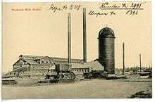
Potlatch was founded in 1905 as a company town by the Potlatch Corporation.[4] The townsite was chosen because of proximity to Potlatch Corporation's large holdings of Western White Pine on the Palouse River. Potlatch was chosen as the mill site. When the mill was built, it was one of the largest sawmills in the US and was the largest white pine sawmill in the world.
Most of Potlatch was built in 1906 and 1907. A total of 143 houses were built in 1906, with 58 more built the following year; other building constructed during that period include boarding houses, an ice house, a Catholic church, hotel, school, and general store.[5]
The company developed and ran Potlatch on a model mostly patterned after that used by Pullman Company for its company town in Illinois.[5] It provide police and fire protection, a school, churches, a hospital, an inexpensive company store, and recreational amenities. It banned prostitution, prohibited alcohol, and encouraged its workers to marry by allowing only married couples to rent the houses it owned.[5] The paternalism was profitable, even though rents were low: during 1943 the company showed a profit of $59,000 for its "townsite" services.[5] Less than a decade later, with labor costs significantly reducing its townsite profit, the mill sold most of the homes and other buildings it owned, and Potlatch was incorporated.[5]
Following the mill's closure
In 1981 the mill was shut down, shortly after the town was sold to the residents.[4] Five years later, part of the town's commercial district, was listed on the National Register of Historic Places.[5]
After the mill's closure, Potlatch became a bedroom community for the university towns of Moscow and Pullman, Washington.[6]
Business and political leaders of Potlatch are making a concerted effort to attract companies involved in the firearms industry; they have set aside 26 acres (11 ha) for such businesses, located on the former site of the mill.[7]
Geography
According to the United States Census Bureau, the city has a total area of 0.43 square miles (1.11 km2), all of it land.[1] Potlatch is north of the confluence of Rock Creek and the Palouse River,[5] on the edge of the Palouse ecoregion.
Climate
Potlatch has a warm-summer Mediterranean climate (Csb) according to the Köppen climate classification system, although its winter months nearly qualify it as having a dry-summer humid continental climate (Dsb).
| Climate data for Potlatch (1915-2012) | |||||||||||||
|---|---|---|---|---|---|---|---|---|---|---|---|---|---|
| Month | Jan | Feb | Mar | Apr | May | Jun | Jul | Aug | Sep | Oct | Nov | Dec | Year |
| Record high °F (°C) | 59 (15) |
65 (18) |
75 (24) |
90 (32) |
95 (35) |
101 (38) |
104 (40) |
110 (43) |
101 (38) |
90 (32) |
71 (22) |
65 (18) |
110 (43) |
| Average high °F (°C) | 35.9 (2.2) |
41.6 (5.3) |
48.1 (8.9) |
57.1 (13.9) |
66 (19) |
72.7 (22.6) |
82.8 (28.2) |
83 (28) |
73.4 (23) |
60.4 (15.8) |
45.2 (7.3) |
37.2 (2.9) |
58.6 (14.8) |
| Average low °F (°C) | 21.1 (−6.1) |
24.8 (−4) |
28.3 (−2.1) |
32.8 (0.4) |
37.9 (3.3) |
43.1 (6.2) |
45.8 (7.7) |
44.3 (6.8) |
38.9 (3.8) |
33.1 (0.6) |
28.6 (−1.9) |
23.1 (−4.9) |
33.5 (0.8) |
| Record low °F (°C) | −36 (−38) |
−32 (−36) |
−13 (−25) |
15 (−9) |
18 (−8) |
25 (−4) |
27 (−3) |
25 (−4) |
14 (−10) |
9 (−13) |
−20 (−29) |
−48 (−44) |
−48 (−44) |
| Average precipitation inches (mm) | 2.84 (72.1) |
2.39 (60.7) |
2.38 (60.5) |
2.02 (51.3) |
2.12 (53.8) |
1.88 (47.8) |
0.8 (20) |
0.79 (20.1) |
1.3 (33) |
1.9 (48) |
2.94 (74.7) |
3.11 (79) |
24.48 (621.8) |
| Average snowfall inches (cm) | 15.1 (38.4) |
7.8 (19.8) |
4.5 (11.4) |
1.2 (3) |
0.1 (0.3) |
0 (0) |
0 (0) |
0 (0) |
0 (0) |
0.3 (0.8) |
4.9 (12.4) |
11.4 (29) |
45.3 (115.1) |
| Average precipitation days | 13 | 11 | 11 | 10 | 9 | 7 | 4 | 4 | 5 | 8 | 12 | 12 | 106 |
| Source: WRCC[8] | |||||||||||||
Demographics
In August 1906 the town had a population of about 1,000; and a year later, it reached around 1,500.[5]
| Historical population | |||
|---|---|---|---|
| Census | Pop. | %± | |
| 1960 | 880 | — | |
| 1970 | 871 | −1.0% | |
| 1980 | 819 | −6.0% | |
| 1990 | 790 | −3.5% | |
| 2000 | 791 | 0.1% | |
| 2010 | 804 | 1.6% | |
| Est. 2015 | 805 | [9] | 0.1% |
2010 census
As of the census[2] of 2010, there were 804 people, 339 households, and 218 families residing in the city. The population density was 1,869.8 inhabitants per square mile (721.9/km2). There were 368 housing units at an average density of 855.8 per square mile (330.4/km2). The racial makeup of the city was 97.1% White, 0.1% African American, 0.1% Native American, 0.2% from other races, and 2.4% from two or more races. Hispanic or Latino of any race were 2.1% of the population.
There were 339 households of which 35.7% had children under the age of 18 living with them, 49.3% were married couples living together, 10.9% had a female householder with no husband present, 4.1% had a male householder with no wife present, and 35.7% were non-families. 28.9% of all households were made up of individuals and 13.9% had someone living alone who was 65 years of age or older. The average household size was 2.37 and the average family size was 2.92.
The median age in the city was 32.9 years. 28.4% of residents were under the age of 18; 7% were between the ages of 18 and 24; 28.7% were from 25 to 44; 21% were from 45 to 64; and 14.8% were 65 years of age or older. The gender makeup of the city was 49.6% male and 50.4% female.
2000 census
As of the census[11] of 2000, there were 791 people, 332 households, and 222 families residing in the city. The population density was 2,355.7 people per square mile (898.3/km²). There were 357 housing units at an average density of 1,063.2 per square mile (405.4/km²). The racial makeup of the city was 96.59% White, 0.88% Native American, 0.25% Asian, 1.26% from other races, and 1.01% from two or more races. Hispanic or Latino of any race were 1.39% of the population.
There were 332 households out of which 34.3% had children under the age of 18 living with them, 51.5% were married couples living together, 12.0% had a female householder with no husband present, and 33.1% were non-families. 28.6% of all households were made up of individuals and 13.9% had someone living alone who was 65 years of age or older. The average household size was 2.38 and the average family size was 2.96.
In the city the population was spread out with 30.0% under the age of 18, 6.6% from 18 to 24, 27.4% from 25 to 44, 21.1% from 45 to 64, and 14.9% who were 65 years of age or older. The median age was 36 years. For every 100 females there were 95.8 males. For every 100 females age 18 and over, there were 91.7 males.
The median income for a household in the city was $28,021, and the median income for a family was $35,385. Males had a median income of $30,833 versus $21,964 for females. The per capita income for the city was $14,449. About 11.1% of families and 15.4% of the population were below the poverty line, including 17.1% of those under age 18 and 11.4% of those age 65 or over.
Notable people
- Guyle Fielder - former NHL player
- Pat Shea - former NHL player
- Malcolm Renfrew - chemist
Further reading
- Petersen, Keith C. Company Town Potlatch, Idaho, and the Potlatch Lumber Company. Moscow: Latah County Historical Society.
References
- 1 2 "US Gazetteer files 2010". United States Census Bureau. Retrieved 2012-12-18.
- 1 2 "American FactFinder". United States Census Bureau. Retrieved 2012-12-18.
- ↑ "Population Estimates". United States Census Bureau. Retrieved 2013-06-03.
- 1 2 Schwantes, Carlos (1996). The Pacific Northwest: An Interpretive history. University of Nebraska Press.
- 1 2 3 4 5 6 7 8 Historic Resources of Potlatch, a National Register of Historic Places Inventory Nomination Form dated August 6, 1986. Retrieved 2012-05-24.
- ↑ Geranios, Nicholas K. (May 24, 2012). "Idaho town seeks to lure gun and ammo makers". Associated Press. The Seattle Times. Retrieved 2012-05-24.
- ↑ Field reports: Ammunition company moves to Potlatch from The Spokesman-Review. Retrieved 2012-05-24.
- ↑ "POTLATCH 3 NNE, ID (107301)". Western Regional Climate Center. Retrieved November 26, 2015.
- ↑ "Annual Estimates of the Resident Population for Incorporated Places: April 1, 2010 to July 1, 2015". Retrieved July 2, 2016.
- ↑ "Census of Population and Housing". Census.gov. Retrieved June 4, 2015.
- ↑ "American FactFinder". United States Census Bureau. Retrieved 2008-01-31.
Municipalities and communities of Latah County, Idaho, United States | ||
|---|---|---|
| Cities | ||
| CDP | ||
| Unincorporated communities | ||