Pryor Creek, Oklahoma
| Pryor Creek, Oklahoma | |
|---|---|
| City | |
| Nickname(s): A Town For All Seasons | |
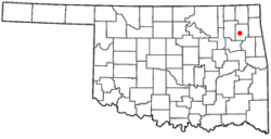 Location of Pryor Creek within Oklahoma | |
| Coordinates: 36°18′30″N 95°19′1″W / 36.30833°N 95.31694°WCoordinates: 36°18′30″N 95°19′1″W / 36.30833°N 95.31694°W[1] | |
| Country | United States |
| State | Oklahoma |
| County | Mayes |
| Government | |
| • Mayor | Jimmy Tramel [2] |
| Area | |
| • Total | 6.5 sq mi (16.9 km2) |
| • Land | 6.5 sq mi (16.8 km2) |
| • Water | 0.04 sq mi (0.1 km2) 0.31% |
| Elevation[1] | 630 ft (192 m) |
| Population (2010) | |
| • Total | 9,539 |
| • Density | 1,500/sq mi (560/km2) |
| Time zone | CST (UTC-6) |
| • Summer (DST) | CDT (UTC-5) |
| Area code | 918/539 |
| FIPS code | 40-60950 [1] |
| GNIS feature ID | 1102850 [1] |
| Website | pryorok.org |
Pryor Creek, more commonly known as Pryor, is a city in and county seat of Mayes County, Oklahoma, United States.[1] The population was 8,659 at the 2000 census, compared to 9,539 in the 2010 census.[3]
Originally named Coo-Y-Yah, Cherokee for Huckleberry, it was renamed Pryor Creek in 1887, the name of the local railroad station (named for the creek). Due to confusion in distinguishing handwritten mailing addresses to Pryor Creek and Pond Creek, the U.S. Postal Service name for the city was shortened to Pryor, though the official name of the city remains Pryor Creek.[4]
History
In the early 1800s, treaties with the Cherokee, Osage, and Choctaw gave the tribes allotments in Indian Territory in the region that would become Oklahoma.[5] Captain Nathaniel Hale Pryor, who was married to an Osage woman and served as an agent to the Osage people, was among those settling northeastern Oklahoma.[6] He established a trading post on Grand River, shortly before the Union Mission was established 5 miles southeast of present-day Chouteau in 1820.[7]
In 1870, the Missouri-Kansas-Texas Railroad started construction in the Cherokee Nation along the Kansas border, laying tracks to Texas. By June 1871, the railroad reached present-day Pryor Creek.[8]
A post office was eventually established naming the town Coo-y-yah, Indian Territory. Coo-y-yah is the Cherokee name for "huckleberry". On April 23, 1887, Coo-y-yah was changed to Pryor Creek, but the "Creek" was dropped by the post office on January 26, 1909.[4][The official name of the city government is still Pryor Creek despite a proposition put before voters in 1963 to change the name.[8]
In 1951, voters approved the present city charter of a mayor-council government system, which provided for the election of a mayor, clerk, treasurer, police chief and eight councilors. The charter also established a cemetery, park, library board, and a municipal utility board, which oversees operations of the city-owned gas, water, electric and sewer systems.[8]
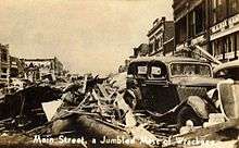
On April 27, 1942, a tornado swept along Pryor Creek's main street from the western edge of the business district to the eastern edge of the city, destroying nearly every building and causing extensive damage to the residential section. The storm killed 52 people, according to the U.S. Weather Bureau, but The Associated Press set the total at 60 two days after the storm. More than 400 were injured in the storm that caused damage estimated at US$3 million.[8]
The F4 tornado struck about 5 p.m. (17:00) local time, an hour and a half after one hit near Talala, Oklahoma, and mowed a path about 5 miles (8 km) long, killing three and injuring 12. Talala, which was not hit, is about 30 miles (48 km) northwest of Pryor Creek. Governor Leon C. Phillips put the area under martial law, but because the Oklahoma National Guard had been activated for service during World War II, he sent state troopers to rescue victims, maintain order and prevent looting.[9]
The Pryor tornado ranks as the fifth deadliest in Oklahoma history behind tornadoes at Woodward in 1947, Snyder in 1905, Peggs in 1920, and Antlers in 1945. The May 3, 1999, tornado at Midwest City caused more damage but fewer deaths.[10]
Geography
Pryor Creek is located at 36°18′30″N 95°19′1″W / 36.30833°N 95.31694°W ( 36.3084275, -95.3169136 ).[1] According to the United States Census Bureau, the city has a total area of 6.5 square miles (16.9 km²), of which, 6.5 square miles (16.8 km²) of it is land and 0.04 square miles (0.1 km²) of it (0.31%) is water.
Demographics
| Historical population | |||
|---|---|---|---|
| Census | Pop. | %± | |
| 1900 | 495 | — | |
| 1910 | 1,798 | 263.2% | |
| 1920 | 1,767 | −1.7% | |
| 1930 | 1,828 | 3.5% | |
| 1940 | 2,501 | 36.8% | |
| 1950 | 4,486 | 79.4% | |
| 1960 | 6,476 | 44.4% | |
| 1970 | 7,057 | 9.0% | |
| 1980 | 8,483 | 20.2% | |
| 1990 | 8,327 | −1.8% | |
| 2000 | 8,659 | 4.0% | |
| 2010 | 9,539 | 10.2% | |
| Est. 2015 | 9,469 | [11] | −0.7% |
As of the 2010 census Pryor Creek had a population of 9,539. The racial and ethnic composition of the population was 72.3% white, 0.7% African American, 16.9% Native American, 0.6% Asian, 1.9% reporting some other race and 7.7% reporting two or more races. Hispanic or Latino Americans were 4.9% of the population.[13]
As of the census[14] of 2000, there were 8,659 people, 3,567 households, and 2,343 families residing in the city. The population density was 1,332.5 people per square mile (514.3/km²). There were 3,887 housing units at an average density of 598.2 per square mile (230.9/km²). The racial makeup of the city was 77.91% White, 0.29% African American, 14.12% Native American, 0.62% Asian, 0.02% Pacific Islander, 0.97% from other races, and 6.06% from two or more races. Hispanic or Latino were 2.78% of the population.
There were 3,567 households out of which 30.2% had children under the age of 18 living with them, 52.1% were married couples living together, 10.6% had a female householder with no husband present, and 34.3% were non-families. 30.9% of households were made up of individuals and 16.3% had someone living alone who was 65 years of age or older. The average household size was 2.35 and the average family size was 2.95.
In the city the population was spread out with 26.1% under the age of 18, 9.5% from 18 to 24, 25.7% from 25 to 44, 19.9% from 45 to 64, and 18.8% who were 65 years of age or older. The median age was 36 years. For every 100 females there were 91.4 males. For every 100 females age 18 and over, there were 84.6 males.
The median income for a household in the city was $29,424, and the median income for a family was $37,115. Males had a median income of $33,547 versus $20,737 for females. The per capita income for the city was $16,887. About 10.8% of families and 13.6% of the population were below the poverty line, including 19.9% of those under age 18 and 6.4% of those age 65 or over.
Government
The mayor is elected city-wide for a two-year term. The city is divided into four wards which each elect two councilmen to two-year terms.[4]
Education
Pryor Public Schools includes four primary, one junior high school, one senior high school, a performing arts auditorium and a basketball arena.[8]
Pryor Creek is also home to Northeast Technology Center-Pryor and Pryor Beauty College.[15] Rogers State University has a branch campus in Pryor.[8]
The Thunderbird Youth Academy, funded by the Federal Government and operated by the Oklahoma National Guard, is a twenty two-week program to help high school dropouts restructure their lives. It is open to men and women who are Oklahoma residents, 16 to 18 years old, and is free to the participants. It is held at the site of the former Whitaker State Orphans Home.[4]
Economy


MidAmerica Industrial Park is located about 4 miles (6.4 km) south of Pryor.[16]
In May 2007 Google announced its plans to build a large Internet data center at the Mid-America Industrial Park. The $600 million facility is now open and employs around 100 people. Google shut the worksite down in 2008 because of the status of the United States economy and work on its overseas projects and affairs,[17] then restarted the project in October 2010 and opened at the end of September 2011.[18][19]
According to the Encyclopedia of Oklahoma History and Culture, manufacturing employs about 40 percent of the city's workforce. It is the seventh largest manufacturing center in the state. The main industries that it serves are: machinery, metals, electronics and transportation equipment.[4]
Annual festivals
Pryor Creek is home of Catch the Fever Music Festivals, which is host to Rocklahoma, just 4 miles (6.4 km) north of Pryor Creek.
Parks and recreation
Area recreational facilities include a brand new state of the art municipal recreation center that includes an indoor swimming pool, fitness center, meeting rooms and a chapter of the Boys and Girls Club. Pryor also has five city parks, Whitaker, Centennial, Roosevelt, Bobby Buck, Earl Ward, as well as a softball & baseball complex. Earl Ward Park is home of the city-owned 18-hole golf course and is located just east of the industrial park on Highway 69A. Pryor is also just a few miles away from Lake Hudson, Grand Lake and Ft. Gibson Lake
Notable people
- Joseph "Jocko" Clark - US Navy admiral
- "Indian" Bob Johnson - professional baseball player
- Cliff Mapes - professional baseball player
- Gene R. Redden - Founder and Administrator, Mid-America Industrial Park - Appointed for life by Governor of Oklahoma
- Clyde Van Sickle - professional football player
- Hank Wyse - professional baseball player
References
- 1 2 3 4 5 6 Geographic Names Information System (GNIS) details for Pryor, Oklahoma; United States Geological Survey (USGS); October 13, 1978.
- ↑ Mayor's Office; Pryor Creek government.
- ↑ Pryor Daily Times, "Mayes County Grows by 3,000." April 11, 2011. Retrieved July 16, 2011.
- 1 2 3 4 5 George W. Tilly, "Pryor Creek," Encyclopedia of Oklahoma History and Culture. Accessed August 5, 2013)
- ↑ "Dianna Everett, "Indian Territory." Encyclopedia of Oklahoma History and Culture. Accessed August 5, 2013
- ↑ May, Jon D. "Pryor, Nathaniel," Encyclopedia of Oklahoma History and Culture. Accessed August 5, 2013)
- ↑ Amanda Carney, "Mayes County, Encyclopedia of Oklahoma History and Culture. Accessed August 5, 2013
- 1 2 3 4 5 6 Pryor, Oklahoma. "History of Pryor." Retrieved October 15, 2013.
- ↑ "Pryor Creek tornado disaster," New York Times, April 28, 1942. (accessed August 5, 2013)
- ↑ "Oklahoma’s 10 deadliest tornadoes." NewsOK. March 7, 2009. (accessed August 5, 2013)
- ↑ "Annual Estimates of the Resident Population for Incorporated Places: April 1, 2010 to July 1, 2015". Retrieved July 2, 2016.
- ↑ "Census of Population and Housing". Census.gov. Retrieved June 4, 2015.
- ↑ 2010 general profile of population and housing characteristics of Pryor Creek at [factfinder2.census.gov/ American FactFinder] (accessed August 5, 2013)
- ↑ "American FactFinder". United States Census Bureau. Retrieved 2008-01-31.
- ↑ AreaVibes.com - Pryor Creek - Education (accessed August 5, 2013)
- ↑ "Small-town Pryor getting some big hits". Tulsa World: tulsaworld.com. Retrieved 2011-09-14.
- ↑ Google Confirms $600 mil Project
- ↑ Kyle Arnold, Google reboots data site in Pryor, Tulsa World, October 22, 2010.
- ↑ Robert Evatt, Google plugs in data center in Pryor, Tulsa World, September 30, 2011
External links
| Wikivoyage has a travel guide for Pryor. |
Municipalities and communities of Mayes County, Oklahoma, United States | ||
|---|---|---|
| City | 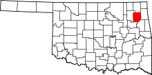 | |
| Towns | ||
| CDPs | ||
| Unincorporated communities |
| |
| Footnotes | ‡This populated place also has portions in an adjacent county or counties | |