Putana Volcano
| Putana | |
|---|---|
 The Putana volcano seen from the west. | |
| Highest point | |
| Elevation | 5,890 m (19,320 ft) |
| Coordinates | 22°33′S 67°51′W / 22.550°S 67.850°WCoordinates: 22°33′S 67°51′W / 22.550°S 67.850°W |
| Geography | |
| Location | Bolivia-Chile |
| Parent range | Andes |
| Geology | |
| Mountain type | Stratovolcano |
| Last eruption | 1810 ± 10 years |
Putana (also known as Jorqencal or Machuca) is a stratovolcano on the border between Bolivia and Chile. It lies immediately NNE of Cerro Colorado, about 6 km (4 mi) north of Volcán Escalante, the northernmost member of the Sairecabur complex and 14 km (9 mi) south of the Cerros de Tocorpuri complex. Intense fumarolic activity occurs at its summit, and a solfatara (see fumarole) can be observed in the main crater.
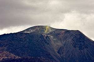
Solfatara (yellow) and fumaroles on the summit of Putana
See also
References
- "Putana". Global Volcanism Program. Smithsonian Institution.
- González-Ferrán, Oscar (1995). Volcanes de Chile. Santiago, Chile: Instituto Geográfico Militar. p. 640 pp. ISBN 956-202-054-1.(Spanish)
External links
- SI Google Earth Placemarks - Smithsonian Institution Global Volcanism Program: Download placemarks with SI Holocene volcano-data.
This article is issued from Wikipedia - version of the 6/14/2015. The text is available under the Creative Commons Attribution/Share Alike but additional terms may apply for the media files.