Qila Rai Pithora
Qila Rai Pithora, also known as Rai Pithora's Fort, was a fortified city built in the 12th century by Chauhan king, Prithviraj Chauhan. Chauhan Rajputs had taken over the city of Delhi, from Tomar Rajputs. It also incorporated, much older Lal Kot built earlier by 8th-century Tomar Rajput ruler, Anang Pal I. Qila is a Persian word meaning a fort or castle.[1] At that time it was either called Durg or Garh Rai Pithora. Durg and Garh are a Sanskrit words meaning Fort and/or citadel. It was from the fort that the Tomar, Chauhan and the Slave Dynasty ruled over Delhi from 12th to 13th century.
Remains of the fort walls are scattered across South Delhi, visible in present Saket, Mehrauli around Qutb complex, Kishangarh and Vasant Kunj areas.[2]
History
In 1160 AD, the Chauhan rulers took over Delhi from Tomars, along with it the fort city of Lal Kot, the first extant city of Delhi. Thereafter Prithviraj Chauhan whose capital was Ajmer in Rajasthan, enlarged the Lal Kot, which had large rubble walls and ramparts, and renamed it Qila (Fort) of Rai Pithora or Qila Rai Pithora. The combined fort extended to six and a half km, and city existed with the fort, while older Lal Kot served as the citadel.[3] However, the Chauhan's didn't rule long over the city, in 1190s the Afghans started attacking. Though Chauhans defeated Muhammad Ghori in the First Battle of Tarain in 1191, a year later in 1192, his general Qutubuddin Aibak defeated Prithviraj Chauhan in the Second Battle of Tarain, ending their dynasty. This in turn established Muslim rule in India, with his Mamluk dynasty also known as Slave dynasty, the first Sultanate of Delhi. However, Aibak didn't extend or change the fort structure, it remained same through his early successors as well.[4]
Important sections
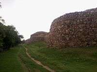
 Gateway of Rai Pithora Fort
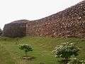 Round bastions of Rai Pithora.
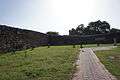 Bastion of Jahanpanah meets the wall of Qila Rai Pithora fort.
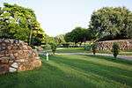
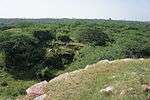 Walls of Lal Kot and Rai Pithora's fort at the point where they meet together
 Entrance signage for Qila Rai Pithora complex.
See also
References
- ↑ "Seven Cities Of Delhi: Qila Rai Pithora". Government of Delhi. Retrieved July 25, 2013.
- ↑ "Lal Kot or Quila Rai Pithora". Delhi Tourism. Retrieved July 25, 2013.
- ↑ Tracy, p. 252
- ↑ Tracy, p. 253
Bibliography
| Wikimedia Commons has media related to Qila Rai Pithora. |
- James D. Tracy (25 September 2000). City Walls: The Urban Enceinte in Global Perspective. Cambridge University Press. ISBN 978-0-521-65221-6. Retrieved 7 August 2013.
Coordinates: 28°31′09″N 77°11′27″E / 28.5192°N 77.1909°E