Lohagad
| Lohagad | |
|---|---|
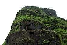
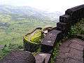
 Main entrance to Lohagad fort. | |
| Highest point | |
| Elevation | 3,390 ft (1,030 m) |
| Coordinates | 18°42′32″N 73°28′36″E / 18.70889°N 73.47667°ECoordinates: 18°42′32″N 73°28′36″E / 18.70889°N 73.47667°E |
| Naming | |
| Translation | लोहगड |
| Geography | |
 Lohagad Location of Lohagad in Maharashtra | |
| Location |
|
| Parent range | Western Ghats |
Lohagad (Marathi: लोहगड, iron fort) is one of the many hill forts of Maharashtra state in India. Situated close to the hill station Lonavala and 52 km (32 mi) northwest of Pune, Lohagad rises to an elevation of 1,033 m (3,389 ft) above sea level. The fort is connected to the neighboring Visapur fort by a small range. The fort was under the Maratha empire for the majority of time, with a short period of 5 years under the Mughal empire.
History
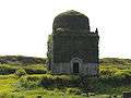
Lohagad has a long history with several dynasties occupying it at different periods of time: Satavahanas, Chalukyas, Rashtrakutas, Yadavas, Bahamanis, Nizams, Mughals and Marathas. Shivaji Maharaj captured it in 1648 CE, but he was forced to surrender it to the Mughals in 1665 CE by the Treaty of Purandar. Shivaji Maharaj recaptured the fort in 1670 CE and used it for keeping his treasury. This fort was used to keep the loot from Surat. Later in Peshwa time Nana Phadnavis used this fort for living for sometime and built several structures in the fort such as a big tank and a step-well.
The fort has been declared as a protected monument by the government.[1]
Geography and Climate

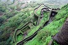
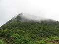
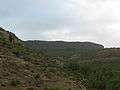
Lohagad is part of the Western Ghats. It rises to an elevation of 1,033 m (3,389 ft) above sea level, and is located to the southwest of the larger Visapur fort. The range divides the basins of the Indrayani and Pavana rivers. Lohagad overlooks the Pavana reservoir, located to the south of the mountain. The hill extends to the northwest to a fortified spur, called Vinchukata (Scorpion's tail) because of its resembling shape. The four large gates of Lohagad are still in good condition and reasonably intact.

During the monsoon, the top of the fort is covered with mist and clouds and becomes particularly wet with growing moss. The roads and trails leading to the hill are quite slippery at this time of the year and precautions are necessary to be taken while venturing the routes.
Accessibility
Lohagad fort can be accessed by various modes of travel. The nearest airport is the Pune International Airport. The proposed Navi Mumbai International Airport will serve as the nearest airport in the coming future.
The nearest train station is Malavli, which can be accessed by suburban trains between Lonavala and Pune. The nearest major train station is Lonavala, on the Mumbai-Pune railway line. Lohagad is connected by the Mumbai-Pune Highway and can also be accessed from Paud via Kolvan and Dudhiware Khind for all vehicles.
People can also hike all the way to the fort. Bhaja Caves is on the way to Lohagad if a small diversion is taken. This walk is a particular favorite of trekkers, especially in the monsoon season. It is a simple, very scenic and pleasant trek and the distance from Malavli and Lohagad can be covered in around two hours. The trekking route becomes slippery during the rainy season and is dangerous to hike to the fort during this time. A variety of birds and insects can also be spotted in these hills.
Nearby attractions
- Bhaja Caves - 2 km (1.2 mi) from Malavli, once home to Buddhist monks.
- Karla Caves
- Lonavala - 20 km (12 mi), a famous and scenic hill station.
- Aamby Valley City - 22 km (14 mi) from Lonavala.
Gallery
See also
External links
| Wikimedia Commons has media related to Lohagad. |
- Lohagad at MTDC site
- Lohagad Fort - How to go, places to visit, things to do
- Lohagad Fort Trek Review Blog - All you wanted to know.
- Visapur Fort Trek Review Blog - All you wanted to know.