R118 road (Ireland)
| |
|---|---|
| Road network | |

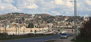
The R118 at Cherrywood looking east towards Killiney hill
The R118 road is a regional road in south Dublin and Dún Laoghaire–Rathdown, Ireland. It links Kildare Street to Cherrywood.
The official description of the R118 from the Roads Act 1993 (Classification of Regional Roads) Order 2006 [1] reads:
- R118: Dublin - Blackrock, County Dublin and Dún Laoghaire - Lahaunstown, County Dublin
- Between its junction with N11 at Kildare Street in the city of Dublin and its junction with N31 at Mount Merrion Avenue in the county of DunLaoghaire - Rathdown via Leinster Street South (and via Lincoln Place, Westland Row, and Pearse Street), Clare Street, Merrion Square North, Mount Street Lower, Northumberland Road, Pembroke Road, Ballsbridge and Merrion Road in the city of Dublin: and Rock Road in the county of Dún Laoghaire–Rathdown
- and
- between its junction with N31 at Crofton Road and its junction with M50 at Lahaunstown via Marine Road, George's Street Upper (and via Park Road and Queen's Road), Glenageary Road Lower, Sallyglen Road, Church Road, Ballybrack dual carriageway, Wyattville Road and Wyattville Link Road all in the county of Dún Laoghaire–Rathdown.
See also
References
- ↑ Statutory Instrument 188 of 2006 — Roads Act 1993 (Classification of Regional Roads) Order 2006, Irish Statute Book (irishstatutebook.ie). Retrieved 2010-08-02.
This article is issued from Wikipedia - version of the 7/7/2013. The text is available under the Creative Commons Attribution/Share Alike but additional terms may apply for the media files.