R574 road (Ireland)
| |
|---|---|
| Road network | |
Coordinates: 51°43′20″N 9°45′26″W / 51.722192°N 9.757088°W
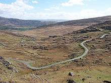

The R574 is an Irish regional road in the Beara peninsula which crosses the Caha Mountains via the (Tim) Healy Pass.[1] It runs from the R572 at Adrigole in County Cork to the R571 near Lauragh in County Kerry.[1] It is a popular tourist route with the pass at an altitude of 300m giving panoramas towards Bantry Bay to the south-east and the Kenmare River to the north-west.
The original track, called the Kerry Pass, was cut during the Great Famine as a poor relief public works project. It was renamed for Timothy Michael Healy, former Governor-General of the Irish Free State, who died in 1931 shortly after the road was improved.[2] The name "Healy Pass" is now also applied to the pass itself, previously called Ballaghscart or Ballyscarta, anglicisations of Irish: Bealach Scairte, which remains its Irish name.[3]
References
- 1 2 "S.I. No. 54/2012 — Roads Act 1993 (Classification of Regional Roads) Order 2012.". Irish Statute Book. Retrieved 26 March 2012.
- ↑ Callanan, Frank (1996). T.M. Healy. Cork University Press. p. 627. ISBN 9781859181720. Retrieved 26 March 2012.
- ↑ "Healy Pass". Placenames Database of Ireland. Retrieved 26 March 2012.