Rajendra Setu
| Rajendra Setu | |
|---|---|
| Coordinates | 25°22′32″N 85°59′54″E / 25.3756°N 85.9983°E |
| Carries | Mokama-Barauni rail track, NH 31 |
| Crosses | Ganges |
| Locale | near Hathidah |
| Characteristics | |
| Design | Girder bridge |
| Total length | 2,000 metres (6,600 ft) |
| Number of spans |
14 x 400 ft 4 x 100 ft |
| History | |
| Engineering design by | Braithwaite, Burn & Jessop Construction Company |
| Opened | 1959 |
| Statistics | |
| Daily traffic | Double road track & Single line rail track |
| Toll | no |
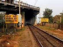
Rajendra Setu (also known as Rajendra Pul and Mokama Bridge) is a bridge across the River Ganges that was the first bridge to link the northern and southern portions of the state of Bihar.[1][2] The location of the bridge was based on the work of M. Visvesvaraya, who was more than 90 years old at the time.[3][4] The road-cum-rail bridge near Hathidah in Patna district was inaugurated in 1959 by Dr. Rajendra Prasad, President of India. Construction of the bridge was by Braithwaite, Burn & Jessop Construction Company. It is about 2 kilometres (1.2 mi) long and carries a two lane road and a single line railway track.[5][6][7] A double-track railway bridge 25 metres upstream from the bridge is under costruction.[8][9]
A four-lane road bridge, carrying NH 31, parallel to the existing rail and road bridge, has also been planned.[10]
See also
- List of longest bridges in the world
- List of longest bridges above water in India
- Digha–Sonpur bridge
References
- ↑ "Rajendra bridge falls off radar".
- ↑ "Ganga bridge bonanza New projects to ease travel hassle".
- ↑ "Sir's inimitable vision".
- ↑ "THE JEWEL OF KARNATAKA".
- ↑ "Rlys begins bridge renovation work". Times of India, Patna, 12 July 2010. 12 July 2010. Retrieved 2011-07-03.
- ↑ "Million dreams".
- ↑ "Indian railways history (after independence)". Indian Railways. Retrieved 2011-07-03.
- ↑ http://www.dnaindia.com/money/report-pm-modi-inaugurates-three-major-railway-projects-worth-rs-7000-crore-in-bihar-2188606
- ↑ http://timesofindia.indiatimes.com/city/patna/New-Mokama-rail-bridge-likely-to-be-completed-in-4-yrs/articleshow/51385623.cms
- ↑ "Four-lane connector over Sone, Ganga". The Telegraph, 8 April 2011. Retrieved 25 June 2011.
| Wikimedia Commons has media related to Rajendra Setu. |
Railways in Bihar | |||||||||||||||||||
|---|---|---|---|---|---|---|---|---|---|---|---|---|---|---|---|---|---|---|---|
| Network Lines Sections |
| ||||||||||||||||||
| Rail Bridges |
| ||||||||||||||||||
| |||||||||||||||||||