Redland, Alabama
| Redland, Alabama | |
|---|---|
| Census-designated place | |
 Redland | |
| Coordinates: 32°28′53″N 86°08′38″W / 32.48139°N 86.14389°WCoordinates: 32°28′53″N 86°08′38″W / 32.48139°N 86.14389°W | |
| Country | United States |
| State | Alabama |
| County | Elmore |
| Area[1] | |
| • Total | 24.290 sq mi (62.91 km2) |
| • Land | 24.142 sq mi (62.53 km2) |
| • Water | 0.148 sq mi (0.38 km2) |
| Elevation | 433 ft (132 m) |
| Population (2010)[2] | |
| • Total | 3,736 |
| • Density | 150/sq mi (59/km2) |
| Time zone | Central (CST) (UTC-6) |
| • Summer (DST) | CDT (UTC-5) |
| Area code(s) | 334 |
| GNIS feature ID | 2582696[3] |
Redland is a census-designated place in Elmore County, Alabama, United States. Its population was 3,736 as of the 2010 census.[2]
References
- ↑ "US Gazetteer files: 2010, 2000, and 1990". United States Census Bureau. 2011-02-12. Retrieved 2011-04-23.
- 1 2 "American FactFinder". United States Census Bureau. Retrieved 2011-05-14.
- ↑ "Redland Census Designated Place". Geographic Names Information System. United States Geological Survey.
Municipalities and communities of Elmore County, Alabama, United States | ||
|---|---|---|
| Cities | 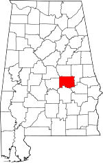 | |
| Towns | ||
| CDPs | ||
| Unincorporated communities | ||
| Footnotes | ‡This populated place also has portions in an adjacent county or counties | |
This article is issued from Wikipedia - version of the 1/20/2016. The text is available under the Creative Commons Attribution/Share Alike but additional terms may apply for the media files.