Relief, Kentucky
| Relief | |
|---|---|
| Unincorporated community | |
 Relief  Relief Location within the state of Kentucky | |
| Coordinates: 37°56′41″N 82°59′43″W / 37.94472°N 82.99528°WCoordinates: 37°56′41″N 82°59′43″W / 37.94472°N 82.99528°W | |
| Country | United States |
| State | Kentucky |
| County | Morgan |
| Elevation | 732 ft (223 m) |
| Time zone | Eastern (EST) (UTC-5) |
| • Summer (DST) | EDT (UTC-4) |
| GNIS feature ID | 508918 |
Relief is an unincorporated community in Morgan County, Kentucky, United States. It lies along Route 172 east of the city of West Liberty, the county seat of Morgan County.[1] Its elevation is 732 feet (223 m).[2]
References
- ↑ Rand McNally. The Road Atlas '06. Chicago: Rand McNally, 2006, p. 43.
- ↑ U.S. Geological Survey Geographic Names Information System: Relief, Kentucky, Geographic Names Information System, 1979-09-20. Accessed 2008-01-03.
Municipalities and communities of Morgan County, Kentucky, United States | ||
|---|---|---|
| City | 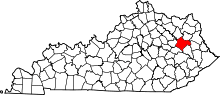 | |
| CDP | ||
| Other unincorporated communities | ||
This article is issued from Wikipedia - version of the 7/27/2016. The text is available under the Creative Commons Attribution/Share Alike but additional terms may apply for the media files.