Wrigley, Kentucky
| Wrigley | |
|---|---|
| unincorporated community | |
|
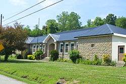
The former elementary school | |
 Wrigley  Wrigley Location within the state of Kentucky | |
| Coordinates: 38°1′6″N 83°16′17″W / 38.01833°N 83.27139°WCoordinates: 38°1′6″N 83°16′17″W / 38.01833°N 83.27139°W | |
| Country | United States |
| State | Kentucky |
| County | Morgan |
| Elevation | 817 ft (249 m) |
| Time zone | Eastern (EST) (UTC-5) |
| • Summer (DST) | EDT (UTC-4) |
| GNIS feature ID | 516490 |
Wrigley is an unincorporated community in Morgan County, Kentucky, United States. It lies along Route 7, north of the city of West Liberty, the county seat of Morgan County.[1] Its elevation is 817 feet (249 m), and it is located at 38°1′6″N 83°16′17″W / 38.01833°N 83.27139°W (38.0184184, -83.2712887).[2] Although it is unincorporated, it has a post office, with the ZIP code of 41477.[3]
Landmarks
- Wrigley Falls - natural waterfall
- Wrigley Natural Bridge
- Wrigley Elementary School - constructed by WPA in 1936, now closed.
Climate
The climate in this area is characterized by relatively high temperatures and evenly distributed precipitation throughout the year. The Köppen Climate System describes the weather as humid subtropical, and uses the abbreviation Cfa.[4]
| Climate data for Wrigley, Kentucky | |||||||||||||
|---|---|---|---|---|---|---|---|---|---|---|---|---|---|
| Month | Jan | Feb | Mar | Apr | May | Jun | Jul | Aug | Sep | Oct | Nov | Dec | Year |
| Average high °C (°F) | 6 (43) |
8 (47) |
14 (57) |
20 (68) |
25 (77) |
29 (84) |
31 (87) |
30 (86) |
27 (80) |
21 (70) |
14 (57) |
8 (46) |
19 (67) |
| Average low °C (°F) | −7 (20) |
−6 (21) |
−1 (30) |
3 (38) |
9 (48) |
14 (57) |
17 (62) |
16 (60) |
11 (52) |
4 (39) |
−1 (30) |
−5 (23) |
4 (40) |
| Average precipitation mm (inches) | 86 (3.4) |
81 (3.2) |
107 (4.2) |
89 (3.5) |
107 (4.2) |
100 (4) |
135 (5.3) |
97 (3.8) |
81 (3.2) |
66 (2.6) |
81 (3.2) |
91 (3.6) |
1,123 (44.2) |
| Source: Weatherbase [5] | |||||||||||||
References
- ↑ Rand McNally. The Road Atlas '06. Chicago: Rand McNally, 2006, p. 43.
- ↑ Geographic Names Information System Feature Detail Report, Geographic Names Information System, 1979-09-20. Accessed 2008-01-03.
- ↑ Zip Code Lookup
- ↑ Climate Summary for Wrigley, Kentucky
- ↑ "Weatherbase.com". Weatherbase. 2013. Retrieved on September 6, 2013.
Municipalities and communities of Morgan County, Kentucky, United States | ||
|---|---|---|
| City | 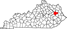 | |
| CDP | ||
| Other unincorporated communities | ||
This article is issued from Wikipedia - version of the 9/19/2016. The text is available under the Creative Commons Attribution/Share Alike but additional terms may apply for the media files.