Ringgold, Louisiana
| Ringgold, Louisiana | |
| Town | |
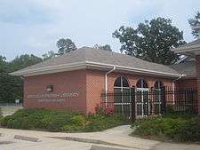 Ringgold branch of the Bienville Parish Library | |
| Country | United States |
|---|---|
| State | Louisiana |
| Parish | Bienville |
| Elevation | 279 ft (85.0 m) |
| Coordinates | 32°19′35″N 93°17′01″W / 32.32639°N 93.28361°WCoordinates: 32°19′35″N 93°17′01″W / 32.32639°N 93.28361°W |
| Area | 2.3 sq mi (6.0 km2) |
| - land | 2.3 sq mi (6 km2) |
| - water | 0.0 sq mi (0 km2) |
| Population | 1,495 (2010) |
| Density | 249.3/km2 (645.7/sq mi) |
| Mayor | Donna Short Wiggins (D) (elected 2013) |
| Timezone | CST (UTC-6) |
| - summer (DST) | CDT (UTC-5) |
| Area code | 318 |
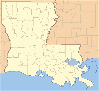 Location of Ringgold in Louisiana
| |
 Location of Louisiana in the United States
| |
Ringgold is a town in Bienville Parish, Louisiana, United States. The population was 1,495 at the 2010 census.[1] Ringgold is named for United States Army Major Samuel Ringgold, the hero of the Battle of Palo Alto near Brownsville, Texas, in the Mexican–American War. Ringgold, the son of a congressman from Maryland, was known for his particularly effective use of artillery. He was also the first American casualty of the Mexican War.
In November 1933, C. E. Tomme (1882-1948),[2] a telephone executive who was previously a county commissioner of Newton County in East Texas, was appointed mayor of Ringgold by Governor Oscar K. Allen. Tomme, who relocated to Ringgold in 1920, filled the position vacated by his fellow Democrat, Walter McDowell. Tomme previously served on the Bienville Parish School Board and the parish Democratic Executive Committee.[3] In the spring of 1934, Tomme won election to the post, 86-66, over Dave Thomas.[4]
On May 2, 1984, a tornado devastated part of Ringgold. Nine were injured, though there were no deaths. The storm reached as far as nearby Jamestown.[5]
Loggy Bayou, which links Lake Bistineau with the Red River, flows through Bienville Parish west of Ringgold.
Geography
Ringgold is located in western Bienville Parish at 32°19′35″N 93°17′1″W / 32.32639°N 93.28361°W (32.326475, -93.283588).[6]
According to the United States Census Bureau, the town has a total area of 2.3 square miles (6.0 km2), all land.
Demographics
| Historical population | |||
|---|---|---|---|
| Census | Pop. | %± | |
| 1880 | 133 | — | |
| 1920 | 335 | — | |
| 1930 | 618 | 84.5% | |
| 1940 | 1,006 | 62.8% | |
| 1950 | 1,007 | 0.1% | |
| 1960 | 953 | −5.4% | |
| 1970 | 1,731 | 81.6% | |
| 1980 | 1,655 | −4.4% | |
| 1990 | 1,856 | 12.1% | |
| 2000 | 1,660 | −10.6% | |
| 2010 | 1,495 | −9.9% | |
| Est. 2015 | 1,432 | [7] | −4.2% |
As of the census[9] of 2000, there were 1,660 people, 636 households, and 410 families residing in the town. The population density was 715.3 people per square mile (276.3/km²). There were 749 housing units at an average density of 322.8 per square mile (124.7/km²). The racial makeup of the town was 43.92% White, 55.30% African American, 0.30% Native American, 0.06% Asian, and 0.42% from two or more races. Hispanic or Latino of any race were 0.54% of the population.
There were 636 households out of which 32.4% had children under the age of 18 living with them, 34.4% were married couples living together, 26.3% had a female householder with no husband present, and 35.4% were non-families. 32.1% of all households were made up of individuals and 17.0% had someone living alone who was 65 years of age or older. The average household size was 2.49 and the average family size was 3.13.
In the town the population was spread out with 28.9% under the age of 18, 8.9% from 18 to 24, 21.1% from 25 to 44, 21.6% from 45 to 64, and 19.6% who were 65 years of age or older. The median age was 37 years. For every 100 females there were 77.7 males. For every 100 females age 18 and over, there were 68.0 males.
The median income for a household in the town was $15,326, and the median income for a family was $21,563. Males had a median income of $25,000 versus $15,625 for females. The per capita income for the town was $9,817. About 36.5% of families and 38.4% of the population were below the poverty line, including 48.9% of those under age 18 and 33.3% of those age 65 or over.
Notable people
- Stephen A. Caldwell, educator, principal at Ringgold High School, 1911-1914
- Barbara Colley, romance and mystery novelist from New Orleans
- Billy McCormack, Baptist pastor from Shreveport, director and vice president of the Christian Coalition of America; born in Bienville Parish and interred at Providence Cemetery in Ringgold
- Garnie W. McGinty, Louisiana historian
- Duvall Cortez Wimberly, born in Ringgold, president of American Ex–Prisoners of War
- Bill Conly, Regional folk and Celtic musician and a forester, reared near Ringgold [10]
Gallery
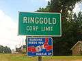 Ringgold corporate limits sign
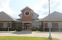
 Ringgold Town Hall
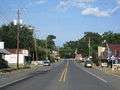 A glimpse of downtown Ringgold
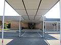 Ringgold School Complex
 Defunct Ringgold Clinic, begun by Dr. V. W. Fletcher (1893-1960) and later operated by physicians Eichelberger and Bell, is still located across from the site of the former Conger Funeral Home in Ringgold.
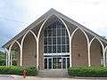 The First Baptist Church of Ringgold at the entrance to Mill Street downtown
 First United Methodist Church in Ringgold
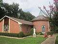 Blessed Sacrament Catholic Church in Ringgold
References
- ↑ "Geographic Identifiers: 2010 Demographic Profile Data (G001): Ringgold town, Louisiana". U.S. Census Bureau, American Factfinder. Retrieved December 2, 2013.
- ↑ "C. E. Tomme". Findagrave.com. Retrieved June 27, 2016.
- ↑ " C. E. Tomme Named Mayor of Ringgold by Governor Allen", Minden Herald, November 10, 1933, p. 1
- ↑ "C. E. Tomme Re-Elected Ringgold Mayor", Minden Herald, April 13, 1934, p. 1
- ↑ Marilyn Miller, "Tornado devastates town of Ringgold", Minden Press-Herald, May 3, 1984, p. 1
- ↑ "US Gazetteer files: 2010, 2000, and 1990". United States Census Bureau. 2011-02-12. Retrieved 2011-04-23.
- ↑ "Annual Estimates of the Resident Population for Incorporated Places: April 1, 2010 to July 1, 2015". Retrieved July 2, 2016.
- ↑ "Census of Population and Housing". Census.gov. Retrieved June 4, 2015.
- ↑ "American FactFinder". United States Census Bureau. Retrieved 2008-01-31.
- ↑ http://www.louisianafolklife.org/LT/Articles_Essays/ShrCeltic.html
Municipalities and communities of Bienville Parish, Louisiana, United States | ||
|---|---|---|
| Towns |  | |
| Villages | ||
| Unincorporated communities | ||