River Beane
| Beane | |
| River | |
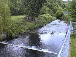 Weir on the River Beane, Hartham Common | |
| Country | United Kingdom |
|---|---|
| Source | |
| - location | Nr. Sandon, Hertfordshire |
| - elevation | 90 m (295 ft) |
| Mouth | |
| - location | Hertford, Hertfordshire into River Lea |
| Length | 17.8 km (11 mi) |
The River Beane is a short river in the county of Hertfordshire, England. A tributary of the River Lea, it rises to the south-west of Sandon in the hills northeast of Stevenage and joins the Lea at Hartham Common in Hertford.
Watermills
In medieval times there were a number of watermills along the course of the Beane. A few of the buildings and mill races survive. Perhaps the most noteworthy site is Sele Mill, upstream of Hertford. It was mentioned in the Domesday Book.[1] Its main claim to fame is that it was temporarily converted for use as a paper mill and was, as far as is known, the earliest paper mill in England. It is not clear when paper production began there, although 1488 has been suggested,[2] but it was certainly underway in the 1490s. Paper from Sele Mill was used in publications from that decade, and the mill was visited by Henry VII. Despite this sign of royal favour, paper production did not continue there for long.[3]
Abstraction
The Beane valley remains mainly rural in character. However, Hertfordshire's population increased substantially in the second half of the twentieth century, and the consequent demand for water has affected rivers such as the Beane and the Mimram. In the case of the Beane, a licence was given to abstract water near Aston for Stevenage's water supply. The river has since been adversely affected by over-exploitation of the chalk aquifer in its upper reaches.
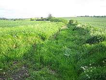
The photo shows a dry section south of Walkern where from the 1990s until about 2014 there was only seasonal flow. An indication of the scale of the decline in flow is that the section at Walkern was once big enough to power a watermill and to support watercress beds.[4]
The lower Beane is more robust and there has continued to be regular flow through Watton-at-Stone, Stapleford and Waterford until the confluence with the River Lea. However, overall the river has performed badly in assessments by the Environment Agency of flow level.
Restoration
The state of the upper Beane resulted in calls for the river´s restoration.[5] The management plan for the river includes the objective that there is adequate flow along the length of the river to support a ‘good status’ chalk stream ecology (as defined by Water Framework Directive).[6]
One possible approach to the restoration of the upper Beane was to use recycled water from sewage treatment works. Currently sewage from the Stevenage area bypasses the river, being pumped down the Beane valley to Rye Meads near Hertford for treatment.[7] Another option was chosen. Affinity Water was told to take less water from its pumping station near Aston, even though obtaining water from a less environmentally damaging source is difficult as the River Lea's catchment area as a whole is under pressure.
Access
Herts and Middlesex Wildlife Trust (HMWT) has launched a circular trail at Waterford, which includes some scenic sections of the River Beane.
References
- ↑ SELE HOUSE including front railings (1268844). Historic England
- ↑ "Sele Mill". Open Plaques. Retrieved 23 June 2015.
- ↑ Richard L. Hills, ‘Tate, John (c.1448–1507/8)’, Oxford Dictionary of National Biography, Oxford University Press, 2004; online edn, Jan 2008 accessed 24 June 2015
- ↑ Walkern Mill
- ↑ "Campaigners in walk along dry River Beane". Hertfordshire Mercury. 2012. Retrieved 10 June 2016.
- ↑ Catchment management plan
- ↑ Waste Water Report, Halcrow Group
| Wikimedia Commons has media related to River Beane. |
External links
- Press release for WWF report "Riverside Tales", 2010-04-28, WWF-UK
- Launch of the WWF report on the Rivers Beane and Mimram, Oliver Heald MP comments on WWF report.
- River Beane Catchment
Coordinates: 51°47′N 0°05′W / 51.783°N 0.083°W