Edmonton, London
| Edmonton | |
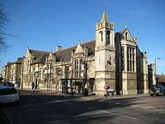 The former Charles Lamb Institute in Church Street, Edmonton. |
|
 Edmonton |
|
| Population | 96,493 (Edmonton constituency, 2001 Census) 50,473 (2011 Census.Edmonton Green Ward,Lower Edmonton Ward & Haselbury Ward only)[1] |
|---|---|
| OS grid reference | TQ335925 |
| London borough | Enfield |
| Ceremonial county | Greater London |
| Region | London |
| Country | England |
| Sovereign state | United Kingdom |
| Post town | LONDON |
| Postcode district | N9, N18 |
| Post town | ENFIELD |
| Dialling code | 020 |
| Police | Metropolitan |
| Fire | London |
| Ambulance | London |
| EU Parliament | London |
| UK Parliament | Edmonton |
| London Assembly | Enfield and Haringey |
Coordinates: 51°36′55″N 0°04′15″W / 51.6154°N 0.0708°W
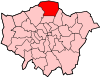
Edmonton is an area in the east of the London Borough of Enfield, England, 8.6 miles (13.8 km) north-north-east of Charing Cross. It has a long history as a settlement distinct from Enfield.
Location
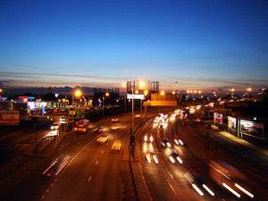
Edmonton is 8.6 miles (13.8 km) north-north-east of Charing Cross and stretches from just south of the North Circular Road where it borders Tottenham to its boundary with Ponders End to the north. Bush Hill Park, Winchmore Hill and Palmers Green adjoin the western boundary while the River Lee Diversion forms Edmonton's eastern boundary with Chingford. The northern part of Edmonton, N9 postal area is known as Lower Edmonton and the southern part as Upper Edmonton, N18 postal area.
History
The old highway Ermine Street passed through what is today Edmonton. Ermine Street was the main Roman Road from London through Lincoln and on to York. Edmonton appears in the Domesday Book of 1086, where it is recorded as Adelmetone- 'a farmstead or estate of a man called Ēadhelm' from an Old English personal name and tūn.[2]
Edmonton Hundred was a division of the historic county of Middlesex from Saxon times, an area of some 31,000 acres (125 km2) stretching up the west bank of the Lea from Tottenham to the county boundary south of Waltham Cross, and west into what is now Hertfordshire as far as South Mimms. Local government in the modern sense began in 1837 with the Edmonton Union, set up under the Poor Law Amendment Act 1834. This also covered a wide district of 47,102 acres (191 km2), including the modern boroughs of Haringey and Enfield, plus Cheshunt, Waltham Abbey and Waltham Cross. The town hall was built in 1884[3] and extended in 1903.[4]
The population of this area grew rapidly, reaching 445,875 by 1911 and would today be about 615,000. As the population mushroomed Middlesex was subdivided into many small local government areas, a much smaller Edmonton of 3894 acres (16 km2) eventually achieving the status of borough (main article Municipal Borough of Edmonton) in 1937. At the 1961 census the borough had a population of 91,956.[5] This was absorbed into the London Borough of Enfield in 1965, and the former Town Hall and civic buildings were controversially demolished by Enfield Council in 1989.[6]
Pymmes Park with its historic walled garden is Upper Edmonton's park. Pymmes Park originated as a private estate. In the late 16th century it was owned by the powerful Cecil family. In 1589 Robert Cecil, later 1st Earl of Salisbury, spent his honeymoon at Pymmes. Cecil was a protege of Francis Walsingham, Elizabeth I's chief spymaster and he succeeded him as Secretary of State in 1590. The estate was eventually acquired by Edmonton Council and opened as a public park in 1906. Pymmes House was destroyed by fire during World War II and the remains were demolished.
In the 17th century the then rural Edmonton had a reputation for supernatural activities. In approximately 1600, a play entitled The Merry Devil of Edmonton was performed in London about a wizard who lived there. In 1621 the villagers accused an old woman, Elizabeth Sawyer, of witchcraft and she was subsequently executed at Tyburn; her story was told in a pamphlet by Henry Goodcole, and in a 1621 play entitled The Witch of Edmonton.
The historic All Saints' Church is situated in Church Street as is Lamb's Cottage, which was home to writers Charles Lamb and Mary Lamb.
John Keats, the poet, was apprenticed to surgeon Dr. Hammond in Church Street between 1810-1816. The house was demolished in 1931 to be replaced by Keats Parade. An extant shop carries a blue plaque in commemoration.[7]
Edmonton was the home town of Sir James Winter Lake, director of the Hudson's Bay Company. The company's trading outpost named after Edmonton is now the capital of the Canadian province of Alberta.
The Diverting History of John Gilpin
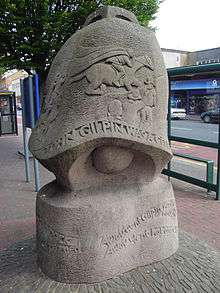
In his 1782 poem, The Diverting History of John Gilpin, William Cowper relates the comic tale of John Gilpin a linen draper of Cheapside London, who was probably based on a Mr Beyer, a linen draper of the Cheapside corner of Paternoster Row.[8]
Gilpin's spouse decides she and her husband should spend their twentieth wedding anniversary at The Bell Inn, Fore Street, Edmonton. The journey is beset with misfortune from start to finish. Gilpin loses control of his horse which carries him on to the town of Ware ten miles (16 km) distant. On the return journey, Gilpin is still unable to handle his steed, as he once again he fails to stop at The Bell. The horse gallops back to Cheapside much to the dismay of his concerned spouse.[9]
Gilpin is remembered in Edmonton by the statue at Fore Street, the Wetherspoons outlet the Gilpin's Bell public house opposite the site of the original inn and the 1950s council housing Gilpin House in Upper Fore Street.
Industry
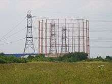
Edmonton was home to many industries which included manufacturing of gas appliances, electrical components and furniture. Most of this was lost in the latter part of the 20th century. Other household names that produced goods here included MK electric, Ever Ready batteries, British Oxygen, Glover and Main gas appliances.
Eley Industrial Estate was named after Eley Brothers the firearms cartridge manufacturer. Its shot tower was a distinctive landmark on the skyline until being demolished the late 20th century. Due to its close proximity to the River Lee Navigation, timber was transported by barge from the London Docks and stored in riverside wharves. As a result, many furniture makers including Nathans, Beautility and Homeworthy established factories. Today, Parker-Knoll products are manufactured at the former B&I Nathan factory on the Eley Industrial Estate.[10] Today (2013), the area is dominated by the 100 metre Edmonton Incinerator chimney which was built in 1971. Other major employers include Coca Cola.[11]
Railway and transport
The railway arrived in 1840 with the opening of the first section of the Lea Valley Line from Stratford to Broxbourne. A station was provided in Water Lane (Angel Road). As the station was badly sited and the trains were slow and expensive, few people used the railway in the early days, preferring the horse buses. In 1845 there were buses every 15 minutes along Fore Street, travelling alternately to Bishopsgate and Holborn.
The single-track line from a junction just north of Angel Road to Enfield Town opened on 1 March 1849, with an intermediate single-platform station at Lower Edmonton, located at the edge of the village green. The service was infrequent and often required a change of train at the junction. This, coupled with the train taking the long way round through Stratford to get to the terminus at Bishopsgate, meant that the railway offered little competition to the existing horse coaches and buses.
The direct line from London to Enfield Town was opened in four stages, from Bethnal Green to Stoke Newington on 27 May 1872; from Stoke Newington through to Lower Edmonton High Level on 22 July 1872, with stations in Edmonton at Silver Street and a new High Level station at Lower Edmonton, which was renamed Edmonton Green in 1992; the short section from Lower Edmonton High Level to Edmonton Junction (where the new line met the original Eastern Counties Railway route from Angel Road to Enfield Town via Lower Edmonton Low Level) on 1 August 1872; and the suburban platforms on the west side of Liverpool Street station on 2 February 1874.
The stations were well sited and offered exceptionally cheap workmen's fares of just 2d on trains arriving at Liverpool Street prior to 07:00, 3d on those arriving between 07:00 and 07:30, and half-price returns on those arriving between 07:30 and 08:00. A horse tramway along Fore Street opened in 1881. The tramway was re-constructed and electrified during 1905, lasting until 1938 when trolley buses took over.
Demography
2001 Census
The Edmonton constituency had a population of 96,493 in the 2001 census.[12]
The white groups made up 66.1% of the population and thirteen other ethnic groups the remainder.[12]
Constituency profile April 2004
Edmonton has a young, ethnically diverse population. Satisfaction with the area is as high as for Enfield as a whole with environmental concerns ranking highest.[12]
2011 census
- Edmonton Green ward: 20% White British, 20% Black African, 18% Other White, 10% Black Caribbean.[13]
- Upper Edmonton ward: 21% Other White, 20% White British, 15% Black African, 10% Black Caribbean.[14]
- Lower Edmonton ward: 21% White British, 18% Other White, 17% Black African, 11% Black Caribbean.[15]
Edmonton today
Since the 1960s, Edmonton has been transformed from a predominantly white, working class industrial suburb into a multicultural area by commonwealth immigration, asylum seekers [12][16] and with the expansion of the European Union in May, 2004.[17]
The Edmonton Green area is currently being redeveloped by St. Modwen Properties. The £100 million project will include new housing, bus station, clinic and refurbishment of the shopping centre.[18] In addition, a 73-room Travelodge hotel will be opened on the development.[19]
Mayor of London, Boris Johnson visited Edmonton in November 2008 to release his Time For Action plan. He claimed his proposals would help stop young people becoming repeat offenders.[20]
Edmonton currently has some of the highest levels of unemployment in Britain, with the recession of the late 2000s pushing unemployment to nearly 14% by 2009.[21]
On 18 June 2011 over 400 people marched through Edmonton to make a stand against gun and knife crime.[22]
As part of the 2012 Summer Olympics preparations, the Olympic torch relay passed through Edmonton on 25 July 2012 at Fore Street en route to Haringey.[23]
Up to 5000 new homes and 3000 new jobs will be created by the £1.5 billion Meridian Water redevelopment on former industrial land by 2026.[24]
Sites or buildings of historic interest
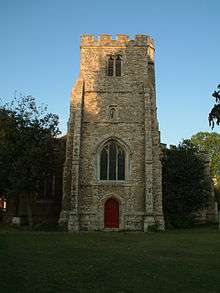
The mostly 15th-century church is located in Church Street. It is the oldest building in Edmonton.

Angel Place
A circa 1730 terrace of linked Grade II* Listed Buildings which were altered in the middle of the 19th century. 185, 187 and 189 were extensively restored in the 1980s to include the formation of an arch at 187 Angel Place with gardens behind. Set back from Fore Street, the A1010 road, and standing close to the junction with the A406 road, the buildings were adjacent to The Angel public house demolished to widen the North Circular Road.[25]

Charles Lamb Institute
The Grade II listed building is located in Church Street. Designed by J S Alder and opened in 1908. The building today is used as a church.[7]

Edmonton Central Library
The former public library (closed 1991) opened in 1897 at Fore Street. Designed by Maurice B Adams with bequests provided by the John Passmore Edwards foundation. Today the Grade II listed building is used as a religious and community centre. (Inside the library by the main entrance were two portrait plaques of Charles Lamb and John Keats by George Frampton, 1908. The plaques can be viewed at Community House, 313 Fore Street, Edmonton).[26]

Edmonton Federation Cemetery
The roughly triangular shaped Jewish cemetery was founded in 1889 with land given by Samuel Montagu.[27] The walled cemetery is bordered by Salmons Brook which forms part of the Pymmes Brook Trail and a footpath which follows the course of the disused Lower Edmonton low level railway.[28] Rabbi Eliezer Gordon is buried here. The cemetery contains the war graves of 7 Commonwealth service personnel of World War I and 23 of World War II.[29] The entrance is in Montagu Road B137 road. The site also incorporates the Western Synagogue Cemetery[27] founded in 1884 (containing 3 Commonwealth service war graves of World War II[30]) and adjoins the Tottenham Park Cemetery.[31][32]

Edmonton Girls' Charity School
The simple yellow brick structure with red brick dressings is located on the south side of Church Street. Initially the school, founded in 1784, had been on a different site. However the benefactor, Obadiah Legrew, grew tired of the children close to his home. He had the original school demolished, drew £170 from the trust, and purchased another plot of land. In 1793 the new school was built afresh, away from his delicate ears. Pupils aged between 7 and 14 were clothed and educated, although the main purpose was to fit them for domestic service. The facade carries a figure of a charity girl and the words A structure of Hope founded in Faith on the basis of Charity. The school closed in 1904.[33][34]

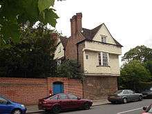
Lamb's Cottage
Formerly known as Bay Cottage. The cottage is believed to have been built in the 1680s and is located in the Church Street conservation area.[25] Writers Charles and Mary Lamb occupied the house between 1833–34, and is where Charles Lamb died.[35] The cottage was sold to its new owners in June 2008.[36]
The late 18th-century house has been used as a workhouse school, hospital and a refugee centre before closing in 1971. The house re-opened as an arts centre in 1979 in a complex which encompasses the Millfield Theatre, Millfield Arts Centre and the former Weir Hall Library (closed 2008).[37]
The hospital is located in Sterling Way, Upper Edmonton. Built in 1842 by the Edmonton Board of Guardians as the Edmonton Union Workhouse. A separate infirmary block was opened in 1910. Much of the building was taken over for use as a military hospital in 1915, during World War I, was returned to civilian use in 1920 and renamed The North Middlesex Hospital.[38]
Salisbury House
The house dates to the late 16th/early 17th century, and is the oldest building in Edmonton apart from All Saints' Church. The house which is located in Bury Street West, Lower Edmonton has been a private residence and a school before it was bought by Edmonton council in 1936. The building was established as an arts centre in 1957 (the first to be provided by a local authority in London).[39] In 1992 it underwent a major restoration. The house is Grade II listed along with some of the surrounding walls.[40]

The Crescent
A terrace of twenty five Georgian houses located in the Hertford Road. Built between 1826 and 1851 by a London solicitor. By the late 19th century the Crescent had been largely split into flats.[41][42]
Infrastructure
- Deephams Sewage Treatment Works is located near Picketts Lock
- Edmonton Incinerator the largest incinerator in the UK
- William Girling Reservoir is one of the reservoirs in the Lee Valley Reservoir Chain
Schools
Please see List of schools in the London Borough of Enfield.
Places of worship
- Edmonton Methodist Church. Located at 300 Fore Street, on the corner of Brettenham Road. There has been a Methodist church in Edmonton since the nineteenth century. The main part of the current building was erected in 1927.[43]
- Edmonton Baptist Church. Located close to Edmonton Green, a short walk from Edmonton railway station. Built in 1976.[44]
- All Saints' Church. A mainly 15th-century church located in Church Street.
- St Aldhelm's church. Is located in Silver Street Upper Edmonton. Built in 1903 and designed by William Douglas Caroe.[45]
- St Alphege's church. Was erected in 1958 and designed by Sir Edward Maufe. The church can be found at the junction of the Hertford Road and Galliard Road.[46]
- St Edmund's RC church. Built between 1905-1907 . The church is on the junction of the Hertford Road and Bounces Road.
- St. Mary with St. John's Church. Located on Dysons Road, close to the North Circular Road (A406), the church was built in 1906 together with a church hall and vicarage.[47]
- Saint Demetrios Greek Orthodox Church.[48] Located on the junction of Town Road and Logan Road. Greek Orthodox since 1977, formerly the Anglican Church of St. Martin.[49] The Church was built in 1909 and consecrated in 1911.[50]
- Mevlana Rumi Mosque. Located in Fore Street and opened in 2008 by the followers of Fethullah Gulen.[51]
- Silver Street Community Church. Located in Statham Grove, N18. Started in 2015 in partnership with Enfield Evangelical Free Church [52]
Shopping
The main shopping centre in Edmonton is at Edmonton Green which has a market, the second largest is at the Angel, Edmonton which is a high street containing a wide range of retail outlets.
Politics
The Member of Parliament for Edmonton is Kate Osamor, Labour Co-op who was elected at the General Election held on 5 May 2015.
The Boundary Commission review of 2011 proposes merging three Edmonton wards with most of the existing Chingford wards to create a new cross-Borough constituency of Chingford and Edmonton.[53]
Leisure and recreation
- Edmonton Cricket Club . The cricket club was founded in 1872 and is located in Church Street.[54] The ground is also home to the Norsemen football club.[55]
- Edmonton Leisure Centre located at Edmonton Green opened in August 2007. Facilities include a swimming pool and sports hall.[56]
- Lee Valley Leisure Complex located at Picketts Lock and is part of the Lee Valley Park
- Pymmes Brook Trail crosses Edmonton to join the Lea Valley Walk at Pickett's Lock on the River Lee Navigation.
- Angling is allowed upstream and downstream of Picketts Lock. Information from the River Lea Anglers Club.[57]
- The River Lee Navigation's towpath forms part of National Cycle Route 1 and the Lea Valley Walk.
Parks, gardens and open spaces
For further details see article Enfield parks and open spaces
- Bury Lodge gardens. The gardens are located in Bury Street West. Built on land belonging to Bury Lodge house (demolished 1935) and the nearby Salisbury House. The ornamental garden includes brick pillared pergolas, rose gardens and a pond. Other facilities are a playing field. The southern boundary of the park is bordered by Salmons Brook.[58][59]
- Churchfields Recreation Ground. The recreation ground is located close to the A10 in Lower Edmonton. The grounds facilities include playing fields and children's play area. The site is the home to London's only complete World War II Civil Defence Centre.[59][60]
- Craig Park TQ3448092570. The park is located in Upper Edmonton and lies close to Angel Road A406. Facilities include sports pitches, children's play area. and hardcourt.
- Jubilee Park. Covering 37 acres (150,000 m2) of land previously used for brick-making. The park opened on 24 June 1939 to commemorate King George V Silver Jubilee in 1935. Facilities include, the Henry Barrass stadium, formal gardens, pitch and putt, sports pitches, tennis courts and wildlife area.[61][62]
- Montagu Road Recreation Ground TQ3511193199. The recreation ground is located in Montagu Road B137. The facilities include playing fields, children's play area and hard courts.
- Plevna Road Open Space.Open space close to Edmonton Green
- Pymmes Park. This historic park is located in Upper Edmonton and borders the North Circular Road
- Tatem Park and Hollywood Gardens. The park and the gardens opened in 1938 and were built on a former gravel pit which belonged to the Tatem sisters, who donated the site to Edmonton Borough Council in the 1930s, for use as a public park. The gardens are named after Alderman Hollywood, former Mayor of Edmonton. The ornamental gardens occupy a triangle between two main roads A10 and the A111. In 1983 a nature area was created with the accent on wildlife conservation.[63]
Theatre and the arts
Edmonton is the home of the Millfield Arts Centre and Face Front Inclusive Theatre Company.[64]
Popular culture
- In an episode of BBC, television, comedy Some Mothers Do 'Ave 'Em Frank Spencer played by Michael Crawford roller skates down the now demolished bridge at Edmonton Green, and in the same episode he skates at the indoor rink at the now demolished Picketts Lock Centre.[65][66]
- The Empire Music Hall was the venue for Marie Lloyd's last stage performance in 1922. She was taken ill on stage and died several days later.[67]
- The video for the Lostprophets song Shinobi vs. Dragon Ninja was filmed in a car park at Edmonton Green.[68]
- Local musical duo Chas & Dave recorded a song titled Edmonton Green lamenting the changes that have occurred there.[69]
Watercourses
- River Lee Diversion
- River Lee Navigation
- Pymmes Brook
- Salmons Brook
- The Overflow Channel TQ3622492939 flows along the western perimeter of the William Girling reservoir to merge with the River Lee diversion, close to the Lea Valley Viaduct.
- Saddlers Mill Stream 51°37′19″N 0°02′55″W / 51.622°N 0.0485°W culverted throughout much of its course and flowing mostly underground. The stream was diverted in the early 21st century to alleviate flooding close to where it merges with Salmons Brook at Montagu Road.[70]
Nearest places
- Tottenham to the south
- Palmers Green to the west
- Chingford to the east
- Ponders End to the north
- Winchmore Hill to the north
Railway stations
Local newspapers
The local newspapers are as of 2011-
| Newspaper | Link |
|---|---|
| Enfield Independent | [71] |
| Enfield Advertiser | [72] |
References
- ↑ "Enfield Wards population 2011".
- ↑ Mills, A, D, Oxford Dictionary of London Place Names (2001) p74 ISBN 0-19-860957-4 Retrieved 19 October 2008
- ↑ "Volume 5: Hendon, Kingsbury, Great Stanmore, Little Stanmore, Edmonton Enfield, Monken Hadley, South Mimms, Tottenham (1976), pp. 172-175". 'Edmonton: Social life', A History of the County of Middlesex. British History Online. 1976. Retrieved 26 March 2010.
- ↑ Dalling, Graham (30 December 2005). "Lower Edmonton A History". History & Heritage. London Borough of Enfield. Archived from the original on 7 April 2010. Retrieved 26 March 2010.
- ↑ "History of Edmonton, in Enfield and Middlesex | Map and description". Visionofbritain.org.uk. Retrieved 2016-10-19.
- ↑ Short architectural description of the Town Hall Buildings of England pp425 London:4 North Bridget Cherry& Nikolaus Pevsner ISBN 0-14-071049-3 Retrieved 2 December 2007
- 1 2 "Church Street". Anidea.co.uk. Retrieved 2016-10-19.
- ↑ The poetical works of William Cowper, P 212,London: Frederick Warne and Co, 1892
- ↑ "324. The Diverting History of John Gilpin. William Cowper. 1909-14. English Poetry II: From Collins to Fitzgerald. The Harvard Classics". Bartleby.com. Retrieved 2016-10-19.
- ↑ "Clients". Krofire.comwebsitete=. Retrieved 2016-10-19.
- ↑ "Archived copy". Archived from the original on 25 August 2007. Retrieved 2007-07-19.
- 1 2 3 4 "Archived copy" (PDF). Archived from the original (PDF) on 10 April 2008. Retrieved 2008-02-26.
- ↑ "Edmonton Green - UK Census Data 2011". Ukcensusdata.com. Retrieved 2016-10-19.
- ↑ "Upper Edmonton - UK Census Data 2011". Ukcensusdata.com. Retrieved 2016-10-19.
- ↑ "Lower Edmonton - UK Census Data 2011". Ukcensusdata.com. Retrieved 2016-10-19.
- ↑
- ↑ "EU Migration to and from the UK - Migration Observatory - The Migration Observatory". Migrationobservatory.ox.ac.uk. Retrieved 2016-10-19.
- ↑ "Property Portfolio". St. Modwen. Retrieved 2016-10-19.
- ↑ Doyle, David (2010-10-14). "Travelodge to open at St Modwen's Edmonton Green | Online". Property Week. Retrieved 2016-10-19.
- ↑ "UK | England | London | Mayor launches youth action plan". BBC News. 2008-11-03. Retrieved 2016-10-19.
- ↑
- ↑ "Organisers pleased with Edmonton Peace March response (From Enfield Independent)". Enfieldindependent.co.uk. 2011-06-20. Retrieved 2016-10-19.
- ↑ "Latest news - Enfield Council". Enfield.gov.uk. Retrieved 2016-10-19.
- ↑ "Meridian Water in Enfield, is a £3.5bn investment opportunity". Meridianwater.co.uk. Retrieved 2016-10-19.
- 1 2 "Archived copy" (PDF). Archived from the original (PDF) on 10 April 2008. Retrieved 2008-03-29.
- ↑ "Archived copy". Archived from the original on 14 May 2008. Retrieved 2008-04-05.
- 1 2 "Archived copy". Archived from the original on 20 November 2008. Retrieved 2008-03-12.
- ↑ "Disused Stations: Lower Edmonton Low Level Station". Subbrit.org.uk. Retrieved 2016-10-19.
- ↑ "Cemetery Details". Cwgc.org. Retrieved 2016-10-19.
- ↑ "Cemetery Details". Cwgc.org. Retrieved 2016-10-19.
- ↑ "Parks and Open Spaces". Park Explorer. Retrieved 2016-10-19.
- ↑ "Archived copy" (PDF). Archived from the original (PDF) on 9 June 2011. Retrieved 2010-08-12.
- ↑ "Edmonton: Education | British History Online". British-history.ac.uk. 1931-11-30. Retrieved 2016-10-19.
- ↑ GodfreyA. (notes to) Old Ordnance Maps: London Sheet 1, Lower Edmonton 1894 Alan Godfrey Maps, ISBN 0-85054-966-3 Retrieved 8 April 2008
- ↑ "Archived copy". Archived from the original on 13 January 2009. Retrieved 2008-03-29.
- ↑ "5 bedroom house for sale in Lambs Cottage, Church Street, N9, N9". Rightmove.co.uk. Retrieved 2016-10-19.
- ↑ Dominic Gover (2008-12-23). "Lights go out on popular library (From This Is Local London)". Thisislocallondon.co.uk. Retrieved 2016-10-19.
- ↑ "Archived copy". Archived from the original on 2 October 2008. Retrieved 2008-03-31.
- ↑ "Edmonton: Social life | British History Online". British-history.ac.uk. Retrieved 2016-10-19.
- ↑ "Bury Street and Bush Hill Park". Anidea.co.uk. Retrieved 2016-10-19.
- ↑ Godfrey A. (notes to) Old Ordnance Survey Maps: London Sheet 2, Edmonton (Pickett's Lock) 1894 Alan Godfrey Maps, ISBN 0-85054-967-1 Retrieved 25 March 2008
- ↑ "Lower Edmonton - Hertford Road". Anidea.co.uk. Retrieved 2016-10-19.
- ↑ "Archived copy". Archived from the original on 24 June 2013. Retrieved 2013-02-08.
- ↑ "Archived copy". Archived from the original on 25 June 2009. Retrieved 2009-09-21.
- ↑ "Archived copy". Archived from the original on 3 April 2008. Retrieved 2008-03-29.
- ↑ "Lower Edmonton - Churches and Places of Worship". Anidea.co.uk. Retrieved 2016-10-19.
- ↑ "Facebook". Facebook. Retrieved 2016-10-19.
- ↑ "Saint Demetrios Greek Orthodox Church |". Saintdemetrios.org.uk. 1940-10-28. Retrieved 2016-10-19.
- ↑ "history". Stpetersedmonton.org.uk. Retrieved 2016-10-19.
- ↑ "Edmonton: Churches | British History Online". British-history.ac.uk. Retrieved 2016-10-19.
- ↑ "Archived copy". Archived from the original on 26 February 2010. Retrieved 2010-11-22.
- ↑ "About Us – Silver Street Community Church". Silverstreetchurch.org.uk. 2014-06-20. Retrieved 2016-10-19.
- ↑ "Initial proposals for new Parliamentary constituency boundaries published". Retrieved 13 September 2011.
- ↑ "Archived copy". Archived from the original on 27 March 2008. Retrieved 2008-04-07.
- ↑ "Archived copy". Archived from the original on 30 April 2008. Retrieved 2008-04-07.
- ↑ "Archived copy". Archived from the original on 6 February 2007. Retrieved 2007-02-16.
- ↑ "River Lea Anglers Club". Riverleaac.wix.com. Retrieved 2016-10-19.
- ↑ "Parks and Open Spaces". Park Explorer. Retrieved 2016-10-19.
- 1 2 "Lower Edmonton - Bury Lodge Park and Churchfields". Anidea.co.uk. Retrieved 2016-10-19.
- ↑ "Rsg: Sites: Site Name". Subbrit.org.uk. 2003-06-07. Retrieved 2016-10-19.
- ↑ "Archived copy". Archived from the original on 15 January 2009. Retrieved 2008-03-10.
- ↑ "Archived copy" (PDF). Archived from the original (PDF) on 10 April 2008. Retrieved 2008-03-10.
- ↑ "Parks and Open Spaces". Park Explorer. 1938-06-21. Retrieved 2016-10-19.
- ↑ "Face Front Inclusive Theatre". Facefront.org. Retrieved 2016-10-19.
- ↑ "Some Mothers Do 'Ave 'Em (1973–1978) : Trivia". IMDb.com. Retrieved 2016-10-19.
- ↑ "Rollerskating - Some Mothers Do 'Ave 'Em - BBC classic comedy". YouTube. 2007-06-15. Retrieved 2016-10-19.
- ↑ "Lower Edmonton - Leisure and Recreation". Anidea.co.uk. Retrieved 2016-10-19.
- ↑ "Archived copy". Archived from the original on 8 January 2008. Retrieved 2008-01-14.
- ↑ "Archived copy". Archived from the original on 24 July 2008. Retrieved 2008-04-10.
- ↑ "Lower Edmonton - Saddlers Mill Stream and the Boundary Ditch". Anidea.co.uk. Retrieved 2016-10-19.
- ↑ "News, sport and local information for Enfield, Edmonton, Palmers Green, Southgate, Winchmore Hill". Enfieldindependent.co.uk. Retrieved 2016-10-19.
- ↑ "Newspapers in the world - contacts, people and jobs". Mediauk.com. Archived from the original on 20 February 2011. Retrieved 2016-10-19.
Further reading
- An Edmonton Boy by Terry Webb ISBN 1-903981-00-X Published by Biograph 2000
- A Poacher's Tale told by A.T Curtis.Related by Fred J Speakman ISBN 0-7135-0969-4 Published by George Bell & Sons 1960
- The Diverting History Of John Gilpin by William Cowper
- Blackhole by Kevin Higgins poem published in collection The Boy With No Face Salmon Poetry 2005 ISBN 9781903392447 [1]
- The Veteran by Frederick Forsyth one of five short stories in the book of the same title Corgi 2002 ISBN 9780552149235
- "The National Gazetteer of Great Britain and Ireland" (1868) at Genuki, UK and Ireland Genealogy. (A brief description and history of Edmonton from the 1868 Gazetteer)
- A brief history of Lower Edmonton on the Enfield Council Website. (A succinct account starting early 1800s)
- Edmonton: Economic History from British history Online. (This is detailed and starts in 1086)
- Jackson, Alan A. (1999). London's Local Railways (2nd Edition). Capital Transport. ISBN 1-85414-209-7.
External links
| Wikimedia Commons has media related to Edmonton, London. |
- Lower Edmonton N9 Information
- Reports and Statistics for Edmonton and Enfield Borough
- Council Tax charges for Edmonton and Enfield Borough
- Edmonton in the early 1900s
- The Edmonton Greenist - first class images on the gallery
| Districts |
|  |
|---|---|---|
| Attractions | ||
| Parks and open spaces | ||
| Constituencies | ||
| Tube and rail stations | ||
| Other topics | ||