River Roch
| River Roch | |
| River | |
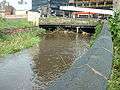 Flowing under one of the world's widest bridges | |
| Country | England |
|---|---|
| Districts | Littleborough, Rochdale, Heywood, Bury |
| Tributaries | |
| - left | Tack Lee Brook, Naden Brook, River Spodden, Hey Brook, Ash Brook, Featherstall Brook, Town House Brook |
| - right | Parr Brook, Hollins Brook, Wrigley Brook, Millers Brook, Sudden Brook, Moss Brook, Stanney Brook, River Beal, Ealees Brook, Greenvale Brook, Chelburn Brook |
| Source | |
| - location | Chelburn Moor |
| Mouth | |
| - location | River Irwell, Radcliffe |
| - coordinates | 53°33′43.95″N 2°18′2.65″W / 53.5622083°N 2.3007361°WCoordinates: 53°33′43.95″N 2°18′2.65″W / 53.5622083°N 2.3007361°W |
 | |
River Roch | ||||||||||||||||||||||||||||||||||||||||||||||||||||||||||||||||||||||||||||||||||||||||||||||||||||||||||||||||||||||||||||||||||||||||||||||||||||||||||||||||||||||||||||||||||||||||||||||||||||||||||||||||||||||||||||||||||||||||||||||||||||||||||||||||||||||||||||||||||||||||||||||||||||||||||||||||||||||||||||||||||||||||||||||||||||||||||||||||||||||||||||||||||||||||||||||||||||||||||||||||||||||||||||||||||||||||||||||||||||||||||||||||||||||||||||||||||||||||||||||||||||||||||||||||||||||||||||||||||||||||||||||||||||||||||||||||||||||||||||||||||||||||||||||||||||||||||
|---|---|---|---|---|---|---|---|---|---|---|---|---|---|---|---|---|---|---|---|---|---|---|---|---|---|---|---|---|---|---|---|---|---|---|---|---|---|---|---|---|---|---|---|---|---|---|---|---|---|---|---|---|---|---|---|---|---|---|---|---|---|---|---|---|---|---|---|---|---|---|---|---|---|---|---|---|---|---|---|---|---|---|---|---|---|---|---|---|---|---|---|---|---|---|---|---|---|---|---|---|---|---|---|---|---|---|---|---|---|---|---|---|---|---|---|---|---|---|---|---|---|---|---|---|---|---|---|---|---|---|---|---|---|---|---|---|---|---|---|---|---|---|---|---|---|---|---|---|---|---|---|---|---|---|---|---|---|---|---|---|---|---|---|---|---|---|---|---|---|---|---|---|---|---|---|---|---|---|---|---|---|---|---|---|---|---|---|---|---|---|---|---|---|---|---|---|---|---|---|---|---|---|---|---|---|---|---|---|---|---|---|---|---|---|---|---|---|---|---|---|---|---|---|---|---|---|---|---|---|---|---|---|---|---|---|---|---|---|---|---|---|---|---|---|---|---|---|---|---|---|---|---|---|---|---|---|---|---|---|---|---|---|---|---|---|---|---|---|---|---|---|---|---|---|---|---|---|---|---|---|---|---|---|---|---|---|---|---|---|---|---|---|---|---|---|---|---|---|---|---|---|---|---|---|---|---|---|---|---|---|---|---|---|---|---|---|---|---|---|---|---|---|---|---|---|---|---|---|---|---|---|---|---|---|---|---|---|---|---|---|---|---|---|---|---|---|---|---|---|---|---|---|---|---|---|---|---|---|---|---|---|---|---|---|---|---|---|---|---|---|---|---|---|---|---|---|---|---|---|---|---|---|---|---|---|---|---|---|---|---|---|---|---|---|---|---|---|---|---|---|---|---|---|---|---|---|---|---|---|---|---|---|---|---|---|---|---|---|---|---|---|---|---|---|---|---|---|---|---|---|---|---|---|---|---|---|---|---|---|---|---|---|---|---|---|---|---|---|---|---|---|---|---|---|---|---|---|---|---|---|---|---|---|---|---|---|---|---|---|---|---|---|---|---|---|---|---|---|---|---|---|---|---|---|---|---|---|---|---|---|---|---|---|---|---|---|---|---|---|---|---|---|---|---|---|---|---|---|---|---|---|---|---|---|---|---|---|---|---|---|---|---|---|---|---|---|---|---|---|---|---|---|---|---|---|---|---|---|---|---|---|---|---|---|---|---|---|---|---|---|---|---|---|---|---|---|---|---|---|---|---|---|---|---|---|---|---|---|---|---|---|---|---|---|---|---|---|---|---|---|---|---|---|---|---|---|
Legend
| ||||||||||||||||||||||||||||||||||||||||||||||||||||||||||||||||||||||||||||||||||||||||||||||||||||||||||||||||||||||||||||||||||||||||||||||||||||||||||||||||||||||||||||||||||||||||||||||||||||||||||||||||||||||||||||||||||||||||||||||||||||||||||||||||||||||||||||||||||||||||||||||||||||||||||||||||||||||||||||||||||||||||||||||||||||||||||||||||||||||||||||||||||||||||||||||||||||||||||||||||||||||||||||||||||||||||||||||||||||||||||||||||||||||||||||||||||||||||||||||||||||||||||||||||||||||||||||||||||||||||||||||||||||||||||||||||||||||||||||||||||||||||||||||||||||||||||
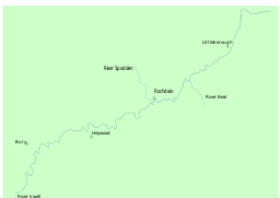
The River Roch /ˈroʊtʃ/ is a river in Greater Manchester in North West England, a tributary of the River Irwell that gives Rochdale its name.
Course
Rising on Chelburn Moor (south of Todmorden in the Pennines), the river flows south through Littleborough towards Rochdale where it is joined by the River Beal at Belfield, and the River Spodden from Whitworth. Turning west it runs past Heywood and Bury before meeting the River Irwell just to the east of Radcliffe.
History
The Domesday Book records the name of Rochdale as Recedham, formed from Old English reced "hall", and ham "homestead". The name of the river is a back-formation from this Old English name. With time, the town's name changed to Rachedale and eventually Rochdale.[1] The name of the river Roch is /ˈroʊtʃ/, with a long o. The name of the town, however, is pronounced /ˈrɒtʃdeɪl/, with a short o.
The river has been culverted in Rochdale town centre since the early 20th century. This was built by the joining together of seven bridges to form one large bridge, making it one of the widest bridges in the world. Maintenance work was carried out on the bridge in the 1990s and the river was uncovered temporarily.[2] In 2015 work began on opening the bridge again in a multi million pound project. On Boxing Day 2015, following heavy rain, the Roch burst its banks causing flooding in the town centre.[3]
Tributaries
Moving upstream from the Irwell confluence, the tributaries include the following:
- Parr Brook
- Hollins Brook
- Gigg Brook
- Barn Brook
- Green Brook
- Gipsy Brook [4]
- Tack Lee Brook
- Wrigley Brook
- Naden Brook
- Plumpton Wood Brook
- Millers Brook
- Primrose Hill Brook
- Sudden Brook
- River Spodden
- Moss Brook
- Hey Brook
- Stanney Brook
- River Beal
- Ash Brook
- Clegg Hall Brook
- Wuerdle Brook
- Stubley Brook
- Featherstall Brook
- Ealees Brook
- Town House Brook
- Greenvale Brook
- Chelburn Brook
Gallery
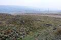 The source on Chelburn Moor
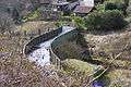 Aqueduct across the Caldervale Railway
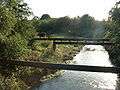 Looking downstream from Smallbridge
 Confluence of River Beal
- Flowing under one of the world's widest bridges
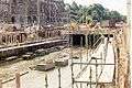 Rochdale town centre section uncovered during bridge works in the 1990s
 Confluence of River Spodden
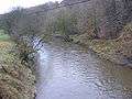 Upstream from Bottom o' th' Brow, Heywood
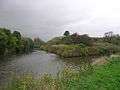 Confluence with River Irwell
References
- ↑ Mills, A.D.: A Dictionary of English Place Names, 2nd Edition, page 289, s.n. Rochdale. Oxford University Press, 1998
- ↑ Link4Life | Covering the River Roch in Rochdale | Provider of arts, sport and heritage development work in the Rochdale area
- ↑ http://www.bbc.co.uk/news/uk-35181139
- ↑ http://pad-planning.bury.gov.uk/DocExplorer/356/00/05/04/00050415.pdf