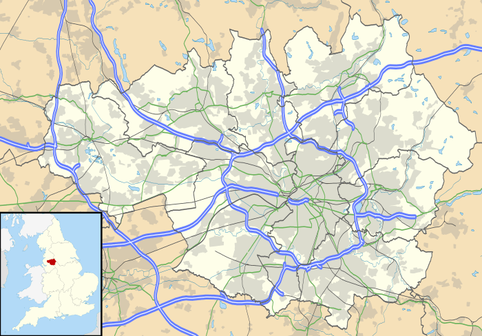
Swinton, Greater Manchester
| Swinton | |
.jpg) Salford Civic Centre, in Swinton |
|
 Swinton |
|
| Population | 25,362 (2011) |
|---|---|
| OS grid reference | SD775015 |
| – London | 167 mi (269 km) SE |
| Metropolitan borough | Salford |
| Metropolitan county | Greater Manchester |
| Region | North West |
| Country | England |
| Sovereign state | United Kingdom |
| Post town | MANCHESTER |
| Postcode district | M27 |
| Dialling code | 0161 |
| Police | Greater Manchester |
| Fire | Greater Manchester |
| Ambulance | North West |
| EU Parliament | North West England |
| UK Parliament | Salford and Eccles |
|
|
Coordinates: 53°30′44″N 2°20′28″W / 53.5122°N 2.3412°W
Swinton is a town in Greater Manchester, England.[1] Historically in Lancashire, it stands on gently sloping ground on the southwest side of the River Irwell, 3.4 miles (5.5 km) west-northwest of Salford, and 4.2 miles (6.8 km) west-northwest of Manchester, adjoining the towns of Pendlebury and Clifton. At the 2011 Census, Swinton had a population of 25,362.[2]
For centuries Swinton was a small hamlet in the township of Worsley, parish of Eccles and hundred of Salfordshire.[3] The name Swinton is derived from the Old English "Swynton" meaning "swine town".[3] In the High Middle Ages, Swinton was held by the religious orders of the Knights Hospitaller and Whalley Abbey. Farming was the main industry, with locals supplementing their incomes by hand-loom woollen weaving in the domestic system.[3]
Collieries opened in the Industrial Revolution and Swinton became an important industrial area with coal providing the fuel for the cotton spinning and brickmaking industries. Bricks from Swinton were used for industrial projects including the Bridgewater Canal, which passes Swinton to the south. The adoption of the factory system facilitated a process of unplanned urbanisation in the area, and by the mid-19th century Swinton was an important mill town and coal mining district at a convergence of factories, brickworks and a newly constructed road and railway network.[4]
Following the Local Government Act 1894, Swinton was united with neighbouring Pendlebury to become an urban district of Lancashire. Swinton and Pendlebury received a charter of incorporation in 1934, giving it honorific borough status. In the same year, the United Kingdom's first purpose-built intercity highway—the major A580 road (East Lancashire Road), which terminates at Swinton and Pendlebury's southern boundary—was officially opened by King George V.[5] Swinton and Pendlebury became part of the City of Salford in 1974. Swinton has continued to grow as the seat of Salford City Council and as a commuter town, supported by its transport network and proximity to Manchester city centre.
History
The name Swinton derives from the Old English swin, pigs and tun, an enclosure, farmstead or manor estate.[6] An early form was Swynton.[7]
During the Middle Ages, Swinton belonged to Whalley Abbey. Later, lands at Swinton were granted to Thurston Tyldesley, then of Wardley Hall. Documents record that certain areas belonged to the Knights Hospitaller.
In 1817 some Swinton weavers joined in the Blanketeers' demonstration and marched to London to put their grievances to the Prince Regent. In 1842 some Swinton people took part in Chartist agitations and tried to destroy a local colliery.
Sunday schools and libraries were established in Swinton at quite an early period. The Swinton Industrial School was visited by Charles Dickens. The school was created by the Manchester Poor Law Union. In contrast with other institutions for the poor around that time, which were places of final resort, the Swinton Industrial School was built in response to a more enlightened attitude. The Manchester Poor Law Union saw the value of a place where children could be cared for and educated.[8] The school opened in 1843 and survived until the 1920s. During demolition of the school buildings in the early 1930s, the foundations proved particularly difficult. Finally explosives were used, which resulted in a huge number of rats being disturbed. It was a number of weeks before council workers could remove the rats from the surrounding streets and houses. Huge nests of baby rats were carried out of the rafters of many buildings. The site was used for the present town hall.
Governance

Lying within the historic county boundaries of Lancashire since the early 12th century, Swinton anciently formed part of the hundred of Salford (civil jurisdiction). Swinton was a chapelry in the township of Worsley and ecclesiastical parish of Eccles.[1]
Swinton's first local authority was a local board of health established in 1867.[1] A regulatory body responsible for standards of hygiene and sanitation, it covered Swinton itself and the majority of the neighbouring township of Pendlebury. It changed its name to Swinton and Pendlebury Local Board of Health in 1869.[1] Following the Local Government Act 1894, Swinton became a civil parish, and the area of the local board became Swinton and Pendlebury, an urban district of the administrative county of Lancashire.[1] In 1907 there were exchanges of land with the neighbouring Worsley Urban District, and in 1933 most of Clifton and a part of Prestwich Urban District were added to Swinton and Pendlebury.[1] Swinton and Pendlebury received its Charter of Incorporation as a municipal borough from Edward Stanley, 18th Earl of Derby at a ceremony in Victoria Park on 29 September 1934.[1][10] In 1955 a very small part of Worsley Urban District was added to Swinton and Pendlebury.[1]
Under the Local Government Act 1972, the Municipal Borough of Swinton of Pendlebury was abolished, and Swinton has since 1 April 1974 formed an unparished area of the City of Salford, a metropolitan borough in the metropolitan county of Greater Manchester.[1][11]
Geography
 |
Kearsley | Clifton | Prestwich | |
| Worsley, Wardley | |
Pendlebury | ||
| ||||
| | ||||
| Eccles | Pendleton | Irlams o' th' Height |
Swinton lies at 53°30′44″N 2°20′28″W / 53.51222°N 2.34111°W (53.5122°, -2.3412°), 167 miles (269 km) northwest of central London, and 4.2 miles (6.8 km) west-northwest of Manchester city centre. Topographically, Swinton occupies an area of gently sloping ground, roughly 213 feet (65 m) above sea level,[12] and is on the south side of the River Irwell. Swinton lies in the west-central part of the Greater Manchester Urban Area,[13] the UK's second largest conurbation. The M60 motorway passes Swinton on its northwest side.
Landmarks

The architectural centrepiece of the town is the neoclassical Salford Civic Centre, which has a 125-foot (38 m) high clock tower.[14] It was built as Swinton and Pendlebury Town Hall, when Swinton and Pendlebury received its Charter of Incorporation. Before its construction, council meetings were held in Victoria House in Victoria Park, but the borough council required larger premises. A competition was launched to design the new town hall; the winners were architects Percy Thomas and Ernest Prestwich with a design that closely resembled Swansea Guildhall. It later won the RIBA Gold Medal.[15]
The site of the former Swinton Industrial School on Chorley Road was purchased for £12,500 and the foundation stone of the new town hall laid on 17 October 1936. The main builders were J. Gerrard's and Son of Pendlebury. The town hall opened on 17 September 1938. Extensions were built when it became the administrative headquarters of the City of Salford in 1974.
Wardley Hall is an early medieval manor house and a Grade I listed building, and is the official residence of the Roman Catholic bishops of Salford.[16]
Transport
Swinton is served by two railway stations on the Manchester to Southport Line. Swinton railway station is near the town centre on Station Road (B5231), just over the boundary in Pendlebury. The other station is Moorside near the top of Moorside Road, close to its junction with Chorley Road (A6). Until 1974 it was known as Moorside and Wardley.
Sports
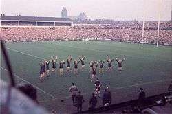
Swinton RLFC has an impressive record in rugby league considering the size of the town. The club's six Championship and three Challenge Cup wins is better than the record of their local rivals Salford RLFC. The club was based in the town until 1992, when financial mismanagement necessitated a move from the Station Road ground to play at Gigg Lane in Bury. The financial failure of main creditor and de facto owner Hugh Eaves in 2002 put the future of the club in jeopardy and it spent a short time regrouping at Moor Lane in Kersal, as tenants of Salford City F.C.. From 2003, the Lions played home games at Sedgley Park RUFC in Whitefield. In 2006, the club acquired land to build a 6,000 capacity stadium with training facilities and community use in Agecroft, Pendlebury. After ground-sharing with Leigh Centurions, Salford Red Devils and Widnes Vikings,[17] the club moved to Heywood Road, Sale for the 2016 season.
Swinton based junior association football side Deans F.C. was the starting point in the career of Ryan Giggs, who grew up in neighbouring Pendlebury and went on to become a Manchester United player, and also of Dean Holden.
Schools
Primary
- Mossfield Primary School, Mossfield Road, Newtown, Swinton
- St Peter’s C of E Primary School, Vicarage Road, Swinton
- St Mary’s RC Primary School, Milner Street, Swinton
- Broadoak Primary School, Fairmount Road, Swinton
- The Deans Primary School, Vicarage Road, Swinton
- Grosvenor Road Primary School, Parkgate Drive, Swinton
- Moorside Primary School, Holdsworth Street, Swinton
- St Charles' RC Primary School, Emlyn Street, Moorside, Swinton
- Springwood Primary School, Barton Road, Swinton
- Wardley C of E Primary School, Moss Bank Road, Wardley, Swinton
Secondary
- The Swinton High School, Sefton Road, Swinton
- Moorside High School, Deans Rd, Swinton
- St Ambrose Barlow RC High School & Sixth Form, Ash Drive, Swinton
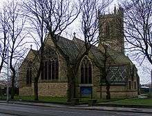
Churches
- St Peter’s C of E, Chorley Road, Swinton
- All Saints’ C of E, Charles Street, Swinton
- Holy Rood C of E, Moorside Road, Swinton
- St Mary’s RC, Park Street, Swinton
- St Charles’ RC, Moorside Road, Swinton
- United Reformed, Worsley Road, Swinton
- Worsley Road Methodist, Worsley Road, Swinton
- Latter-Day Saints, Partington Lane, Swinton
- Bethesda Hall, Worsley Road, Swinton
- Manchester Road Methodist, Manchester Road, Swinton
- Jehovah's Witnesses, Swinton Hall Road, Swinton
Notable people
Composer Sir Peter Maxwell Davies, previously Master of the Queen's Music, was brought up in Swinton after his family moved from Salford when he was four.[18] In 1998, he wrote Swinton Jig, an orchestral work inspired by the sounds and traditional melodies heard in Swinton during his childhood.[19]
The composer and pianist Roger Smalley was born in Swinton in 1943.[20]
See also
References
Notes
- 1 2 3 4 5 6 7 8 9 "Greater Manchester Gazetteer". Greater Manchester County Record Office. Places names - S. Archived from the original on 18 July 2011. Retrieved 8 October 2007.
- ↑ "Town population 2011". Retrieved 8 January 2016.
- 1 2 3 Cooper 2005, p. 137.
- ↑ Cooper 2005, p. 138.
- ↑ "Early Highways Liverpool-East Lancashire Road A580". Historic Highways. Lancashire County Council. Retrieved 19 January 2008.
- ↑ Mills 1976, p. 138
- ↑ "Swinton & Pendlebury - Local History, Salford City Council". Retrieved 6 August 2003.
- ↑ "Swinton Industrial School - how paupers were educated in 19th century Manchester". Retrieved 9 April 2012.
- ↑ R.D.W. Young (1998–2008). "Civic Heraldry of England and Wales - Lancashire (obsolete)". civicheraldry.co.uk. Retrieved 29 December 2008.
- ↑ ""Lifetimes Link: Issue 11 (July–December 2002) page 11", Magazine of Salford Museums & Heritage Service" (PDF). Retrieved 23 March 2008.
- ↑ HMSO. Local Government Act 1972. 1972 c.70.
- ↑ "Swinton, United Kingdom". Global Gazetteer, Version 2.1. Falling Rain Genomics, Inc. Retrieved 2 January 2008.
- ↑ Office for National Statistics (2001). "Census 2001:Key Statistics for urban areas in the North; Map 3" (PDF). statistics.gov.uk. Archived from the original (PDF) on 9 January 2007. Retrieved 9 July 2007.
- ↑ http://www.salford.gov.uk/council/councillors/mayor/civichistory/civiccentre.htm salford.gov.uk
- ↑ Salford City Council website Salford Civic Centre Updated 16 July 2010 (retrieved 2011-11-13)
- ↑ Salford Diocese, Salford Diocese, retrieved 16 July 2011
- ↑ "Swinton Lions return to Leigh Sports Village for 2014 season". Leigh Sports Village. Retrieved 11 January 2015.
- ↑ Moss, Stephen (19 June 2004). "Sounds and silence". The Guardian. London.
- ↑ Swinton Jig (on a Nineteenth Century Lancashire Fiddle Tune) for orchestra, maxopus.com
- ↑ http://www.rogersmalley.com/
Bibliography
- Cooper, Glynis (2005), Salford: An Illustrated History, The Breedon Books Publishing Company, ISBN 1-85983-455-8
- Mills, David (1976), The Placenames of Lancashire, Batsford, ISBN 0-7134-5236-6
External links
| Wikimedia Commons has media related to Swinton, Greater Manchester. |
- Salford City Council's history for Swinton
- Salford City Council's local information for Swinton
- Swinton and Pendlebury dedicated website
- Queensmere Heritage trail dedicated site