Rochester Township, Lorain County, Ohio
| Rochester Township, Lorain County, Ohio | |
|---|---|
| Township | |
|
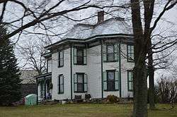
The Henry Bradford Farmhouse on State Route 511 | |
 Location of Rochester Township in Lorain County | |
| Coordinates: 41°6′32″N 82°18′1″W / 41.10889°N 82.30028°WCoordinates: 41°6′32″N 82°18′1″W / 41.10889°N 82.30028°W | |
| Country | United States |
| State | Ohio |
| County | Lorain |
| Area | |
| • Total | 17.6 sq mi (45.5 km2) |
| • Land | 17.6 sq mi (45.5 km2) |
| • Water | 0.0 sq mi (0.0 km2) |
| Elevation[1] | 942 ft (287 m) |
| Population (2000) | |
| • Total | 752 |
| • Density | 42.8/sq mi (16.5/km2) |
| Time zone | Eastern (EST) (UTC-5) |
| • Summer (DST) | EDT (UTC-4) |
| ZIP code | 44090 |
| Area code(s) | 440 |
| FIPS code | 39-67776[2] |
| GNIS feature ID | 1086518[1] |
Rochester Township is one of the eighteen townships of Lorain County, Ohio, United States. The 2000 census found 752 people in the township, 562 of whom lived in the unincorporated portions of the township.[3]
Geography
Located in southwestern Lorain County, it borders the following townships:
- Brighton Township - north
- Huntington Township - northeast corner
- Wellington Township - east
- Sullivan Township, Ashland County - southeast corner
- Troy Township, Ashland County - south
- Ruggles Township, Ashland County - southwest corner
- New London Township, Huron County - west
- Clarksfield Township, Huron County - northwest corner
The village of Rochester is located in northern Rochester Township.
Name and history
It is the only Rochester Township statewide.[4]
Government
The township is governed by a three-member board of trustees, who are elected in November of odd-numbered years to a four-year term beginning on the following January 1. Two are elected in the year after the presidential election and one is elected in the year before it. There is also an elected township fiscal officer, who serves a four-year term beginning on April 1 of the year after the election, which is held in November of the year before the presidential election. Vacancies in the clerkship or on the board of trustees are filled by the remaining trustees.
References
- 1 2 "US Board on Geographic Names". United States Geological Survey. 2007-10-25. Retrieved 2008-01-31.
- ↑ "American FactFinder". United States Census Bureau. Retrieved 2008-01-31.
- ↑ Lorain County, Ohio — Population by Places Estimates Ohio State University, 2007. Accessed 14 May 2007.
- ↑ "Detailed map of Ohio" (PDF). United States Census Bureau. 2000. Retrieved 2007-02-16.
External links
Municipalities and communities of Lorain County, Ohio, United States | ||
|---|---|---|
| Cities | 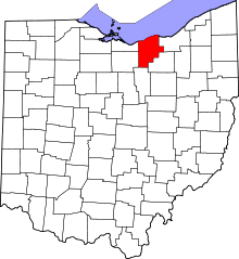 | |
| Villages | ||
| Townships | ||
| CDPs |
| |
| Unincorporated communities | ||
| Ghost town | ||
| Footnotes | ‡This populated place also has portions in an adjacent county or counties | |