Massachusetts Route 58
| ||||
|---|---|---|---|---|
 | ||||
| Route information | ||||
| Length: | 29.86 mi[1] (48.06 km) | |||
| Major junctions | ||||
| South end: |
| |||
| North end: |
| |||
| Location | ||||
| Counties: | Plymouth, Norfolk | |||
| Highway system | ||||
| ||||

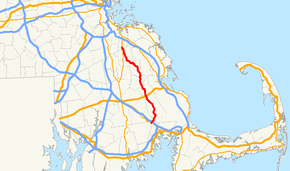
Route 58 is a south–north highway in southeastern Massachusetts. For all but its final 0.4 miles (0.64 km), the route lies within Plymouth County.
Route description
Route 58 begins at Route 28 on the Rochester–Wareham town line.[2][3] The route follows the town line for approximately a tenth of a mile before being wholly in Wareham. It then crosses I-495 before clipping the corner of Middleborough and re-entering Wareham for a short while before finally entering Carver. For the first 1.4 miles (2.3 km) of this route, none of the town line changes are signed.
The route turns northward through the town of Carver, passing Edaville Railroad and the King Richard's Faire grounds as well as the center of town. In North Carver the town intersects U.S. Route 44 just east of where that route becomes a four-lane freeway. Before the freeway was completed, the route had a short concurrency between its current exit ramps to Plymouth Road, where the route continued eastward to Plymouth. Route 58 then passes through the small town of Plympton and into Halifax, where it intersects Route 106. It then passes between the East and West Monponsett Ponds before crossing into Hanson.
In Hanson, Route 58 intersects Route 27 before sharing a 0.4 miles (0.64 km) concurrency with Route 14, passing the Town Hall and Wampatuck Pond before splitting northwestward. The route takes a few turns before entering Whitman, turning northward at a rotary into the town of Abington. It intersects Route 123, the Plymouth/Kingston commuter rail line, and Route 139, all before ending just over the Weymouth town line at Route 18, just west of the former South Weymouth Naval Air Station site.
Junction list
| County | Location | mi | km | Destinations | Notes | |
|---|---|---|---|---|---|---|
| Plymouth | Rochester | 0.00 | 0.00 | Southern terminus of Route 58 | ||
| Wareham | 0.4 | 0.64 | Exit 2 on I-495 | |||
| Carver | 10.3 | 16.6 | Interchange | |||
| Plympton | 12.3 | 19.8 | Mayflower Road | To Route 80 | ||
| Halifax | 15.8 | 25.4 | ||||
| Hanson | 19.4 | 31.2 | ||||
| 21.0 | 33.8 | Southern end of Route 14 concurrency | ||||
| 21.4 | 34.4 | Northern end of Route 14 concurrency | ||||
| Abington | 26.6 | 42.8 | ||||
| 28.0 | 45.1 | |||||
| Norfolk | Weymouth | 29.86 | 48.06 | |||
1.000 mi = 1.609 km; 1.000 km = 0.621 mi
| ||||||
See also
 Massachusetts portal
 U.S. Roads portal
References
- ↑ Office of Transportation Planning. "2007 Road Inventory". Executive Office of Transportation.
- ↑ Massachusetts Atlas & Gazetteer (Map). DeLorme. 2002. p. 58. § L9.
- ↑ American Map: Metro Boston-Eastern Massachusetts (Map). Arrow Map. 2004. p. 202. § A13.
External links
 Media related to Massachusetts Route 58 at Wikimedia Commons