Wareham, Massachusetts
| Wareham, Massachusetts | ||
|---|---|---|
| Town | ||
|
"Gateway to Cape Cod" | ||
| ||
 Location in Plymouth County in Massachusetts | ||
| Coordinates: 41°45′45″N 70°43′20″W / 41.76250°N 70.72222°WCoordinates: 41°45′45″N 70°43′20″W / 41.76250°N 70.72222°W | ||
| Country | United States | |
| State | Massachusetts | |
| County | Plymouth | |
| Settled | 1678 | |
| Incorporated | 1739 | |
| Government | ||
| • Type | Open town meeting | |
| Area | ||
| • Total | 46.3 sq mi (119.9 km2) | |
| • Land | 35.8 sq mi (92.7 km2) | |
| • Water | 10.5 sq mi (27.1 km2) | |
| Elevation | 20 ft (6 m) | |
| Population (2010) | ||
| • Total | 21,822 | |
| • Density | 470/sq mi (180/km2) | |
| Time zone | Eastern (UTC-5) | |
| • Summer (DST) | Eastern (UTC-4) | |
| ZIP code | 02571 | |
| Area code(s) | 508 / 774 | |
| FIPS code | 25-72985 | |
| GNIS feature ID | 0618353 | |
| Website | http://www.wareham.ma.us/ | |
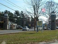
Wareham is a town in Plymouth County, Massachusetts, United States. As of the 2010 census, the town had a population of 21,822.[1]
The town of Wareham includes a number of distinct recognized subsections, including Onset, Wareham Center, West Wareham, East Wareham, and Weweantic.
History
Wareham was first settled in 1678 by Europeans as part of the towns of Plymouth and Rochester. It was officially incorporated in 1739 and named after the town of Wareham in England. Because of its geography, Wareham's early industry revolved around shipbuilding and the related industries. It also served as a resort town, with many smaller resorts scattered around the town, especially in Onset. Like Sandwich, its waterways, especially Buttermilk Bay, were considered as possible pathways for the Cape Cod Canal. Although the canal proper goes through Bourne and Sandwich, the southern approach to Buzzards Bay passes just south of the peninsulas that make up the topography of the town.
Wareham is home of the Tremont Nail Factory, the oldest nail manufacturer in the United States. The factory was established in 1819.
Geography
According to the United States Census Bureau, the town has a total area of 46.3 square miles (120 km2), of which 35.8 square miles (93 km2) is land and 10.5 square miles (27 km2) is water. The total area is 22.64% water. Wareham is bordered by Marion to the southwest, Rochester to the west, Middleborough to the northwest, Carver and Plymouth to the north, and Bourne to the east. The town's localities are numerous, the most important being East Wareham, Onset, Point Independence, Wareham Center, and West Wareham. The town is just west of Cape Cod, and is 18 miles (29 km) east of New Bedford, approximately 45 miles (72 km) east of Providence, Rhode Island and 55 miles (89 km) south-southeast of Boston.
Wareham is the innermost town on the north shore of Buzzards Bay. The Weweantic River empties in the southwest corner of town, with the Sippican River and other brooks emptying into it. The Wareham River, which is formed at the confluence of the Wankinco and Agawam rivers, flows into the harbor east of the Weweantic, and has brooks and the Mill Pond River as tributaries. To the east lie Onset Bay and Buttermilk Bay, both of which empty into the head of the bay, at the right-of-way of the Cape Cod Canal. Between these rivers and bays lie several points and necks, including Cromesett Point, Swift's Neck, Long Beach Point, Indian Neck, Stony Point, Cedar Island Point, Codman's Point, Sias Point and Whittemore's Point. The southern boundary of Myles Standish State Forest is concurrent with the town line between Wareham and Plymouth.
Demographics
| Historical population | ||
|---|---|---|
| Year | Pop. | ±% |
| 1850 | 3,186 | — |
| 1860 | 3,186 | +0.0% |
| 1870 | 3,098 | −2.8% |
| 1880 | 2,896 | −6.5% |
| 1890 | 3,451 | +19.2% |
| 1900 | 3,432 | −0.6% |
| 1910 | 4,102 | +19.5% |
| 1940 | 6,364 | +55.1% |
| 1950 | 7,569 | +18.9% |
| 1960 | 9,461 | +25.0% |
| 1970 | 11,492 | +21.5% |
| 1980 | 18,457 | +60.6% |
| 1990 | 19,232 | +4.2% |
| 2000 | 20,335 | +5.7% |
| 2010 | 21,822 | +7.3% |
| * = population estimate. Source: United States Census records and Population Estimates Program data.[2][3][4][5][6][7][8][9][10][11] | ||
As of the census[12] of 2000, there were 20,335 people, 8,200 households, and 5,338 families residing in the town. The population density was 568.1 people per square mile (219.3/km²). There were 10,670 housing units at an average density of 298.1 per square mile (115.1/km²). The racial makeup of the town was 87.42% White, 2.92% African American, 0.05% Pacific Islander, 5.20% from other races, and 3.43% from two or more races. 1.44% of the population were Hispanic or Latino of any race.
There were 8,200 households out of which 29.5% had children under the age of 18 living with them, 46.4% were married couples living together, 14.2% had a female householder with no husband present, and 34.9% were non-families. 29.2% of all households were made up of individuals and 12.6% had someone living alone who was 65 years of age or older. The average household size was 2.44 and the average family size was 3.02.
In the town the population was spread out with 24.5% under the age of 18, 6.3% from 18 to 24, 28.5% from 25 to 44, 24.5% from 45 to 64, and 16.2% who were 65 years of age or older. The median age was 39 years. For every 100 females there were 91.5 males. For every 100 females age 18 and over, there were 86.9 males.
The median income for a household in the town was $40,422, and the median income for a family was $45,750. Males had a median income of $37,601 versus $28,306 for females. The per capita income for the town was $21,312. 10.7% of the population and 8.1% of families were below the poverty line. 16.6% of those under the age of 18 and 13.5% of those 65 and older were living below the poverty line.
Economy
Today, Wareham is mostly residential, although it still has a strong summer tourism industry.[13] It has retail centers along Routes 6 and 28, including Wareham Crossing, opened in 2007.[14]
Historically, the cranberry industry has dominated Wareham's economy, as evidenced by the fact that the main local road is known as Cranberry Highway (Route 28) and one of the world's largest cranberry growers,[15] the A.D. Makepeace Company (a founder of the Ocean Spray growers' cooperative), is headquartered in Wareham. The University of Massachusetts Cranberry Research Station is also located in Wareham, as is the U.S. Department of Agriculture's Cranberry Marketing Committee.
Government
Wareham is represented in the Massachusetts House of Representatives as a part of the Second Plymouth district, which also includes Carver and part of Bourne. The town is represented in the Massachusetts Senate as a part of the First Plymouth and Bristol district, which also includes Berkley, Bridgewater, Carver, Dighton Marion, Middleborough, Raynham and Taunton.[16] The town is patrolled by the Seventh (Bourne) Barracks of Troop D of the Massachusetts State Police.[17]
On the national level, Wareham is part of Massachusetts's 9th congressional district and is currently represented by William R. Keating. Its senators are currently Elizabeth Warren and Ed Markey.
Wareham is governed by the open town meeting form of government, which is led by a town administrator and a board of selectmen.
There is a central police station located along Route 28. The Wareham Fire District (career/on-call) has stations located in Wareham Center (Station No.1, Manned Career/ on-call), East Wareham (Station No.4, Unmanned On-call), West Wareham (Station No. 2, Unmanned On-call) and in White Island, near Glen Charlie Pond (Station No.3, Unmanned On-call) in the northeast corner of town. The Onset Fire District (paid/on-call) has fire stations located in Onset Village and off Route 28/Cranberry Highway near the intersection of Main Avenue. Wareham EMS has a station located on Sandwich Road (Route 6).
There are four post offices for the town's four ZIP codes, located in East Wareham (02538), West Wareham (02576), Wareham Center (02571) and a branch office in Onset (02558). The southeast portion of Wareham is also covered by 02532 of Buzzards Bay. The town's public library, located across the street from the town hall, is part of the SAILS library network.
Education
Public schools
Wareham has a public school system. There are two elementary schools—John W. Decas and Minot Forest Elementary —serving the town; Wareham Middle School; and Wareham High School. The East Wareham Partnership houses the former West Wareham Academy and the Cooperative Junior-Senior High School.
Wareham High competes in the South Coast Conference for athletics. Its nickname is the Vikings, and its colors are Blue, White, and Gold. Wareham competes with Bourne High School in an annual Thanksgiving Day football game.
The town also sends students to Upper Cape Cod Regional Technical High School
High school students may also choose to attend Upper Cape Cod Regional Technical School in Bourne.
Private schools
There are no private schools in the town, with the nearest being Tabor Academy in Marion. The nearest Catholic high school is Bishop Stang High School in Dartmouth.
Transportation
Major highways
The town has always been a vital transportation point, as the Bay Colony Railroad crosses through the town on its way to Cape Cod. Interstates 495 and 195 both terminate in the western part of town, with I-495's highway route continuing on as Massachusetts Route 25, which passes through town and around Buttermilk Bay before ending at the Bourne Bridge. Additionally, U.S. Route 6 and Massachusetts Route 28 meet in East Wareham and continue on towards Cape Cod. Route 58's southern terminus is at Route 28 in Rochester near the Wareham town line.
Rail
There is currently no commuter rail service to Wareham, as the MBTA's Middleborough/Lakeville commuter rail line was only restored to Middleborough/Lakeville in 1997. The seasonal CapeFLYER service began stopping at Wareham Village station in June 2014.[18] Based on the success of the CapeFLYER, commuter service to Wareham and Buzzards Bay is under consideration.[19][20]
The nearest inter-city (Amtrak) passenger rail stations are Route 128, Providence, and Boston's South Station. The nearest MBTA commuter rail station is the Middleborough/Lakeville station.
Freight rail service is provided by the Massachusetts Coastal Railroad.
Bus
Bonanza Bus Lines stops at the Mill Pond Diner daily. A local bus service, the OWL (Onset Wareham Link), operated by the Greater Attleboro Taunton Regional Transit Authority (GATRA), provides bus service around Wareham. The buses also have run to a Tedeschi store in Bourne for connection to Bonanza Buses and to the MBTA's Middleborough/Lakeville Station. Service to these locations is often changed.
Air
The nearest national and international flights can be reached at Logan International Airport in Boston or T. F. Green Airport in Rhode Island. Barnstable Municipal Airport is also a short trip away, although it only allows for national service.
Sports
Wareham is home to the Wareham Gatemen, a collegiate summer baseball team and a member of the Western Division of the Cape Cod Baseball League. Wareham currently plays its home games at Clem Spillane Field.
Wareham has many town youth sports as well, including Wareham Little League, Wareham JBA, Gateway Babe Ruth, Pop Warner Wareham TIgers, Wareham Girls Softball (WGSA), and more.
Points of interest
- Tremont Nail Factory District, a historic nail factory located at 21 Elm Street, which operated from 1819 to 2006 by the Tremont Nail Company
- Water Wizz, water park in the area. Recently it was a spot of filming for the 2010 film Grown Ups and the 2013 film The Way, Way Back.
Notable people
- Stephen Cooper (b. 1979), NFL Football player for the San Diego Chargers
- Geena Davis (b. 1956), Academy Award and Golden Globe-winning actress
- Greg F. Gifune (b. 1963), Novelist, Editor
- Paul Fearing (1762–1822), a delegate to the U.S. House of Representatives from the Territory Northwest of the River Ohio
- John Kendrick (1740–1794), sea captain and explorer of the Pacific Northwest
- Eugene Thomas Maleska, (1916–1993) New York Times crossword puzzle editor, had a home in town
- Donald W. Nicholson, (1888–1968), congressman
- Pebbles (Susan L. Samedo, b. 1964), Boston radio personality
- Skipp Sudduth (b. 1956), actor
- Samuel T. Wellman (1847–1919), steel industry pioneer, industrialist, and prolific inventor
- Brandon Westgate (b. 1989), professional skateboarder
References
- ↑ "Profile of General Population and Housing Characteristics: 2010 Demographic Profile Data (DP-1): Wareham town, Plymouth County, Massachusetts". U.S. Census Bureau, American Factfinder. Retrieved March 22, 2012.
- ↑ "TOTAL POPULATION (P1), 2010 Census Summary File 1". American FactFinder, All County Subdivisions within Massachusetts. United States Census Bureau. 2010.
- ↑ "Massachusetts by Place and County Subdivision - GCT-T1. Population Estimates". United States Census Bureau. Retrieved July 12, 2011.
- ↑ "1990 Census of Population, General Population Characteristics: Massachusetts" (PDF). US Census Bureau. December 1990. Table 76: General Characteristics of Persons, Households, and Families: 1990. 1990 CP-1-23. Retrieved July 12, 2011.
- ↑ "1980 Census of the Population, Number of Inhabitants: Massachusetts" (PDF). US Census Bureau. December 1981. Table 4. Populations of County Subdivisions: 1960 to 1980. PC80-1-A23. Retrieved July 12, 2011.
- ↑ "1950 Census of Population" (PDF). Bureau of the Census. 1952. Section 6, Pages 21-10 and 21-11, Massachusetts Table 6. Population of Counties by Minor Civil Divisions: 1930 to 1950. Retrieved July 12, 2011.
- ↑ "1920 Census of Population" (PDF). Bureau of the Census. Number of Inhabitants, by Counties and Minor Civil Divisions. Pages 21-5 through 21-7. Massachusetts Table 2. Population of Counties by Minor Civil Divisions: 1920, 1910, and 1920. Retrieved July 12, 2011.
- ↑ "1890 Census of the Population" (PDF). Department of the Interior, Census Office. Pages 179 through 182. Massachusetts Table 5. Population of States and Territories by Minor Civil Divisions: 1880 and 1890. Retrieved July 12, 2011.
- ↑ "1870 Census of the Population" (PDF). Department of the Interior, Census Office. 1872. Pages 217 through 220. Table IX. Population of Minor Civil Divisions, &c. Massachusetts. Retrieved July 12, 2011.
- ↑ "1860 Census" (PDF). Department of the Interior, Census Office. 1864. Pages 220 through 226. State of Massachusetts Table No. 3. Populations of Cities, Towns, &c. Retrieved July 12, 2011.
- ↑ "1850 Census" (PDF). Department of the Interior, Census Office. 1854. Pages 338 through 393. Populations of Cities, Towns, &c. Retrieved July 12, 2011.
- ↑ "American FactFinder". United States Census Bureau. Retrieved 2008-01-31.
- ↑ "About Wareham". Town of Wareham. Retrieved June 11, 2011.
- ↑ "About Warehma Crossing". Retrieved June 11, 2011.
- ↑ "A.D. Makepeace Company : Inspired by Nature". admakepeace.com. Retrieved 2016-01-07.
- ↑ "Index of Legislative Representation by City and Town, from". Mass.gov. Retrieved 2012-09-05.
- ↑ Station D-7, SP Bourne Archived December 4, 2011, at the Wayback Machine.
- ↑ "New Wareham CapeFLYER Stop Opens" (Press release). Massachusetts Bay Transportation Authority. 26 June 2014. Retrieved 26 June 2014.
- ↑ Kinsella, James (16 August 2013). "Cape Commuter Rail Is A Real Possibility". Cape News. Retrieved 18 August 2013.
- ↑ "Chamber: Bring on commuter rail to Wareham, Buzzards Bay". Wicked Local Wareham. 25 September 2013. Retrieved 28 September 2013.
External links
| Wikimedia Commons has media related to Wareham, Massachusetts. |
| Wikivoyage has a travel guide for Wareham (Massachusetts). |
