Rush, Colorado
| Rush, Colorado | |
|---|---|
| Unincorporated community | |
|
Looking west down Highway 94, Pikes Peak is in the distance. | |
 Rush  Rush Location in El Paso County and the state of Colorado | |
| Coordinates: 38°50′45″N 104°5′32″W / 38.84583°N 104.09222°WCoordinates: 38°50′45″N 104°5′32″W / 38.84583°N 104.09222°W | |
| Country |
|
| State |
|
| County | El Paso County[1] |
| Elevation[1] | 6,017 ft (1,834 m) |
| Time zone | MST (UTC-7) |
| • Summer (DST) | MDT (UTC-6) |
| ZIP code | 80833[2] |
| Area code(s) | 719 |
| GNIS feature ID | 0193570 |

Rush is an unincorporated community and a U.S. Post Office located in El Paso County, Colorado, United States. The Rush Post Office has the ZIP Code 80833. [2]
Named for Christopher Rush, a homesteader from Missouri who settled there in 1907.[3]
Geography
Rush is located at 38°50′45″N 104°05′32″W / 38.84583°N 104.09222°W (38.845858,-104.092197), east of Yoder along State Highway 94 about 2 miles (3 km) west of the El Paso, Lincoln County line.
See also
References
- 1 2 "US Board on Geographic Names". United States Geological Survey. 2007-10-25. Retrieved 2008-01-31.
- 1 2 "ZIP Code Lookup" (JavaScript/HTML). United States Postal Service. January 2, 2007. Retrieved January 2, 2007.
- ↑ Bright, William (2004). Colorado Place Names. Johnson Books.
 Rush Colorado, looking east
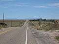 Pikes Peak from Rush, Colorado
Municipalities and communities of El Paso County, Colorado, United States | ||
|---|---|---|
| Cities | 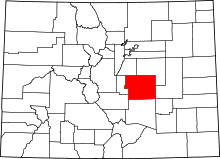 | |
| Towns | ||
| CDPs | ||
| Unincorporated communities | ||
| Footnotes | ‡This populated place also has portions in an adjacent county or counties | |
This article is issued from Wikipedia - version of the 7/31/2016. The text is available under the Creative Commons Attribution/Share Alike but additional terms may apply for the media files.