Truckton, Colorado
| Truckton, Colorado | |
|---|---|
| Unincorporated community | |
 Truckton Location within the state of Colorado | |
| Coordinates: 38°44′17″N 104°10′56″W / 38.73806°N 104.18222°WCoordinates: 38°44′17″N 104°10′56″W / 38.73806°N 104.18222°W | |
| Country | United States |
| State | Colorado |
| County | El Paso |
| Time zone | Mountain (MST) (UTC-7) |
| • Summer (DST) | MDT (UTC-6) |
| ZIP codes | 80864[1] |
| Area code(s) | 719[2] |
| GNIS feature ID | 193631 |
Truckton is an unincorporated community in El Paso County, Colorado, south of State Highway 94.[3]
References
- ↑ USPS.com
- ↑ allareacodes.com
- ↑ Official Colorado map
Municipalities and communities of El Paso County, Colorado, United States | ||
|---|---|---|
| Cities | 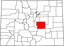 | |
| Towns | ||
| CDPs | ||
| Unincorporated communities | ||
| Footnotes | ‡This populated place also has portions in an adjacent county or counties | |

This article is issued from Wikipedia - version of the 1/25/2016. The text is available under the Creative Commons Attribution/Share Alike but additional terms may apply for the media files.