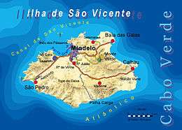
São Vicente, Cape Verde
| Native name: <span class="nickname" ">São Vicente, Son Visent, San Visent, Son Sent or São Sent Nickname: Ilha do Porto Grande (island of Porto Grande) | |
|---|---|
 | |
 | |
| Geography | |
| Location | Atlantic Ocean |
| Coordinates | 16°51′N 24°58′W / 16.850°N 24.967°W |
| Area | 227 km2 (88 sq mi) |
| Length | 24 km (14.9 mi) |
| Width | 16 km (9.9 mi) |
| Highest elevation | 725 m (2,379 ft) |
| Highest point | Monte Verde |
| Administration | |
|
Cape Verde | |
| Concelhos (Municipalities) | São Vicente |
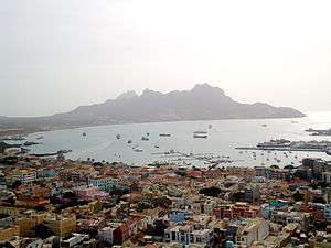
| Largest settlement | Mindelo |
| Demographics | |
| Population | 79,374 (2010) |
| Pop. density | 349.7 /km2 (905.7 /sq mi) |
São Vicente (Portuguese for "Saint Vincent"), also Son Visent or Son Sent in Cape Verdean Creole, is one of the Barlavento islands of Cape Verde. It is located between the islands of Santo Antão and Santa Luzia, with the Canal de São Vicente separating it from Santo Antão.
Geography
The island is roughly rectangular in shape with a surface area of ca. 227 square kilometres (88 square miles). From east to west it measures 24 kilometres (15 miles) and from north to south no more than 16 kilometres (9.9 miles). The terrain includes mountains in the west, the southwest, the south, the east-central and the north. The area is flat in the north-central, the central part, the eastern part south of Calhau and the northern part in the Baía das Gatas area. The urban area of Mindelo is in the northern part.
Although volcanic in origin, the island is quite flat. Its highest point is Monte Verde (Portuguese for green mountain) located in the northeast-central part with an altitude of 725 metres (2,379 feet). Although a great amount of erosion has taken place, some craters still remain — in particular near the bay of Mindelo. Other mountaintops include Monte Cara and Topona.
A small islet, called Ilheu dos Passaros, is located immediately at north of bay of Mindelo, less than one nautical mile from the coast
Up to the mid-20th century, trees were scarce in the island. Most of the island is deforested. The deforested parts of the island remains in the north, the east, the south and the westernmost portion. Most of the wide valleys have become forested along with its smaller dales particularly in the middle part.
Climate
São Vicente enjoys a very rare mild and dry tropical climate (classified as As according to Köppen's and Geiger's systematization), much akin to Santa Cruz de Tenerife or Las Palmas on the Canary Islands with only difference of being somewhat warmer during winter months. The average annual temperature in Mindelo is 23.2 °C (73.8 °F) which is exactly two degrees more than in Santa Cruz de Tenerife. Island is very arid with only 80 to 130 mm (3.15–5.12 inches) falling annually, somewhat higher only near the tops of the few mountains. These rare climate conditions are due to its position far off the west African coast and because Cape Verde are in the middle of cold Canary Current. The ocean water temperature every year is between 22 °C (72 °F) and 25 °C (77 °F). There are two seasons: December through July is mainly dry, cool and windy, while August through November is a wetter and warmer season.
| Climate data for Calhau, east of São Vicente, 10-40 metres ASL | |||||||||||||
|---|---|---|---|---|---|---|---|---|---|---|---|---|---|
| Month | Jan | Feb | Mar | Apr | May | Jun | Jul | Aug | Sep | Oct | Nov | Dec | Year |
| Average high °C (°F) | 23.0 (73.4) |
22.4 (72.3) |
23.2 (73.8) |
23.7 (74.7) |
24.1 (75.4) |
25.2 (77.4) |
26.7 (80.1) |
26.9 (80.4) |
26.3 (79.3) |
25.8 (78.4) |
25.8 (78.4) |
24.1 (75.4) |
24.8 (76.6) |
| Daily mean °C (°F) | 20.8 (69.4) |
20.5 (68.9) |
20.9 (69.6) |
21.3 (70.3) |
21.7 (71.1) |
23.0 (73.4) |
24.1 (75.4) |
24.7 (76.5) |
24.7 (76.5) |
24.3 (75.7) |
23.6 (74.5) |
22.1 (71.8) |
22.6 (72.7) |
| Average low °C (°F) | 18.7 (65.7) |
18.6 (65.5) |
18.7 (65.7) |
18.9 (66) |
19.4 (66.9) |
20.8 (69.4) |
21.5 (70.7) |
22.6 (72.7) |
23.2 (73.8) |
22.8 (73) |
21.5 (70.7) |
20.2 (68.4) |
20.6 (69.1) |
| Average precipitation mm (inches) | 5 (0.2) |
1 (0.04) |
1 (0.04) |
0 (0) |
0 (0) |
0 (0) |
4 (0.16) |
19 (0.75) |
67 (2.64) |
17 (0.67) |
10 (0.39) |
5 (0.2) |
129 (5.08) |
| Source: Climate-Data.ORG | |||||||||||||
Geographical features
In clockwise order:
- Ponta de Ribeira de Julião, in the northern part of the island
- Ponta de Coluna, in the northern part of the island
- Ponta de Salamansa, in the northern part of the island
- Ponta de Doca, in the northern part of the island
- Ponta Marigou, north, the northernmost point on the island
- Ponta da Fregata, in the northeastern part of the island
- Praia Grande (meaning large beach), northeast
- Ponta do Calhau, located in the east
- Ponta da Viana, located in the east
- Ponta de Saragaça, located in the east southeast
- Ponta da Várzea, located in the southeast
- Ponta do Matadouro, located in the south southeast
- Ponta da Calheta Grande, located in the east southeast
- Ponta do Sul, located in the south
- Ponta Araújo, in the south-southwestern part of the island
- Ponta da Ribeira da Caixa, in the southwestern part of the island
- Ponta da Botelha, in the northwestern part of the island
- Morro Branco, in the northwestern part of the island
- Ribeira Julião tributary
History
During the last Ice Age, the island was larger and compromised an estimate size of 1,500 km2 (579 sq mi) of land, the name of the island that included Santo Antão and Santa Luzia and two other islets was likely called the "Northwestern Island", a couple of thousands of years ago, flooding took place and broke up into three main islands and other islands, one became the current island of São Vicente.
São Vicente was discovered on Saint Vincent's Day (January 22) in 1462.[1] The island was originally granted to the Dukes of Viseu, the island was never populated, it remained inherited until it passed to Manuel I of Portugal.
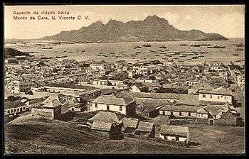
Due to its lack of water, the island was initially used only as a cattle pasture by some proprietors of the neighboring island of Santo Antão. Pirates arrived to the natural harbour for some times, for this, the fortification was built in 1734 to protect British, French and Dutch pirates. The island remained practically uninhabited until 1795 in the area of Porto Grande Bay and later the middle of the 19th century, the first name of the island's first settlement was Nossa Senhora da Luz, the first church on the island, the name is used as a parish area today, in 1819, the village was to be renamed to Leopoldinha after empress Maria Leopoldinha of Austria, wife of Peter IV of Portugal, it was not renamed until 1838 when they adopted the name Mindelo after a Portuguese military expedition that occurred in the beaches of Mindelo, Portugal during the Portuguese Civil War or the Wars of Liberation, rarely known as "Mindelo de São Vicente" today to outsiders. The British, Portugal's ally expanded most of the island's economy after Brazil declared independence in September 1822. It was only in 1838, when a coal deposit was established in Porto Grande to supply ships on Atlantic routes, that the population started to grow rapidly. It was the first island in Cape Verde to abolish slavery, São Nicolau and Santo Antão abolished it a year later. Telegraph lines, today known as communications lines established in 1874 by the Western Telegraph Company, via Madeira it connected with Recife, the capital of Pernambuco in Brazil, in 1886, it would connect other parts especially the southern and eastern parts of the British Empire, Portugal's ally. At the start of the 20th century, diesel ships appeared more and is usage as a coal deposit fell, later ships would use Dakar and the Canary Islands and the island economy declined, the hard hit years were after the Great Depression and the late 1940s, it caused a rise of the independence movement, the poor economy lasted until the time when Cape Verde became independent. The historic center of Mindelo has buildings from that date preserved into the present day. The Liceu Nacional Infante D. Henrique (now known as Escola de Jorge Barbosa), built in 1921 is out of colonial architecture, it had huge importance on the development of the rising nationalism of Cape Verde.
Due to the lack of rain and consequent lack of natural resources, the economy of São Vicente is based mainly on commerce and services.
Population
The population of São Vicente in the 2010 census was 79,374 of which 5,639 are rural. It is the second most populous island of Cape Verde. The annual population growth is around 1.3% (higher than the state (national) level of 1.2%). 92.6% of the population live in urban areas, higher than the Cape Verde's level of 61.8% and is the highest in all of Cape Verde. Life expectancy is 76 years, higher than some other parts of the world. The birth rate is 2.7% and infant mortality rate is 18 per 1000 live births[2] (for comparison 103 in DR Congo, 55 in India, 27 in Turkey, 23 in Brazil, 16 in Russia, 4 in Finland).
The population grew in the 19th century, it later slowed, the growth between 1950 and 1960 only added over a thousand, immigration affected the population, Between 1960 and 2010, the population nearly quadrupled, in the first ten years, the population grew more than 50% and reached over 30,000, the population today is now over 80,000.
The majority of the population is young; 66% of the population is under the age of 30, and 8.6% of the population is over the age of 60. The island has 16,000 families, of which there are an average of 3,6 persons per household, lower than Cape Verde's level of 3,9 persons per household. 56% of the families live in houses, the other 30% live in poorly built houses.
About only 11% of the families own automobiles, which is 7.4% of Cape Verde's level.
| Population of São Vicente, Cape Verde (1940—2010) | |||||||
|---|---|---|---|---|---|---|---|
| 1940[3] | 1950[3] | 1960[3] | 1970[3] | 1980[3] | 1990[3] | 2000[4] | 2010[4] |
| 15848 | 19576 | 20705 | 31578 | 41594 | 51277 | 67163 | 79374 |
Economy
The economy of the island was always based almost exclusively on commerce and services. Due to lack of rain, agriculture is at a subsistence level. Fishing has some relevance, but conditions prevent it from being more important, not only for the catch — lobster — but also for the associated industries: conserves, drying and salting of fish, and naval construction.
Porto Grande is the main port of Cape Verde, through which passes much of the country's imports. It has a terminal of containers, silos, and refrigeration units that make handling load overflow possible. There is also a modern seawater desalination plant, which provides water for public consumption and for naval shipyards.
In the industrial sector, the island presents an abundance of manpower, even though unskilled, resulting from the exodus of inhabitants of other islands to São Vicente. About 27% of the employed population is unskilled. Highly qualified employees — company executives, public administrators, and managers and directors — make up less than 2% of employees. It is distinguished, however, by a bigger participation of women in decision-making positions than the national average.
According to the 2010 census, the island of São Vicente has the largest unemployment rate of the country — 14,8% — while the national average is 11%. Unemployment affects women more than men. The industrial park of the island — the Industrial Zone of the Lazareto — concentrates diverse types of manufacturing, essentially due to foreign investment, in the activities of footwear, confections, and fish processing.
In recent years, the National Center of Workmanship of Mindelo supports local craftsmen in the production and commercialization of ceramic parts, articles made of coconut rinds, and necklaces of shells and rocks.
São Vicente has a great tradition in sports; from here many sports have spread to the remaining islands. Windsurfing, for example, relies on the excellent conditions here. The beach of São Pedro is considered one of the best for windsurfing, as shown by the many world-class champions of the sport. Cycling, walking trails and horseback riding are good ways to explore the island. The English influence on the island is still recognizable today in the golf: São Vicente has an excellent 18-hole golf course. For these reasons, tourism has excellent growth potential on São Vicente and in the rest of the Cape Verde archipelago. Travel between the diverse localities of the island is provided by a system of public transportation operated by five private companies: Transcor.SA, Morabeza Transport, Transport Joy, Friendship, Sotral and Automindelo. However, especially for places farthest from the city of the Mindelo, namely Baía das Gatas, Calhau, and São Pedro, van and bus leasing are the usual forms of transportation.
São Vicente has churches, a post office, a few banks, shops (not as many as Praia), a hospital named Baptista de Sousa and squares (praças)
Education
The literacy rate is 85%, and 98.9% among Cape Verdean youth. 54% of the island's population (those aged between 1 and 12 year old) receive education. Here are the schools and classrooms in São Vicente:
- Preschool - 25 daycares, the majority with a particular character, about 2,600 attendees between the ages of 1 and 6
- Primary Schools (1st year to 6th year) - 11,000 students in 225 classrooms with 379 teachers.
- Secondary Education (7th year to 12th year) - 8,000 students in 146 classrooms with 384 professors
Public: Liceu Ludjero Lima
Escola Industrial E Comercial Do Mindelo
Escola Secundária Jorge Barbosa
Escola Secundária José Augusto Pinto
Escola Salesiana
Private: Académica Do Mindelo
Wille
Centro Técnico Do Mindelo
Cooperativa Ensino Técnico Do Mindelo
Cruzeiro
- Post-Secondary Education -
Instituto Superior e Engenharia e Ciências
Universidade do Mindelo
Instituto Superior de Ciências Económicas Empresariais
Instituto Superior de Educação (pólo)
Universidade Jean Piaget de Cabo Verde (polo)
Mindelo Escolas Internacional de Artes
Universidade Lusófona
INDP Instituto Nacional de Desenvolvimento das Pescas and with it the Cape Verde Ocean Observatory CVOO
CVAO Cape Verde Atmospheric Observatory, associated with various universities and the cape verdian meteorological institute.
Language
Other than Portuguese which is the primary language, Cape Verdean Creole is mainly spoken by the majority of the population. The São Vicente variant is known as Crioulo de São Vicente (in Portuguese) or Kriol d Sonsent (in Creole).
Literature
- A Poética de Sérgio Frusoni - Uma Leitura Antropológica (Mesquitela Lima: Lisboa - 1992: Poeme im Kreol von São Vicente mit portugiesischer Übersetzung)
- Left-dislocation and topicalization in capeverdean creole. (Braga, Maria Luiza: Ph. D. Dissertation, University of Pennsylvania - 1982; Crioulo of São Vicente)
- Textos Crioulos Cabo-Verdianos - Sergio Frusoni (In 'Miscelânea luso-africana' 1975, herausgegeben von Marius F. Valkhoff)
Persons
- Carlos Alhinho, player and coach who lived in Portugal and Angola
- Alexandre Alhinho, player and coach
- Leonel Almeida, singer
- Dudu Araujo, a Capeverdean Singer
- Bana, a Cape Verdean singer
- Bau, a Cape Verdean musician
- B. Leza, singer and composer
- Valter Borges, footballer
- Bela Duarte, a Capeverdean artist
- Cesária Évora, a Capeverdean artist
- Fantcha, singer
- Sérgio Ferreira (1946-2006), writer
- Corsino Fortes (1933-2015), a Capeverdean writer
- Sergio Frusoni, A Capeverdean poet ()
- João Cleofas Martins, a Capeverdean photographer and a humorist
- Vasco Martins, a Capeverdean composer
- Georgina Mello, general director of CPLP nations
- Luís Ramos Morais, a Capeverdean artist
- Yolanda Morazzo (b. 1926), a Capeverdean poet and a fictionalist
- Tito Paris (b. 1968)
- Erin Pinheiro, footballer
- Rambé, footballer
- Onésimo Silveira, poet, diplomat and a political activist
- Ovídio de Sousa Martins, a Capeverdean poet
- Fredson (Fredson Tavares), footballer
- Carlos Veiga (b. October 21, 1949), a former Prime Minister of Cape Verde
- Lela Violão (Manuel Tomás da Cruz), a singer and a composer
Transportation
The island is connected with three major roads:
- Mindelo - São Pedro
- Mindelo - Calhau
- Mindelo - Baia das Gatas
The secondary routes include:
- From Mindelo - Calhau
- road to Madeira
- From Mindelo - Baia das Gatas
- road to Monde Verde
- road to Salamansa
References
- ↑ André Barbé (2002). Les îles du Cap-Vert. Harmattan. ISBN 9782747537308.
- ↑ "Statistics". Retrieved 16 October 2016.
- 1 2 3 4 5 6 Source: Statoids
- 1 2 Source: Instituto Nacional de Estatísticas.
External links
- Soncent - Li Ke Terra - Beautiful photos of the island and the people from São Vicente
- S. Vicente, Quel País - a description of São Vicente culture (Portuguese)
Coordinates: 16°51′N 24°58′W / 16.850°N 24.967°W
| Wikimedia Commons has media related to São Vicente, Cape Verde. |
| Island groups | ||
|---|---|---|
| Islands | ||
| Islets | ||