Ilhéu Rabo de Junco
| Geography | |
|---|---|
| Location | Atlantic Ocean |
| Coordinates | 16°42′00″N 22°59′35″W / 16.700°N 22.993°WCoordinates: 16°42′00″N 22°59′35″W / 16.700°N 22.993°W |
| Area | 0.02 km2 (0.0077 sq mi) |
| Length | 0.26 km (0.162 mi) |
| Width | 0.17 km (0.106 mi) |
| Highest elevation | 18 m (59 ft) |
| Administration | |
|
Cape Verde | |
| Municipality | Sal |
| Demographics | |
| Population | 0 |
Ilhéu Rabo de Junco is an uninhabited islet near the west coast of Sal Island, Cape Verde. It lies about 270 to 500 meters from the coast, its length is 253 meters long and 165 meters wide, its shoreline is about 878 m long.[1] It is the only islet next to the island of Sal. The island has been designated a protected area as a nature reserve[2] Baía da Murdeira is to the east, southeast of the islet, further east is the highest point in southern Sal named Monte Leão (the Lion Hill) elevating 165 meters.
The islet is a mountainous underwater volcano and was once connected to the rest of the island.
The total size is 1 ha.
References
- ↑ MAHOT Cartography, 2012
- ↑ "Protected areas of Cape Verde" (in Portuguese).
The island of Sal, Cape Verde | ||
|---|---|---|
| Settlements | 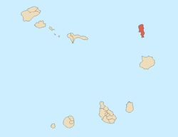 | |
| Parishes | ||
| Points and promontories | ||
| Lighthouses |
| |
| Other geographical features | ||
| Island groups | ||
|---|---|---|
| Islands | ||
| Islets | ||
This article is issued from Wikipedia - version of the 12/4/2016. The text is available under the Creative Commons Attribution/Share Alike but additional terms may apply for the media files.