Saint-Paul-les-Fonts
| Saint-Paul-les-Fonts | ||
|---|---|---|
|
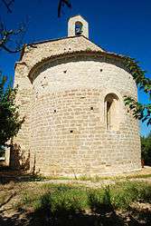
The Chapel of Saint-André de Sévanes | ||
| ||
 Saint-Paul-les-Fonts | ||
|
Location within Occitanie region  Saint-Paul-les-Fonts | ||
| Coordinates: 44°05′00″N 4°36′54″E / 44.0833°N 4.615°ECoordinates: 44°05′00″N 4°36′54″E / 44.0833°N 4.615°E | ||
| Country | France | |
| Region | Occitanie | |
| Department | Gard | |
| Arrondissement | Nîmes | |
| Canton | Bagnols-sur-Cèze | |
| Intercommunality | Val de Tave | |
| Government | ||
| • Mayor (2001–2008) | Marc Angeli | |
| Area1 | 5.46 km2 (2.11 sq mi) | |
| Population (2008)2 | 757 | |
| • Density | 140/km2 (360/sq mi) | |
| Time zone | CET (UTC+1) | |
| • Summer (DST) | CEST (UTC+2) | |
| INSEE/Postal code | 30355 / 30330 | |
| Elevation |
55–260 m (180–853 ft) (avg. 65 m or 213 ft) | |
|
1 French Land Register data, which excludes lakes, ponds, glaciers > 1 km² (0.386 sq mi or 247 acres) and river estuaries. 2 Population without double counting: residents of multiple communes (e.g., students and military personnel) only counted once. | ||
.svg.png)
Saint-Paul-les-Fonts is a commune in the Gard department in southern France.
Population
| Historical population | ||
|---|---|---|
| Year | Pop. | ±% |
| 1962 | 288 | — |
| 1968 | 324 | +12.5% |
| 1975 | 344 | +6.2% |
| 1982 | 403 | +17.2% |
| 1990 | 534 | +32.5% |
| 1999 | 610 | +14.2% |
| 2008 | 757 | +24.1% |
See also
References
| Wikimedia Commons has media related to Saint-Paul-les-Fonts. |
This article is issued from Wikipedia - version of the 11/9/2016. The text is available under the Creative Commons Attribution/Share Alike but additional terms may apply for the media files.