Saint-Victor-la-Coste
| Saint-Victor-la-Coste | ||
|---|---|---|
|
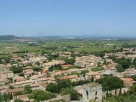
A general view of Saint-Victor-la-Coste | ||
| ||
 Saint-Victor-la-Coste | ||
|
Location within Occitanie region  Saint-Victor-la-Coste | ||
| Coordinates: 44°03′46″N 4°38′35″E / 44.0628°N 4.6431°ECoordinates: 44°03′46″N 4°38′35″E / 44.0628°N 4.6431°E | ||
| Country | France | |
| Region | Occitanie | |
| Department | Gard | |
| Arrondissement | Nîmes | |
| Canton | Roquemaure | |
| Intercommunality | Rhône Cèze Languedoc | |
| Government | ||
| • Mayor (2008–2014) | Robert Pizard-Deschamps | |
| Area1 | 26.64 km2 (10.29 sq mi) | |
| Population (2008)2 | 1,845 | |
| • Density | 69/km2 (180/sq mi) | |
| Time zone | CET (UTC+1) | |
| • Summer (DST) | CEST (UTC+2) | |
| INSEE/Postal code | 30302 / 30290 | |
| Elevation |
68–275 m (223–902 ft) (avg. 138 m or 453 ft) | |
|
1 French Land Register data, which excludes lakes, ponds, glaciers > 1 km² (0.386 sq mi or 247 acres) and river estuaries. 2 Population without double counting: residents of multiple communes (e.g., students and military personnel) only counted once. | ||
.svg.png)
Saint-Victor-la-Coste is a commune in the Gard department in southern France.
Built against a hill overlooking a plain covered with vineyards with the Rhone valley in the distance, the town was once part of the medieval domain of the Sabran family, vassals to the Count of Toulouse.
Population
| Historical population | ||
|---|---|---|
| Year | Pop. | ±% |
| 1962 | 775 | — |
| 1968 | 919 | +18.6% |
| 1975 | 951 | +3.5% |
| 1982 | 1,143 | +20.2% |
| 1990 | 1,285 | +12.4% |
| 1999 | 1,524 | +18.6% |
| 2008 | 1,845 | +21.1% |
Sights
Interesting sights include an 11th-century church and a 13th-century fort, known locally as Le Castellas, and which was restored by the French volunteer organization La Sabranenque.
Wine
There are several wineries in the village producing Côtes du Rhone wines.
See also
References
External links
| Wikimedia Commons has media related to Saint-Victor-la-Coste. |
This article is issued from Wikipedia - version of the 11/9/2016. The text is available under the Creative Commons Attribution/Share Alike but additional terms may apply for the media files.