St. Francis, Kansas
| St. Francis, Kansas | |
|---|---|
| County seat | |
|
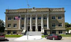
Cheyenne County Courthouse (2010) | |
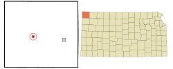 Location within Cheyenne County and Kansas | |
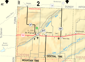 KDOT map of Cheyenne County (legend) | |
| Coordinates: 39°46′17″N 101°48′3″W / 39.77139°N 101.80083°WCoordinates: 39°46′17″N 101°48′3″W / 39.77139°N 101.80083°W | |
| Country | United States |
| State | Kansas |
| County | Cheyenne |
| Area[1] | |
| • Total | 0.87 sq mi (2.25 km2) |
| • Land | 0.87 sq mi (2.25 km2) |
| • Water | 0 sq mi (0 km2) |
| Elevation | 3,320 ft (1,012 m) |
| Population (2010)[2] | |
| • Total | 1,329 |
| • Estimate (2015)[3] | 1,304 |
| • Density | 1,500/sq mi (590/km2) |
| Time zone | Central (CST) (UTC-6) |
| • Summer (DST) | CDT (UTC-5) |
| FIPS code | 20-62175 [4] |
| GNIS feature ID | 0470970 [5] |
| Website | City website |
St. Francis is a city in and the county seat of Cheyenne County, Kansas, United States.[6] As of the 2010 census, the city population was 1,329.[7]
History
St. Francis was founded in 1887.[8][9] The city may have been named for the wife of its founder.[10]
Geography
St. Francis is located at 39°46′17″N 101°48′3″W / 39.77139°N 101.80083°W (39.771389, -101.800717).[11] According to the United States Census Bureau, the city has a total area of 0.87 square miles (2.25 km2), all of it land.[1]
Demographics
| Historical population | |||
|---|---|---|---|
| Census | Pop. | %± | |
| 1910 | 492 | — | |
| 1920 | 733 | 49.0% | |
| 1930 | 944 | 28.8% | |
| 1940 | 1,041 | 10.3% | |
| 1950 | 1,892 | 81.7% | |
| 1960 | 1,594 | −15.8% | |
| 1970 | 1,725 | 8.2% | |
| 1980 | 1,610 | −6.7% | |
| 1990 | 1,495 | −7.1% | |
| 2000 | 1,497 | 0.1% | |
| 2010 | 1,329 | −11.2% | |
| Est. 2015 | 1,304 | [3] | −1.9% |
| U.S. Decennial Census | |||
2010 census
As of the census[2] of 2010, there were 1,329 people, 650 households, and 357 families residing in the city. The population density was 1,527.6 inhabitants per square mile (589.8/km2). There were 768 housing units at an average density of 882.8 per square mile (340.9/km2). The racial makeup of the city was 98.2% White, 0.1% African American, 0.2% Native American, 1.1% Asian, 0.2% from other races, and 0.2% from two or more races. Hispanic or Latino of any race were 3.8% of the population.
There were 650 households of which 21.1% had children under the age of 18 living with them, 44.8% were married couples living together, 6.6% had a female householder with no husband present, 3.5% had a male householder with no wife present, and 45.1% were non-families. 42.5% of all households were made up of individuals and 24.7% had someone living alone who was 65 years of age or older. The average household size was 1.97 and the average family size was 2.67.
The median age in the city was 51.7 years. 18.7% of residents were under the age of 18; 5.1% were between the ages of 18 and 24; 17.8% were from 25 to 44; 26.8% were from 45 to 64; and 31.8% were 65 years of age or older. The gender makeup of the city was 48.9% male and 51.1% female.
2000 census
As of the census[4] of 2000, there were 1,497 people, 669 households, and 426 families residing in the city. The population density was 1,771.2 people per square mile (680.0/km²). There were 766 housing units at an average density of 906.3 per square mile (347.9/km²). The racial makeup of the city was 97.80% White, 0.20% African American, 0.07% Native American, 0.47% Asian, 0.07% Pacific Islander, 0.53% from other races, and 0.87% from two or more races. Hispanic or Latino of any race were 2.27% of the population.
There were 669 households out of which 25.3% had children under the age of 18 living with them, 54.7% were married couples living together, 6.7% had a female householder with no husband present, and 36.2% were non-families. 34.8% of all households were made up of individuals and 20.8% had someone living alone who was 65 years of age or older. The average household size was 2.16 and the average family size was 2.76.
In the city the population was spread out with 21.7% under the age of 18, 6.1% from 18 to 24, 21.9% from 25 to 44, 18.9% from 45 to 64, and 31.4% who were 65 years of age or older. The median age was 45 years. For every 100 females there were 91.2 males. For every 100 females age 18 and over, there were 83.4 males.
The median income for a household in the city was $30,842, and the median income for a family was $36,250. Males had a median income of $25,484 versus $19,167 for females. The per capita income for the city was $16,714. About 8.9% of families and 11.8% of the population were below the poverty line, including 18.3% of those under age 18 and 8.4% of those age 65 or over.
Climate
St. Francis experiences a semi-arid climate (Köppen BSk) with cold, dry winters and hot, wetter summers.
| Climate data for St. Francis, Kansas | |||||||||||||
|---|---|---|---|---|---|---|---|---|---|---|---|---|---|
| Month | Jan | Feb | Mar | Apr | May | Jun | Jul | Aug | Sep | Oct | Nov | Dec | Year |
| Record high °F (°C) | 81 (27) |
83 (28) |
92 (33) |
97 (36) |
103 (39) |
109 (43) |
111 (44) |
110 (43) |
105 (41) |
104 (40) |
89 (32) |
80 (27) |
111 (44) |
| Average high °F (°C) | 41.0 (5) |
47.1 (8.4) |
54.8 (12.7) |
64.4 (18) |
73.8 (23.2) |
85.7 (29.8) |
91.3 (32.9) |
89.3 (31.8) |
80.9 (27.2) |
69.2 (20.7) |
52.1 (11.2) |
43.5 (6.4) |
66.09 (18.94) |
| Daily mean °F (°C) | 27.2 (−2.7) |
32.4 (0.2) |
39.9 (4.4) |
49.2 (9.6) |
59.6 (15.3) |
70.8 (21.6) |
76.3 (24.6) |
74.2 (23.4) |
64.8 (18.2) |
52.2 (11.2) |
37.7 (3.2) |
29.5 (−1.4) |
51.15 (10.63) |
| Average low °F (°C) | 13.3 (−10.4) |
17.7 (−7.9) |
25.0 (−3.9) |
34.0 (1.1) |
45.3 (7.4) |
55.9 (13.3) |
61.3 (16.3) |
59.0 (15) |
48.6 (9.2) |
35.2 (1.8) |
23.3 (−4.8) |
15.5 (−9.2) |
36.18 (2.33) |
| Record low °F (°C) | −25 (−32) |
−25 (−32) |
−20 (−29) |
0 (−18) |
17 (−8) |
33 (1) |
41 (5) |
33 (1) |
18 (−8) |
3 (−16) |
−9 (−23) |
−31 (−35) |
−31 (−35) |
| Average precipitation inches (mm) | 0.51 (13) |
0.49 (12.4) |
1.17 (29.7) |
1.73 (43.9) |
3.14 (79.8) |
2.57 (65.3) |
2.97 (75.4) |
2.12 (53.8) |
1.16 (29.5) |
1.04 (26.4) |
0.76 (19.3) |
0.40 (10.2) |
18.06 (458.7) |
| Source #1: NOAA (normals, 1971–2000) [12] | |||||||||||||
| Source #2: The Weather Channel (Records) [13] | |||||||||||||
Notable people
- Ron Evans, astronaut
- Ray Stafford, Olympian
See also
- Burns, Kansas, was originally named St. Francis
References
- 1 2 "US Gazetteer files 2010". United States Census Bureau. Retrieved 2012-07-06.
- 1 2 "American FactFinder". United States Census Bureau. Retrieved 2012-07-06.
- 1 2 "Annual Estimates of the Resident Population for Incorporated Places: April 1, 2010 to July 1, 2015". Retrieved July 2, 2016.
- 1 2 "American FactFinder". United States Census Bureau. Retrieved 2008-01-31.
- ↑ "US Board on Geographic Names". United States Geological Survey. 2007-10-25. Retrieved 2008-01-31.
- ↑ "Find a County". National Association of Counties. Retrieved 2011-06-07.
- ↑ "2010 City Population and Housing Occupancy Status". U.S. Census Bureau. Retrieved March 6, 2011.
- ↑ Kansas State Historical Society (1916). Biennial Report of the Board of Directors of the Kansas State Historical Society. Kansas State Printing Plant. p. 159.
- ↑ Blackmar, Frank Wilson (1912). Kansas: A Cyclopedia of State History, Volume 2. Standard Publishing Company. p. 619.
- ↑ "Profile for Saint Francis, Kansas". ePodunk. Retrieved 6 June 2014.
- ↑ "US Gazetteer files: 2010, 2000, and 1990". United States Census Bureau. 2011-02-12. Retrieved 2011-04-23.
- ↑ "Climatography of the United States NO.81" (PDF). National Oceanic and Atmospheric Administration. Retrieved January 16, 2011.
- ↑ "Monthly Averages for St. Francis, KS". The Weather Channel. Retrieved January 16, 2011.
Further reading
- History of the State of Kansas; William G. Cutler; A.T. Andreas Publisher; 1883. (Online HTML eBook)
- Kansas : A Cyclopedia of State History, Embracing Events, Institutions, Industries, Counties, Cities, Towns, Prominent Persons, Etc; 3 Volumes; Frank W. Blackmar; Standard Publishing Co; 944 / 955 / 824 pages; 1912. (Volume1 - Download 54MB PDF eBook),(Volume2 - Download 53MB PDF eBook), (Volume3 - Download 33MB PDF eBook)
External links
| Wikimedia Commons has media related to St. Francis, Kansas. |
- City
- Schools
- USD 297, local school district
- Maps
- St. Francis City Map, KDOT
Municipalities and communities of Cheyenne County, Kansas, United States | ||
|---|---|---|
| Cities |  | |
| Unincorporated communities | ||
| Townships | ||