San Piero Patti
| San Piero Patti | |
|---|---|
| Comune | |
| Comune di San Piero Patti | |
 San Piero Patti Location of San Piero Patti in Italy | |
| Coordinates: 38°3′N 14°58′E / 38.050°N 14.967°ECoordinates: 38°3′N 14°58′E / 38.050°N 14.967°E | |
| Country | Italy |
| Region | Sicily |
| Province / Metropolitan city | Province of Messina (ME) |
| Area | |
| • Total | 41.6 km2 (16.1 sq mi) |
| Population (Dec. 2004) | |
| • Total | 3,378 |
| • Density | 81/km2 (210/sq mi) |
| Demonym(s) | Sampietrini |
| Time zone | CET (UTC+1) |
| • Summer (DST) | CEST (UTC+2) |
| Postal code | 98068 |
| Dialing code | 0941 |
| Website | Official website |
San Piero Patti (Sicilian: San Pieru Patti) is a comune (municipality) in the Province of Messina in the Italian region Sicily, located about 140 kilometres (87 mi) east of Palermo and about 50 kilometres (31 mi) southwest of Messina. As of 31 December 2004, it had a population of 3,378 and an area of 41.6 square kilometres (16.1 sq mi).[1]
San Piero Patti borders the following municipalities: Patti, Raccuja, Sant'Angelo di Brolo, Librizzi, Montalbano Elicona.
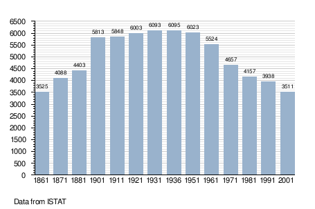
Demographic evolution
References
External links
This article is issued from Wikipedia - version of the 10/29/2015. The text is available under the Creative Commons Attribution/Share Alike but additional terms may apply for the media files.