Rodì Milici
"Rodì" redirects here. For other uses, see Rhodes and Rodi (disambiguation).
| Rodì Milici | |
|---|---|
| Comune | |
| Comune di Rodì Milici | |
|
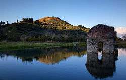
The Cupola Rosata | |
.svg.png) | |
 Rodì Milici Location of Rodì Milici in Italy | |
| Coordinates: 38°7′N 15°10′E / 38.117°N 15.167°ECoordinates: 38°7′N 15°10′E / 38.117°N 15.167°E | |
| Country | Italy |
| Region | Sicily |
| Province / Metropolitan city | Messina (ME) |
| Frazioni | Pietre Rosse, Case Bruciate, Porticato |
| Area | |
| • Total | 36 km2 (14 sq mi) |
| Elevation | 125 m (410 ft) |
| Population | |
| • Total | 2,335 |
| • Density | 65/km2 (170/sq mi) |
| Demonym(s) | Rodiesi (Rudioti), Milicioti |
| Time zone | CET (UTC+1) |
| • Summer (DST) | CEST (UTC+2) |
| Postal code | 98059 |
| Dialing code | 090 |
| Patron saint | Saint Batholomew, Saint Philip of Agira |
| Saint day | 24 August, 12 May |
Rodì Milici (Sicilian: Rudìa Milici) is an Italian comune in the Province of Messina in Sicily.
Geography
The comune is located about 160 kilometres (99 mi) east of Palermo and about 35 kilometres (22 mi) west of Messina. As of 31 December 2004, it had a population of 2,304 and an area of 36.1 square kilometres (13.9 sq mi).[1]
Rodì Milici borders the following municipalities: Antillo, Castroreale, Fondachelli-Fantina, Mazzarrà Sant'Andrea, Novara di Sicilia, Terme Vigliatore.
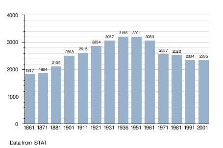
Demographic evolution
References
External links
![]() Media related to Rodì Milici at Wikimedia Commons
Media related to Rodì Milici at Wikimedia Commons
- View from Mt. Nicoletta (above Milici).
This article is issued from Wikipedia - version of the 3/19/2015. The text is available under the Creative Commons Attribution/Share Alike but additional terms may apply for the media files.