Sanbornville, New Hampshire
| Sanbornville, New Hampshire | |
|---|---|
| Census-designated place | |
|
Gafney Library | |
 Sanbornville  Sanbornville | |
| Coordinates: 43°33′15″N 71°1′51″W / 43.55417°N 71.03083°WCoordinates: 43°33′15″N 71°1′51″W / 43.55417°N 71.03083°W | |
| Country | United States |
| State | New Hampshire |
| County | Carroll |
| Town | Wakefield |
| Area | |
| • Total | 1.6 sq mi (4.1 km2) |
| • Land | 1.6 sq mi (4.1 km2) |
| • Water | 0.0 sq mi (0.0 km2) |
| Elevation | 581 ft (177 m) |
| Population (2010) | |
| • Total | 1,056 |
| • Density | 670/sq mi (260/km2) |
| Time zone | Eastern (EST) (UTC-5) |
| • Summer (DST) | EDT (UTC-4) |
| ZIP code | 03872 |
| Area code(s) | 603 |
| FIPS code | 33-67460 |
| GNIS feature ID | 0869768 |

Sanbornville is a census-designated place in the town of Wakefield in Carroll County, New Hampshire. It had a population of 1,056 at the 2010 census.[1]
The village is along New Hampshire Route 153 between its intersections with Route 125 and Route 16. It lies at the outlet of Lovell Lake.
References
- ↑ United States Census Bureau, American FactFinder, 2010 Census figures. Retrieved March 23, 2011.
Municipalities and communities of Carroll County, New Hampshire, United States | ||
|---|---|---|
| Towns | 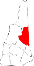 | |
| Township | ||
| CDPs | ||
| Other villages | ||
This article is issued from Wikipedia - version of the 7/10/2016. The text is available under the Creative Commons Attribution/Share Alike but additional terms may apply for the media files.