Intervale, New Hampshire
| Intervale, New Hampshire | |
|---|---|
| Unincorporated community | |
 Intervale  Intervale | |
| Coordinates: 44°04′36″N 71°08′21″W / 44.07667°N 71.13917°WCoordinates: 44°04′36″N 71°08′21″W / 44.07667°N 71.13917°W | |
| Country | United States |
| State | New Hampshire |
| County | Carroll |
| Towns | Bartlett, Conway |
| Elevation | 554 ft (169 m) |
| Time zone | Eastern (EST) (UTC-5) |
| • Summer (DST) | EDT (UTC-4) |
| ZIP code | 03845 |
| Area code(s) | 603 |
| GNIS feature ID | 872079[1] |
Intervale is an unincorporated community located on the boundary between the towns of Bartlett and Conway in the White Mountains of New Hampshire. The village is part of the Mount Washington Valley, a resort area that also includes the communities of North Conway and Jackson.
Intervale is found along U.S. Route 302 and New Hampshire Route 16 at their intersection with Hurricane Mountain Road, 1.5 miles (2.4 km) north of the center of North Conway. New Hampshire Route 16A leads north from Intervale through the village of Lower Bartlett. A state highway rest area with a fine view of Mount Washington and the Presidential Range is located along Routes 302 and 16 in Intervale.
The village has a separate ZIP code (03845) from surrounding communities in the Bartlett/Conway area.
References
Municipalities and communities of Carroll County, New Hampshire, United States | ||
|---|---|---|
| Towns | 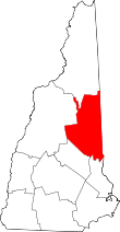 | |
| Township | ||
| CDPs | ||
| Other villages | ||