Sanchong District
| Sanchong 三重區 | |
|---|---|
| District | |
| Sanchong District | |
 | |
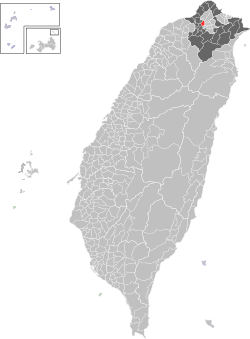 Sanchong District in New Taipei City | |
| Coordinates: 25°03′44″N 121°29′14″E / 25.06222°N 121.48722°ECoordinates: 25°03′44″N 121°29′14″E / 25.06222°N 121.48722°E | |
| Country | Taiwan |
| Special municipality | New Taipei |
| Established | 1947 |
| Area | |
| • Total | 16.3170 km2 (6.3000 sq mi) |
| Population (August 2016) | |
| • Total | 388,230 |
| • Density | 24,000/km2 (62,000/sq mi) |
| Time zone | CST (UTC+8) |
| Postal code | 241 |
| Area code(s) | 02 |
| Website |
www |
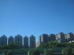
Sanchong District (Chinese: 三重區; pinyin: Sānchóng Qū; Pe̍h-ōe-jī: Sam-tiông-khu) is an inner city district in the western part of New Taipei City, Taiwan. With an area of 16.32 km² and a population of 384,618 people (2003), it has the fourth highest population density in Taiwan and 23rd in the world,[1] with over 23,900 people per km².
Geography
Sanchong is bounded to the north and northwest by Luzhou, Wugu, the west by Xinzhuang, and is separated from Taipei City by Tamsui River.
History
Sanchong was called Satengpo (Chinese: 三重埔; Pe̍h-ōe-jī: Saⁿ-têng-po͘ / Sam-tiông-po͘),[2] which literally means "The Third Plain" by the early settlers. The settlers from the modern-day Xinzhuang area moved up north and named the plains they settle as "The First Plain" (頭前埔, located in modern-day Xinzhuang District), "The Second Plain" (二重埔, located in modern-day Sanchong) and The Third Plain.
Republic of China
The district has been an important suburb of Taipei. On 1 April 1962, Sanchong was upgraded from an urban township to be a county-controlled city. On 25 December 2010 with the creation of New Taipei City from former Taipei County, Sanchong City was upgraded into a district.
Demography
As of October 2015, there were 388,550 people living in the district.[3]
The 2010 Population Census[4] reported that Sanchong has a population of 390,904. The population density was 24,172.6 inhabitants per square kilometer.
Education
Tourist attractions
- New Taipei Bridge
- Xianse Temple
- Erchong Riverside Park
- Erchong Lotus Park
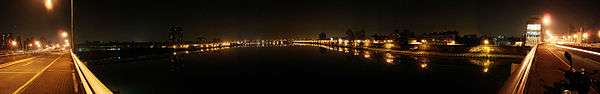
- Chongyang Bridge — a cable-stayed bridge and a beautiful night-time landmark
Shopping and eating
- Sanhe Nightmarket
- Carrefour Chongxin Shopping Mall
- B&Q Home Improvements, Hardware
- IKEA Home Furnishings Etc.
Transportation

The district is served by the Taipei Metro Luzhou Line (Line 4) at Sanchong Elementary School and Sanhe Junior High School, as well as Xinzhuang Line at Taipei Bridge, Cailiao, Sanchong, and Xianse Temple stations. The future Taoyuan Airport MRT will have a stop at Sanchong station.
By road, the district is accessible by National Highway No. 1, Provincial Highway No. 1 and No.1A, and Provincial Highway No. 64. The district is connected to Taipei City via Chongyang Bridge, Taipei Bridge, Zhongxiao Bridge, and Zhongxing Bridge. It is also connected to Xinzhuang, Luzhou, Wugu, and Banqiao.
Medical Facilities
| Name | Address | Services |
|---|---|---|
| Taipei County Hospital | No.2, Zhongshan Rd., Sanchong City, Taipei County 24141 Yingshi Rd., Banqiao City, Taipei County 22006 | Family Medicine; Internal Medicine; Surgery; Pediatrics; Obstetrics and Gynecology; Orthopedics; Neurology; Urology; E.N.T.; Ophthalmology; Dermatology; Psychiatry; Rehabilitation; Anesthesiology; X-ray (diagnosis); Pathology (anatomy); Emergency Medical Treatment; Dental; Chinese Medicine |
| Hong-Ren Hospital | 1 -4F ., No.186-196, Sec. 2, Sanhe Rd., Sanchong City, Taipei County 24149 | Internal Medicine; Orthopedics; Rehabilitation; Dental |
| Sanchong Jhong-Sing Hospital | No.21-, Zhongxing N. St., Sanchong City, Taipei County 24158 | Internal Medicine; Surgery |
| Tian-De-Tang Chinese Medical Hospital | No.3, Datong S. Rd., Sanchong City, Taipei County 24143 | Internal Medicine; Surgery; Ophthalmology; Pediatrics; Gynecology; Traumatology; Acupuncture |
| You-Min Hospital | No.2, Sec. 2, Chongsin Rd., Sanchong City, Taipei County 24147 | Family Medicine; Internal Medicine; Surgery; Pediatrics; Obstetrics and Gynecology; Orthopedics |
See also
| Wikimedia Commons has media related to Sanchong District, New Taipei. |
References
- ↑ List of cities proper by population density
- ↑ "Entry #40024 (三重埔)". 臺灣閩南語常用詞辭典 [Dictionary of Frequently-Used Taiwan Minnan] (in Chinese and Hokkien). Ministry of Education, R.O.C. 2011.
- ↑ http://www.ca.ntpc.gov.tw/Population/List?wnd_id=68
- ↑ http://ebas1.ebas.gov.tw/phc2010/english/rehome.htm
External links
- Government website (Chinese)
Districts of New Taipei | ||
|---|---|---|
City seat: Banqiao | ||
| Northern | 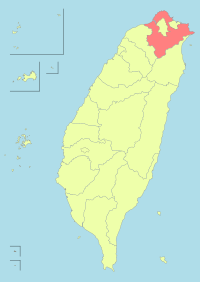 | |
| Eastern | ||
| Western | ||
| Southern | ||
| Mountain indigenous district | ||
Note: Although Hanyu Pinyin is the national standard, the municipal government endorses and uses "New Taipei" instead of "Xinbei" and "Tamsui" instead of "Danshui." | ||