Shulin District
| Shulin 樹林區 | |
|---|---|
| District | |
| Shulin District | |
 | |
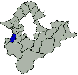 Shulin District in New Taipei City | |
| Coordinates: 24°59′N 121°25′E / 24.99°N 121.41°ECoordinates: 24°59′N 121°25′E / 24.99°N 121.41°E | |
| Country | Republic of China (Taiwan) |
| Special municipality | New Taipei City |
| Area | |
| • Total | 33.1288 km2 (12.7911 sq mi) |
| Population (January 2016) | |
| • Total | 184,329 |
| Time zone | +8 |
| Website | www.shulin.ntpc.gov.tw |
Shulin District (Chinese: 樹林區; pinyin: Shùlín Qū; Pe̍h-ōe-jī: Chhiū-nâ-chhī) is an inner city district in southwestern New Taipei City, Taiwan.[1]
Name
The area was named Shulin by the daily business commuters after seeing the sights of abundance of woods and trees in the region.
History
Shulin was upgraded to a county-controlled city of Taipei County on 4 October 1999 from a township, and to a district of New Taipei City on 25 December 2010.
Administrative divisions
Sanxing Village, Sanfu Village, Sanduo Village, Sanlong Village, Qiangliao Village, Guangxing Village, Jinliao Village, Tande Village, Wenlin Village, Baoan Village, Zunan Village, Zunfu Village, Zunmin Village, Zunsheng Village, Shude Village, Shufu Village, Shuxi Village, Shuxing Village, Shuren Village, Yuying Village, Shunan Village, Ponei Village, Shutung Village, Shubei Village, Pengfu Village, Heping Village, Pengxing Village, Pengcuo Village, Datong Village, Zhonghua Village, Taishun Village, Tungsheng Village, Tungyang Village, Tungshan Village, Shanjia Village, Zhongshan Village, Leshan Village, Ganyuan Village, Xiyuan Village, Nanyuan Village, Tungyuan Village, Beiyuan Village.
Transportation

See also
| Wikimedia Commons has media related to Shulin District, New Taipei. |
References
Districts of New Taipei | ||
|---|---|---|
City seat: Banqiao | ||
| Northern | 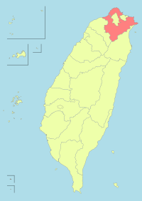 | |
| Eastern | ||
| Western | ||
| Southern | ||
| Mountain indigenous district | ||
Note: Although Hanyu Pinyin is the national standard, the municipal government endorses and uses "New Taipei" instead of "Xinbei" and "Tamsui" instead of "Danshui." | ||