Fuxing District, Taoyuan
| Fuxing 復興區 | |
|---|---|
| Mountain Indigenous District | |
| Fuxing District | |
 | |
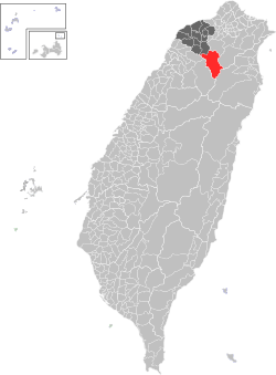 Fuxing District in Taoyuan City | |
| Country | Taiwan |
| Municipality | Taoyuan City |
| Boroughs |
List
|
| Government | |
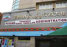
| • Type | District government |
| • District chief | Fan Cheng-hsin[1] (Ind.) |
| Population (January 2016) | |
| • Total | 10,932 |
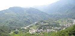
Fuxing District (Chinese: 復興區; pinyin: Fùxīng Qū), formerly known as Fuxing Township or Fu-Hsing Township (Chinese: 復興鄉; Hanyu Pinyin: Fùxīng Xiāng; Tongyong Pinyin: Fùsing Siang; Wade–Giles: Fu4-hsing1 Hsiang1) is a mountain indigenous district in eastern Taoyuan City, Taiwan. The main population is the Atayal people of the Taiwanese aborigines. Lalashan (拉拉山) is a major feature of Fuxing, and the Shimen Reservoir, formed by Shimen Dam, is a popular nearby site. Fuxing District is, by area, the largest district in Taoyuan City.
History
In August 2015, the Heliu community in the district were completely buried by landslide triggered by Typhoon Soudelor.[2]
Geography
- Area: 350.78 km²
- Population: 10,932 people (January 2016)
Administrative divisions
Sanmin Village, Zeren Village, Xiayun Village, Yicheng Village, Luofu Village, Zhangxing Village, Kuihui Village, Gaoyi Village, Sanguang Village, Hualing Village.
Mountains over 1500 metres
- Najieshan 那結山, 1520 m
- Mawangzenglushan 馬望曾呂山, 1577 m
- Niaozuishan 鳥嘴山, 1749 m
- Jianshan 興尖山, 1852 m
- Fufushan 夫婦山, 1870 m
- Meiguiximoshan 玫瑰西魔山, 1871 m
- Lengshan 稜山, 1889 m
- Lupaishan 魯培山, 1905 m
- Nanchatianshan 南插天山, 1907 m
- Lidongshan 李棟山, 1914 m
- Lalashan 拉拉山, 2030 m
- Tangsuishan 唐穗山, 2090 m
- Babokulushan 巴博庫魯山, 2101 m
- Tamanshan 塔曼山, 2130 m
- Dilushan 低陸山, 2160 m
- Yufengshan 玉峰山, 2300 m
- Siqiusishan 西丘斯山, 2427 m
- Xuebaishan 白的山, 2444 m
Northern Cross-Island Highway Hiking Trails
- 12.1 km > Sanmin Bat Cave...
- 16.3 km > Jiaobanshan, Jinpingshan...
- 17.7 km > Dongyanshan, Zhijishan...
- 20.7 km > Xiao Wulai > Hewei Ancient Trees, Beichatianshan, Nanchatianshan, Lupaishan, Daishifushan...
- 22.7 km > Luofu > Roma Rd.
- 28.2 km > Dawan > Najieshan...
- 31.1 km > Xuewu Tunnel > Fufushan...
- 39.9 km > Gaoyi > Yingshan...
- 46.5 km > Baling Bridge.
- 47.4 km > Galahe > Xuebaishan, Tangsuishan, Dilushan, Yufengshan, Siqiusishan...
- 47.8 km > Shang Baling > Lalashan Ancient Trees, Tamanshan, Meiguiximoshan, Baling-Fushan Trail...
- 59.3 km > Jianshan...
- 61.5 km > Lengshan
- 67.0 km > Mingchi > Babokulushan...
River Tracing
- Yunei River
- Xibuqiao River
- Sanguang River
- Taman River
Tourist attractions
- Jiguopai Old Church
- Dongyanshan National Forest Recreation Area
- Chatianshan Nature Reserve
- Lalashan Forest Reserve
- Xiao Wulai Scenic Area
- Jiaobanshan Sculpture Park
- Sanmin Bat Cave
Transportation
Zhongli Bus Co.
- Taoyuan Station 桃園 06:30 – Linbankou 林班口開 09:30
- Taoyuan Station 桃園 12:30 - Linbankou 林班口開 15:30
Taoyuan Bus Co.
- Taoyuan Station 桃園 06:50 - Linbankou 林班口開 09:50
- Zhongli Station 中壢 10:30 - Linbankou 林班口開 13:30
See also
| Wikimedia Commons has media related to Fuxing District, Taoyuan. |
References
External links
Districts of Taoyuan | ||
|---|---|---|
City seat: Taoyuan District | ||
| Districts |  | |
| Mountain indigenous district | ||
Taiwanese aboriginal areas | ||||||||||||||||||||||||||||||||||||||||||||||||
|---|---|---|---|---|---|---|---|---|---|---|---|---|---|---|---|---|---|---|---|---|---|---|---|---|---|---|---|---|---|---|---|---|---|---|---|---|---|---|---|---|---|---|---|---|---|---|---|---|
| Highland aboriginal Townships and Districts |
|  | ||||||||||||||||||||||||||||||||||||||||||||||
| Plains aboriginal Townships and County-Controlled Cities |
| |||||||||||||||||||||||||||||||||||||||||||||||
Note: On the map, "Highland aboriginal areas" are in green, and "Plains aboriginal areas" are in tan. | ||||||||||||||||||||||||||||||||||||||||||||||||
Coordinates: 24°49′22.18″N 121°21′6.27″E / 24.8228278°N 121.3517417°E