Heping District, Taichung
| Heping 和平區 | |
|---|---|
| Mountain Indigenous District | |
| Heping District | |
 | |
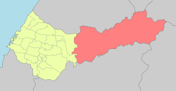 Heping District in Taichung City | |
| Coordinates: 24°16′00″N 121°09′00″E / 24.2666666667°N 121.15°ECoordinates: 24°16′00″N 121°09′00″E / 24.2666666667°N 121.15°E | |
| Country | Taiwan |
| Special municipality | Taichung |
| Boroughs |
List
|
| Government | |
| • Type | District government |
| • District chief | Lin Jian-tang (KMT) |
| Area | |
| • Land | 1,037.8192 km2 (400.7042 sq mi) |
| Population (January 2016) | |
| • Total | 10,707 |
| Website |
www |
Heping District (Chinese: 和平區; pinyin: Hépíng Qū; Wade–Giles: Ho2-p'ing2 Ch'ü1) is a mountain indigenous district in eastern Taichung, Taiwan, and it is the largest district of Taichung City. It is also the largest district in Taiwan by area. Heping is home to the Atayal people of the Taiwanese aborigines.
Geography
- Area: 1,037.82 square kilometres (400.70 sq mi)
- Population: 10,707 people (2016)
Economy
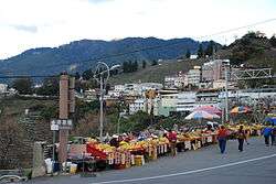
Native products of Heping District are apple, honey, vegetable, mountain fish, peach and bamboo.
Administrative divisions
Nanshi Village, Tianlun Village, Boai Village, Ziyou Village, Daguan Village, Zhongkeng Village, Lishan Village, Pingdeng Village.[1]
Infrastructures
Tourist attractions
- Baigu Mountain
- Dajian Mountain
- Dajia River
- Eight Immortals Mountain
- Guguan Hot Spring
- Kukuan Dam
- Ma'an Dam
- Mount Xue
- Qingshan Dam
- Techi Dam
- Tienlun Dam
- Wuling Farm
Transportation
The Provincial Highway 8 passes through Heping District to the east side of the island. On September 21, 1999, the 921 earthquake caused severe damage to the road, and is unlikely to be repaired. The section east of Guguan is now permanently closed to non-residents. Provincial Highway No. 14A now serves as an alternate route.
Notable natives
- Kao Chin Su-mei, member of Legislative Yuan
See also
| Wikimedia Commons has media related to Heping District, Taichung. |
References
Districts of Taichung | ||
|---|---|---|
City seat: Xitun | ||
| Urban area | .svg.png) | |
| Coastal area | ||
| Highland area | ||
| Mountain indigenous district | ||
Note: Although Hanyu Pinyin is the national standard; Central, East, South, West, and North District uses English instead. | ||
Taiwanese aboriginal areas | ||||||||||||||||||||||||||||||||||||||||||||||||
|---|---|---|---|---|---|---|---|---|---|---|---|---|---|---|---|---|---|---|---|---|---|---|---|---|---|---|---|---|---|---|---|---|---|---|---|---|---|---|---|---|---|---|---|---|---|---|---|---|
| Highland aboriginal Townships and Districts |
|  | ||||||||||||||||||||||||||||||||||||||||||||||
| Plains aboriginal Townships and County-Controlled Cities |
| |||||||||||||||||||||||||||||||||||||||||||||||
Note: On the map, "Highland aboriginal areas" are in green, and "Plains aboriginal areas" are in tan. | ||||||||||||||||||||||||||||||||||||||||||||||||