Sant'Ambrogio di Valpolicella
| Sant'Ambrogio di Valpolicella | ||
|---|---|---|
| Comune | ||
| Comune di Sant'Ambrogio di Valpolicella | ||
 | ||
| ||
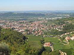
 Sant'Ambrogio di Valpolicella Location of Sant'Ambrogio di Valpolicella in Italy | ||
| Coordinates: 45°31′N 10°50′E / 45.517°N 10.833°E | ||
| Country | Italy | |
| Region | Veneto | |
| Province / Metropolitan city | Verona (VR) | |
| Frazioni | Domegliara, Ponton, Monte, San Giorgio, Gargagnago | |
| Government | ||
| • Mayor | Roberto Zorzi | |
| Area | ||
| • Total | 23.5 km2 (9.1 sq mi) | |
| Elevation | 174 m (571 ft) | |
| Population (1 August 2014[1]) | ||
| • Total | 11,700 | |
| • Density | 500/km2 (1,300/sq mi) | |
| Demonym(s) | Ambrosiani | |
| Time zone | CET (UTC+1) | |
| • Summer (DST) | CEST (UTC+2) | |
| Postal code | 37010 | |
| Dialing code | 045 | |
| Website | Official website | |

Sant'Ambrogio di Valpolicella is a comune (municipality) in the Province of Verona in the Italian region Veneto, located about 120 kilometres (75 miles) west of Venice and about 15 km (9 mi) northwest of Verona.
Sant'Ambrogio di Valpolicella borders the following municipalities: Cavaion Veronese, Dolcè, Fumane, Pastrengo, Pescantina, Rivoli Veronese, and San Pietro in Cariano.
Sights include the Romanesque pieve of San Giorgio, built in the 12th century over a Lombard (and perhaps pre-Roman) religious place. The interior has a nave and two aisles, of the same height, divided by piers. Some of the latter are decorated by 14th-century paintings. The basements of the columns are re-used Roman altars. The church houses also 11th-century frescoes, including a Last Supper; also notable is the ciborium, built during the reign of the Lombard king Liutprand (711-744). The bell tower and the cloister are also from the 12th century.
Twinning
Sant'Ambrogio is twinned with:
 Oppenheim, Germany
 Sant'Ambrogio di Torino, since 2004
- Sant'Ambrogio sul Garigliano, since 2004
 Sežana, Slovenia