Sona, Veneto
| Sona | |
|---|---|
| Comune | |
| Comune di Sona | |
|
Church | |
 Sona Location of Sona in Italy | |
| Coordinates: 45°26′N 10°50′E / 45.433°N 10.833°ECoordinates: 45°26′N 10°50′E / 45.433°N 10.833°E | |
| Country | Italy |
| Region | Veneto |
| Province / Metropolitan city | Verona (VR) |
| Frazioni | Lugagnano, Palazzolo, San Giorgio in Salici |
| Area | |
| • Total | 41.14 km2 (15.88 sq mi) |
| Elevation | 169 m (554 ft) |
| Population (2008)[1] | |
| • Total | 16,856 |
| • Density | 410/km2 (1,100/sq mi) |
| Demonym(s) | Sonesi |
| Time zone | CET (UTC+1) |
| • Summer (DST) | CEST (UTC+2) |
| Postal code | 37060 |
| Dialing code | 045 |
| Saint day | 6 August |
| Website | Official website |
Sona is a comune with 14 269 inhabitants in the province of Verona in Italy. It has an area of 41.14 square kilometres (15.88 square miles).
Twin towns
Sona is twinned with:

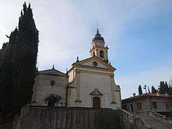
Church of Lugagnano
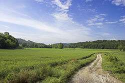
The moraine hills created by the glacier of Lake Garda during the last glaciation. Area between Sona and Sommacampagna

Lugagnano Fort, part of the Austro-Hungarian fortress of Verona, in 1863. Photo by Moritz Lotze (1809-1890)
References
External links
![]() Media related to Sona at Wikimedia Commons
Media related to Sona at Wikimedia Commons
This article is issued from Wikipedia - version of the 3/1/2016. The text is available under the Creative Commons Attribution/Share Alike but additional terms may apply for the media files.