Santiam Junction, Oregon
| Santiam Junction | |
|---|---|
| Unincorporated area locale | |
|
Highways at Santiam Junction | |
 Santiam Junction  Santiam Junction Location within the state of Oregon | |
| Coordinates: 44°26′12″N 121°56′22″W / 44.43667°N 121.93944°WCoordinates: 44°26′12″N 121°56′22″W / 44.43667°N 121.93944°W | |
| Country | United States |
| State | Oregon |
| County | Linn |
| Elevation | 3,750 ft (1,140 m) |
| Time zone | Pacific (PST) (UTC-8) |
| • Summer (DST) | PDT (UTC-7) |
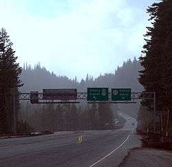
Santiam Junction is a highway junction and unincorporated community[1][2] in Linn County, Oregon, United States, at the intersection of U.S. Route 20/Oregon Route 126 and Oregon Route 22.
According to the Oregon Department of Transportation, the elevation is 3,750 feet (1,143 m).[3]
An automated weather station is located here, as well as highway maintenance facilities. The Santiam Junction State Airport is an emergency/recreational landing strip that is closed from the first snowfall until spring. The airport grounds permit fly-in camping.[3]
The Santiam Junction vicinity is listed by the National Register of Historic Places as the site of the Oregon Pacific Railroad Linear Historic District, which consists of roughly 20 miles (32 km) of the old railroad grade between Idanha and the line's Cascade Range summit.[4][5]
Geologically, much of the area is a lava bed created during a period of volcanic activity around 1000 B.C.[6]
Climate
Santiam Junction experiences a dry-summer humid continental climate (Köppen Dsb/Csb) with warm, dry summers and cold, wet winters with heavy snow and rain.
| Climate data for Santiam Junction | |||||||||||||
|---|---|---|---|---|---|---|---|---|---|---|---|---|---|
| Month | Jan | Feb | Mar | Apr | May | Jun | Jul | Aug | Sep | Oct | Nov | Dec | Year |
| Record high °F (°C) | 61 (16) |
67 (19) |
71 (22) |
88 (31) |
96 (36) |
95 (35) |
99 (37) |
99 (37) |
96 (36) |
86 (30) |
76 (24) |
60 (16) |
99 (37) |
| Average high °F (°C) | 37.8 (3.2) |
40.7 (4.8) |
44.3 (6.8) |
49.6 (9.8) |
59.2 (15.1) |
65.2 (18.4) |
76.4 (24.7) |
77.2 (25.1) |
71.4 (21.9) |
58.8 (14.9) |
44.4 (6.9) |
37.4 (3) |
55.2 (12.9) |
| Average low °F (°C) | 22.5 (−5.3) |
23.1 (−4.9) |
25.4 (−3.7) |
29.2 (−1.6) |
33.9 (1.1) |
38.2 (3.4) |
42.7 (5.9) |
41.3 (5.2) |
37.7 (3.2) |
32.4 (0.2) |
27.8 (−2.3) |
22.1 (−5.5) |
31.4 (−0.3) |
| Record low °F (°C) | −7 (−22) |
−18 (−28) |
0 (−18) |
4 (−16) |
18 (−8) |
22 (−6) |
28 (−2) |
28 (−2) |
21 (−6) |
14 (−10) |
2 (−17) |
−19 (−28) |
−19 (−28) |
| Average precipitation inches (mm) | 9.28 (235.7) |
6.66 (169.2) |
7.72 (196.1) |
5.74 (145.8) |
3.74 (95) |
2.37 (60.2) |
0.75 (19) |
0.73 (18.5) |
1.35 (34.3) |
4.1 (104) |
10.63 (270) |
9.06 (230.1) |
62.14 (1,578.4) |
| Average snowfall inches (cm) | 47.5 (120.7) |
39.5 (100.3) |
39.4 (100.1) |
15 (38) |
2.8 (7.1) |
0.3 (0.8) |
0 (0) |
0 (0) |
0.1 (0.3) |
4.8 (12.2) |
33.8 (85.9) |
57.6 (146.3) |
240.8 (611.6) |
| Average precipitation days | 17 | 14 | 19 | 16 | 12 | 8 | 3 | 3 | 5 | 10 | 20 | 16 | 143 |
| Source: [7] | |||||||||||||
See also
References
- ↑ "Feature Query Results". United States Board on Geographic Names, United States Geological Survey. Retrieved 2008-03-18.
- ↑ "Feature Class Types". Geographic Names Information System, United States Geological Survey. Archived from the original on 2008-02-15. Retrieved 2008-03-17.
- 1 2 "Santiam Junction". Department of Aviation State Warning Airports. Oregon Department of Transportation. Retrieved 2008-03-17.
- ↑ "Oregon Pacific Railroad Linear Historic District". OREGON - Marion County - Historic Districts. nationalregisterofhistoricplaces.com. Retrieved 2008-03-17.
- ↑ National Park Service (2010-07-09). "National Register Information System". National Register of Historic Places. National Park Service.
- ↑ Ellen Morris Bishop (2003). In Search of Ancient Oregon: A Geological and Natural History. Timber Press. ISBN 0-88192-590-X.
- ↑ "SANTIAM JUNCTION, OR (357554)". Western Regional Climate Center. Retrieved November 26, 2015.
External links
Municipalities and communities of Linn County, Oregon, United States | ||
|---|---|---|
| Cities | 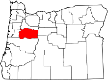 | |
| CDPs | ||
| Other unincorporated communities | ||
| Ghost towns | ||
| Footnotes | ‡This populated place also has portions in an adjacent county or counties | |