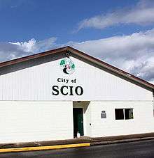
Scio, Oregon
| Scio, Oregon | |
|---|---|
| City | |
|
Storefronts on Main Street in Scio | |
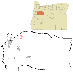 Location in Oregon | |
| Coordinates: 44°42′13″N 122°51′0″W / 44.70361°N 122.85000°WCoordinates: 44°42′13″N 122°51′0″W / 44.70361°N 122.85000°W | |
| Country | United States |
| State | Oregon |
| County | Linn |
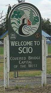
| Incorporated | 1866 |
| Government | |
| • Mayor | Gary C. Weaver |
| Area[1] | |
| • Total | 0.38 sq mi (0.98 km2) |
| • Land | 0.38 sq mi (0.98 km2) |
| • Water | 0 sq mi (0 km2) |
| Elevation | 317 ft (96.6 m) |
| Population (2010)[2] | |
| • Total | 838 |
| • Estimate (2012[3]) | 848 |
| • Density | 2,205.3/sq mi (851.5/km2) |
| Time zone | Pacific (UTC-8) |
| • Summer (DST) | Pacific (UTC-7) |
| ZIP code | 97374 |
| Area code(s) | 503 |
| FIPS code | 41-65650[4] |
| GNIS feature ID | 1126672[5] |

Scio (/ˈsaɪoʊ/ SEYE-oh) is a city in Linn County, Oregon, United States. The population was 838 at the 2010 census.[6]
History
Oregon Geographic Names suggests that Scio was named by one of the original residents, William McKinney, who, with Henry L. Turner, set up a flour mill at the new town. Turner suggested McKinney come up with a name for the place, and McKinney used the name of his former home, Scio, Ohio.
Scio in Ohio is, in turn named for a Greek island called Chios; the Italian version of the name is Scio.[7]
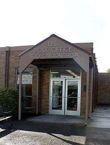
Scio post office, headed by postmaster Euphronius Wheeler, was established on October 3, 1860.[8]
Thomas Creek, which flows through the city, was named for Frederick Thomas, who obtained a Donation Land Claim and settled on the banks of the creek in 1846.[9]
Geography
According to the United States Census Bureau, the city has a total area of 0.38 square miles (0.98 km2), all land.[1]
Climate
This region experiences warm (but not hot) and dry summers, with no average monthly temperatures above 71.6 °F (22.0 °C). According to the Köppen Climate Classification system, Scio has a warm-summer Mediterranean climate, abbreviated "Csb" on climate maps.[10]
Demographics
| Historical population | |||
|---|---|---|---|
| Census | Pop. | %± | |
| 1870 | 400 | — | |
| 1880 | 193 | −51.7% | |
| 1890 | 253 | 31.1% | |
| 1900 | 346 | 36.8% | |
| 1910 | 295 | −14.7% | |
| 1920 | 300 | 1.7% | |
| 1930 | 258 | −14.0% | |
| 1940 | 351 | 36.0% | |
| 1950 | 448 | 27.6% | |
| 1960 | 441 | −1.6% | |
| 1970 | 447 | 1.4% | |
| 1980 | 579 | 29.5% | |
| 1990 | 623 | 7.6% | |
| 2000 | 695 | 11.6% | |
| 2010 | 838 | 20.6% | |
| Est. 2015 | 882 | [11] | 5.3% |
| source:[2][12] | |||
2010 census
As of the census[2] of 2010, there were 838 people, 306 households, and 225 families residing in the city. The population density was 2,205.3 inhabitants per square mile (851.5/km2). There were 324 housing units at an average density of 852.6 per square mile (329.2/km2). The racial makeup of the city was 91.4% White, 0.4% African American, 1.8% Native American, 0.6% Asian, 0.1% Pacific Islander, 2.0% from other races, and 3.7% from two or more races. Hispanic or Latino of any race were 3.1% of the population.
There were 306 households of which 35.9% had children under the age of 18 living with them, 52.3% were married couples living together, 14.7% had a female householder with no husband present, 6.5% had a male householder with no wife present, and 26.5% were non-families. 20.9% of all households were made up of individuals and 7.6% had someone living alone who was 65 years of age or older. The average household size was 2.74 and the average family size was 3.18.
The median age in the city was 34.8 years. 27.1% of residents were under the age of 18; 7.7% were between the ages of 18 and 24; 26.5% were from 25 to 44; 24.8% were from 45 to 64; and 14% were 65 years of age or older. The gender makeup of the city was 49.8% male and 50.2% female.
2000 census
As of the census[4] of 2000, there were 695 people, 265 households, and 188 families residing in the city. The population density was 2,202.6 people per square mile (838.6/km²). There were 278 housing units at an average density of 881.0 per square mile (335.4/km²). The racial makeup of the city was 93.24% White, 3.88% Native American, 0.43% Asian, 0.14% from other races, and 2.30% from two or more races. Hispanic or Latino of any race were 1.87% of the population.
There were 265 households out of which 35.5% had children under the age of 18 living with them, 54.7% were married couples living together, 10.6% had a female householder with no husband present, and 28.7% were non-families. 24.9% of all households were made up of individuals and 10.2% had someone living alone who was 65 years of age or older. The average household size was 2.61 and the average family size was 3.07.
In the city the population was spread out with 28.9% under the age of 18, 8.6% from 18 to 24, 24.6% from 25 to 44, 22.6% from 45 to 64, and 15.3% who were 65 years of age or older. The median age was 36 years. For every 100 females there were 84.8 males. For every 100 females age 18 and over, there were 81.0 males.
The median income for a household in the city was $36,111, and the median income for a family was $38,906. Males had a median income of $31,726 versus $27,833 for females. The per capita income for the city was $16,222. About 7.7% of families and 10.9% of the population were below the poverty line, including 11.8% of those under age 18 and 29.9% of those age 65 or over.
Points of interest
Scio refers to itself as the "Covered Bridge Capital of the West." There are five bridges as part of its Covered Bridge Tour[13] out of a total of eight in Linn County.[14]
Scio is also home to the ZCBJ Hall, a lodge built on beside Thomas Creek in 1922 by the large Czechoslovakian population then living in the area. Now owned by the Linn County Lamb and Wool Fair, the lodge is used for community events and rented out for private events such as weddings.[7]
References
- 1 2 "US Gazetteer files 2010". United States Census Bureau. Retrieved 2012-12-21.
- 1 2 3 "American FactFinder". U.S. Census Bureau. Retrieved December 4, 2014.
- ↑ "Population Estimates". United States Census Bureau. Retrieved 2013-06-02.
- 1 2 "American FactFinder". United States Census Bureau. Retrieved 2008-01-31.
- ↑ "US Board on Geographic Names". United States Geological Survey. 2007-10-25. Retrieved 2008-01-31.
- ↑ "Community Facts: Scio city, Oregon". United States Census Bureau. 2010. Retrieved 2014-12-04.
- 1 2 Scio, Asia Minor
- ↑ MacArthur, Lewis A. (1992). Oregon Geographic Names, 6th Ed.. Portland, Oregon: OHS Press. ISBN 0-87595-237-2.
- ↑ McArthur, Lewis A.; McArthur, Lewis L. Oregon Geographic Names. Portland, Oregon: Oregon Historical Society Press. p. 351.
- ↑ Climate Summary for Scio, Oregon
- ↑ "Annual Estimates of the Resident Population for Incorporated Places: April 1, 2010 to July 1, 2015". Retrieved July 2, 2016.
- ↑ Moffatt, Riley Moore (1996). Population History of Western U.S. Cities and Towns, 1850–1990. Lanham, Maryland: Scarecrow Press. p. 215. ISBN 978-0-8108-3033-2.
- ↑ "Scio Covered Bridge Tour". Retrieved 2012-07-29.
- ↑ "Covered Bridge Tour Route". Linn County Road Department. Retrieved 2012-07-29.
External links
| Wikimedia Commons has media related to Scio, Oregon. |
- Listing for Scio in the Oregon Blue Book
Municipalities and communities of Linn County, Oregon, United States | ||
|---|---|---|
| Cities |  | |
| CDPs | ||
| Other unincorporated communities | ||
| Ghost towns | ||
| Footnotes | ‡This populated place also has portions in an adjacent county or counties | |