Shalersville Township, Portage County, Ohio
| Shalersville Township | |
|---|---|
| Civil township | |
|
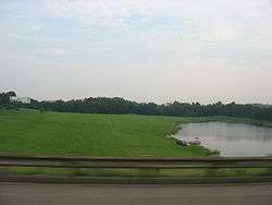
Countryside in western Shalersville Township | |
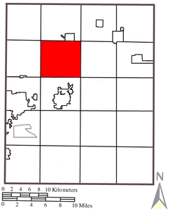 Location within Portage County | |
| Coordinates: 41°14′44″N 81°15′37″W / 41.24556°N 81.26028°WCoordinates: 41°14′44″N 81°15′37″W / 41.24556°N 81.26028°W | |
| Country | United States |
| State | Ohio |
| County | Portage |
| Area | |
| • Total | 27.6 sq mi (71.5 km2) |
| • Land | 27.5 sq mi (71.3 km2) |
| • Water | 0.1 sq mi (0.2 km2) |
| Elevation[1] | 1,119 ft (341 m) |
| Population (2010) | |
| • Total | 5,670 |
| • Density | 217.2/sq mi (83.9/km2) |
| Time zone | Eastern (EST) (UTC-5) |
| • Summer (DST) | EDT (UTC-4) |
| ZIP code | 44255, 44266, 44241 |
| Area code(s) | 330, 234 |
| FIPS code | 39-71731[2] |
| GNIS feature ID | 1086839[1] |
Shalersville Township is one of the eighteen townships of Portage County, Ohio, United States. The 2010 census found 5,670 people in the township.[3]
Geography
Located in the northwestern part of the county, it borders the following other townships and cities:
- Mantua Township - north
- Hiram Township - northeast corner
- Freedom Township - east
- Charlestown Township - southeast corner
- Ravenna Township - south
- Franklin Township - southwest corner
- Streetsboro - west
- Aurora - northwest corner
No municipalities are located in Shalersville Township.
Formed from the Connecticut Western Reserve, Shalersville Township covers an area of 28 sq mi (73 km2).
Historic population figures
- 1960—2,823
- 1970—4,967
- 1980—5,268
- 1990—5,270
- 2000—5,976
- 2010—5,670
Name and history
Shalersville takes its name from its original proprietor, General Nathaniel Shaler and was originally known as "Middletown" as Shaler was a native of Middletown, Connecticut.[4] It is the only Shalersville Township statewide.[5] The first settlers, the family of Joel Baker of Tolland County, Connecticut, arrived in 1806 and the township government was organized in 1812. The township was formed from town 4, range 8 of the Connecticut Western Reserve.[6] A post office called Shalersville was established in 1824, and remained in operation until 1904.[7]
Government
The township is governed by a three-member board of trustees, who are elected in November of odd-numbered years to a four-year term beginning on the following January 1. Two are elected in the year after the presidential election and one is elected in the year before it. There is also an elected township fiscal officer,[8] who serves a four-year term beginning on April 1 of the year after the election, which is held in November of the year before the presidential election. Vacancies in the fiscal officership or on the board of trustees are filled by the remaining trustees.
Transportation
Ohio State Routes 303 and 44 pass through Shalersville and intersect at the middle of the township. The Ohio Turnpike also cuts through Shalersville, and in the 1990s the exit at State Route 44 was added. The Portage County Airport is located in the southern part of the township.
Notable residents
- Bernie Kosar, former Cleveland Browns quarterback.
References
- 1 2 "US Board on Geographic Names". United States Geological Survey. 2007-10-25. Retrieved 2008-01-31.
- ↑ "American FactFinder". United States Census Bureau. Retrieved 2008-01-31.
- ↑ Portage County, Ohio — Population by Places Estimates Ohio State University, 2007. Accessed 15 May 2007.
- ↑ History of Portage County, Ohio: Containing a History of the County, Its Townships, Towns, Villages, Schools, Churches, Industries, Etc. Warner, Beers & Company. 1885. p. 552.
- ↑ "Detailed map of Ohio" (PDF). United States Census Bureau. 2000. Retrieved 2007-02-16.
- ↑ Brown, R.C; Norris, J.E. (1972) [1885]. History of Portage County Ohio. Chicago, Illinois: Warner, Beers, and Company. pp. 552–554.
- ↑ "Portage County". Jim Forte Postal History. Retrieved 13 January 2016.
- ↑ §503.24, §505.01, and §507.01 of the Ohio Revised Code. Accessed 4/30/2009.
External links
Municipalities and communities of Portage County, Ohio, United States | ||
|---|---|---|
| Cities | 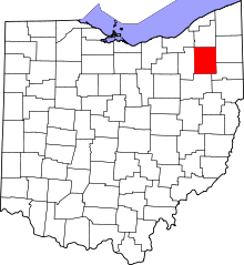 | |
| Villages | ||
| Townships | ||
| CDPs | ||
| Unincorporated communities | ||
| Former settlements | ||
| Footnotes | ‡This populated place also has portions in an adjacent county or counties | |