Hiram, Ohio
| Hiram, Ohio | |
|---|---|
| Village | |
|
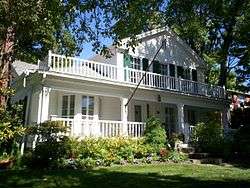
Former home of President James Garfield | |
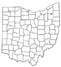 Location of Hiram, Ohio | |
 Location of Hiram in Portage County | |
| Coordinates: 41°18′37″N 81°8′46″W / 41.31028°N 81.14611°WCoordinates: 41°18′37″N 81°8′46″W / 41.31028°N 81.14611°W | |
| Country | United States |
| State | Ohio |
| County | Portage |
| Government | |
| • Mayor | Lou Bertrand[1] |
| Area[2] | |
| • Total | 0.93 sq mi (2.41 km2) |
| • Land | 0.93 sq mi (2.41 km2) |
| • Water | 0 sq mi (0 km2) |
| Elevation[3] | 1,253 ft (382 m) |
| Population (2010)[4] | |
| • Total | 1,406 |
| • Estimate (2012[5]) | 1,439 |
| • Density | 1,511.8/sq mi (583.7/km2) |
| Time zone | Eastern (EST) (UTC-5) |
| • Summer (DST) | EDT (UTC-4) |
| ZIP code | 44234 |
| Area code(s) | 330 |
| FIPS code | 39-35658[6] |
| GNIS feature ID | 1064842[3] |
| Website | http://www.hiramvillage.org/ |
Hiram is a village in Portage County, Ohio, United States. It was formed from portions of Hiram Township in the Connecticut Western Reserve. The population was 1,406 at the 2010 census. It is the location of Hiram College.
Hiram is part of the Akron Metropolitan Statistical Area.
Geography
Hiram is located at 41°18′37″N 81°8′46″W / 41.31028°N 81.14611°W (41.310255, -81.146145).[7]
According to the United States Census Bureau, the village has a total area of 0.93 square miles (2.41 km2), all land.[2]
Demographics
| Historical population | |||
|---|---|---|---|
| Census | Pop. | %± | |
| 1880 | 144 | — | |
| 1900 | 659 | — | |
| 1910 | 422 | −36.0% | |
| 1920 | 453 | 7.3% | |
| 1930 | 441 | −2.6% | |
| 1940 | 389 | −11.8% | |
| 1950 | 986 | 153.5% | |
| 1960 | 1,011 | 2.5% | |
| 1970 | 1,484 | 46.8% | |
| 1980 | 1,360 | −8.4% | |
| 1990 | 1,330 | −2.2% | |
| 2000 | 1,242 | −6.6% | |
| 2010 | 1,406 | 13.2% | |
| Est. 2015 | 1,263 | [8] | −10.2% |
2010 census
As of the census[4] of 2010, there were 1,406 people, 228 households, and 120 families residing in the village. The population density was 1,511.8 inhabitants per square mile (583.7/km2). There were 248 housing units at an average density of 266.7 per square mile (103.0/km2). The racial makeup of the village was 85.3% White, 8.2% African American, 0.4% Native American, 3.3% Asian, 0.6% from other races, and 2.1% from two or more races. Hispanic or Latino of any race were 2.1% of the population.
There were 228 households of which 25.4% had children under the age of 18 living with them, 38.6% were married couples living together, 8.3% had a female householder with no husband present, 5.7% had a male householder with no wife present, and 47.4% were non-families. 31.1% of all households were made up of individuals and 8.8% had someone living alone who was 65 years of age or older. The average household size was 2.35 and the average family size was 3.01.
The median age in the village was 21 years. 8.1% of residents were under the age of 18; 69.7% were between the ages of 18 and 24; 7.1% were from 25 to 44; 10.3% were from 45 to 64; and 4.8% were 65 years of age or older. The gender makeup of the village was 48.7% male and 51.3% female.
2000 census
As of the census[6] of 2000, there were 1,242 people, 234 households, and 147 families residing in the village. The population density was 1,367.2 people per square mile (527.0/km²). There were 249 housing units at an average density of 274.1 per square mile (105.6/km²). The racial makeup of the village was 91.22% White, 5.39% African American, 1.45% Asian, 0.40% from other races, and 1.53% from two or more races. Hispanic or Latino of any race were 1.61% of the population.
There were 234 households out of which 33.3% had children under the age of 18 living with them, 48.3% were married couples living together, 12.4% had a female householder with no husband present, and 36.8% were non-families. 28.2% of all households were made up of individuals and 3.8% had someone living alone who was 65 years of age or older. The average household size was 2.44 and the average family size was 3.04.
In the village the population was spread out with 13.0% under the age of 18, 58.5% from 18 to 24, 15.4% from 25 to 44, 9.4% from 45 to 64, and 3.7% who were 65 years of age or older. The median age was 21 years. For every 100 females there were 92.0 males. For every 100 females age 18 and over, there were 91.8 males.
The median income for a household in the village was $45,417, and the median income for a family was $50,139. Males had a median income of $36,932 versus $25,625 for females. The per capita income for the village was $17,734. About 1.4% of families and 4.3% of the population were below the poverty line, including 2.1% of those under age 18 and none of those age 65 or over.
People and places of note
Former U.S. President James A. Garfield resided in Hiram as a student, instructor, and principal at Western Reserve Eclectic Institute, now Hiram College. He married Lucretia Rudolph, who was a Hiram native. Several of their children were also born in Hiram, including Harry Augustus Garfield, former president of Williams College, and James Rudolph Garfield, who became the 23rd United States Secretary of the Interior under Theodore Roosevelt. Garfield's home is on Hinsdale Street in Hiram and is presently owned by Hiram College. Author Troy Taylor considers it to be haunted.[10]
Jack Trice was born in Hiram in 1902. He left Hiram to live with an uncle in 1918. On October 6, 1923, he was fatally injured while playing in a college football game at Iowa State University against the University of Minnesota. Trice died two days later. Iowa State's football stadium was renamed Jack Trice Stadium in his honor in 1997.[11]
Religious songwriter Jesse Brown Pounds lived in Hiram.[12]
References
- ↑ Jovich, Don (2008-01-18). "Hiram's new mayor stresses cooperation; Former councilman Bertrand takes office". Record-Courier. Kent and Ravenna, Ohio: Dix Communications. Retrieved 2008-01-27.
- 1 2 "US Gazetteer files 2010". United States Census Bureau. Retrieved 2013-01-06.
- 1 2 "US Board on Geographic Names". United States Geological Survey. 2007-10-25. Retrieved 2008-01-31.
- 1 2 "American FactFinder". United States Census Bureau. Retrieved 2013-01-06.
- ↑ "Population Estimates". United States Census Bureau. Retrieved 2013-06-17.
- 1 2 "American FactFinder". United States Census Bureau. Retrieved 2008-01-31.
- ↑ "US Gazetteer files: 2010, 2000, and 1990". United States Census Bureau. 2011-02-12. Retrieved 2011-04-23.
- ↑ "Annual Estimates of the Resident Population for Incorporated Places: April 1, 2010 to July 1, 2015". Retrieved July 2, 2016.
- ↑ "Census of Population and Housing". Census.gov. Retrieved June 4, 2015.
- ↑ Taylor, Troy (1998). "The Garfield House". Ghosts of the Prairie: History & Hauntings of Illinois and Beyond. Dark Haven Entertainment. Retrieved 2008-01-27.
- ↑ Jack Trice, Papers, 1923-[ongoing], RS 21/7/23, University Archives, Special Collections Department, Iowa State University Library. Retrieved from http://www.lib.iastate.edu/arch/rgrp/21-7-23.html on January 27, 2008.
- ↑ "Jesse H. Brown Pounds".
External links
| Wikimedia Commons has media related to Hiram, Ohio. |
Municipalities and communities of Portage County, Ohio, United States | ||
|---|---|---|
| Cities | 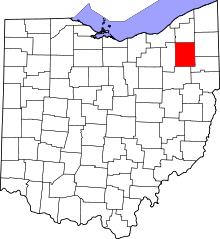 | |
| Villages | ||
| Townships | ||
| CDPs | ||
| Unincorporated communities | ||
| Former settlements | ||
| Footnotes | ‡This populated place also has portions in an adjacent county or counties | |