Streetsboro, Ohio
| Streetsboro, Ohio | ||
|---|---|---|
| City | ||
|
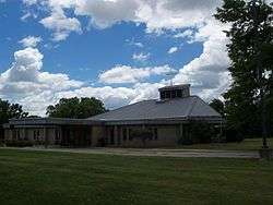
Saint Joan of Arc Church on Route 14 was built in 1987 | ||
| ||
| Motto: Gateway to Progress | ||
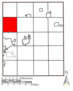 Location of Streetsboro in Portage County | ||
 Streetsboro, Ohio  Streetsboro, Ohio Location in the United States and Ohio | ||
| Coordinates: 41°14′33″N 81°20′57″W / 41.24250°N 81.34917°WCoordinates: 41°14′33″N 81°20′57″W / 41.24250°N 81.34917°W | ||
| Country | United States | |
| State | Ohio | |
| County | Portage | |
| Founded | 1822 | |
| Incorporated | 1968 | |
| Government | ||
| • Mayor | Glenn Broska | |
| Area[1] | ||
| • Total | 24.36 sq mi (63.09 km2) | |
| • Land | 23.46 sq mi (60.76 km2) | |
| • Water | 0.90 sq mi (2.33 km2) | |
| Elevation | 1,132 ft (345 m) | |
| Population (2010)[2] | ||
| • Total | 16,028 | |
| • Estimate (2014[3]) | 16,238 | |
| • Density | 683.2/sq mi (263.8/km2) | |
| Time zone | EST (UTC-5) | |
| • Summer (DST) | EDT (UTC-4) | |
| ZIP code | 44241 | |
| Area code(s) | 330, 234 | |
| FIPS code | 39-75014[4] | |
| GNIS feature ID | 1061212[5] | |
| Website |
cityofstreetsboro | |
Streetsboro is a city in Portage County, Ohio, United States. It is formed from the former township of Streetsboro, which was formed from the Connecticut Western Reserve. It is nearly co-extant with the former Streetsboro Township; the village of Sugar Bush Knolls was also formed in part from a small portion of the former township. The population was 12,311 at the 2000 census, and 16,028 at the 2010 census.[6] It is part of the Akron Metropolitan Statistical Area.
Geography
According to the United States Census Bureau, the city has a total area of 24.36 square miles (63.09 km2), of which 23.46 square miles (60.76 km2) is land and 0.90 square miles (2.33 km2) is water.[1]
History
Long before settlers moved into the Connecticut Western Reserve, Seneca Indians traversed the area now called Streetsboro. They used Old Portage Trail, which crosses the southwest corner of the city, to go from Lake Erie to the Ohio River basin.
The founder of Streetsboro Township was Titus Street from Connecticut, who purchased the land in 1798. Streetsboro Township contained 15,279 acres (61.83 km2). The land was surveyed by Streets' agents Ralph Cowles and Lemuel Punderson in the summer of 1822 and divided into lots of 100 acres (0.40 km2).
In 1825, a turnpike from Cleveland to Wellsville, Ohio was laid by Frederick Wadsworth, Samuel Cowles, John Strauyhen and Titus Street. Street agreed to give enough land to make it through the township. In 1827, the turnpike was completed. It followed much of the route of the present Ohio State Route 14.
Major growth occurred in Streetsboro with the opening of the Ohio Turnpike on October 1, 1955, with Exit 13 (now known as Exit 187) initially being the only interchange in Portage County. By 1957, with the growth of the automobile industry, Streetsboro experienced a population explosion. Proximity to the Akron and Cleveland areas, along with direct access to Interstate 80 (Ohio Turnpike), Interstate 480 and State Routes 303, 43 and 14, have greatly contributed to the rapid growth of manufacturing, distribution, commercial and residential development in the past fifty years.
In 1968, voters decided to merge the township and the village to become one city consisting of 25 square miles (65 km2). Streetsboro was primarily a farming community until 1970.
Streetsboro was home to a small amusement park, Shady Lake Park, located on Route 14, which is now an apartment complex of the same name.
Due to the steady growth of Streetsboro and its surrounding area within the past ten years, the city has become a retail hub for Portage County with the arrival of many national big-box retailers including Wal-Mart Supercenter, Target, Lowe's, The Home Depot and Staples. The first Northeast Ohio location for Sonic Drive-In opened in Streetsboro in September 2008.
Demographics
| Historical population | |||
|---|---|---|---|
| Census | Pop. | %± | |
| 1900 | 672 | — | |
| 1910 | 674 | 0.3% | |
| 1920 | 715 | 6.1% | |
| 1930 | 709 | −0.8% | |
| 1940 | 894 | 26.1% | |
| 1950 | 1,107 | 23.8% | |
| 1960 | 5,767 | 421.0% | |
| 1970 | 7,966 | 38.1% | |
| 1980 | 9,055 | 13.7% | |
| 1990 | 9,932 | 9.7% | |
| 2000 | 12,311 | 24.0% | |
| 2010 | 16,028 | 30.2% | |
| Est. 2015 | 16,312 | [7] | 1.8% |
| Sources:[8][9][10][11][4][3] | |||
2010 census
As of the census[2] of 2010, there were 16,028 people, 6,562 households, and 4,316 families residing in the city. The population density was 683.2 inhabitants per square mile (263.8/km2). There were 7,104 housing units at an average density of 302.8 per square mile (116.9/km2). The racial makeup of the city was 87.7% White, 7.9% African American, 0.2% Native American, 2.2% Asian, 0.3% from other races, and 1.8% from two or more races. Hispanic or Latino of any race were 1.7% of the population.
There were 6,562 households of which 31.4% had children under the age of 18 living with them, 50.3% were married couples living together, 11.1% had a female householder with no husband present, 4.4% had a male householder with no wife present, and 34.2% were non-families. 26.5% of all households were made up of individuals and 6.8% had someone living alone who was 65 years of age or older. The average household size was 2.43 and the average family size was 2.97.
The median age in the city was 37.9 years. 22.3% of residents were under the age of 18; 8.3% were between the ages of 18 and 24; 30.5% were from 25 to 44; 27% were from 45 to 64; and 11.7% were 65 years of age or older. The gender makeup of the city was 48.5% male and 51.5% female.
2000 census
As of the census[4] of 2000, there were 12,311 people, 4,908 households, and 3,381 families residing in the city. The population density was 512.6 people per square mile (197.9/km²). There were 5,244 housing units at an average density of 218.3 per square mile (84.3/km²). The racial makeup of the city was 95.39% White, 1.96% African American, 0.09% Native American, 1.37% Asian, 0.02% Pacific Islander, 0.15% from other races, and 1.02% from two or more races. Hispanic or Latino of any race were 0.78% of the population.
There were 4,908 households out of which 31.1% had children under the age of 18 living with them, 55.3% were married couples living together, 9.9% had a female householder with no husband present, and 31.1% were non-families. 25.1% of all households were made up of individuals and 5.7% had someone living alone who was 65 years of age or older. The average household size was 2.49 and the average family size was 3.00.
In the city the population was spread out with 24.3% under the age of 18, 8.3% from 18 to 24, 35.8% from 25 to 44, 21.8% from 45 to 64, and 9.8% who were 65 years of age or older. The median age was 34 years. For every 100 females there were 96.7 males. For every 100 females age 18 and over, there were 93.6 males.
The median income for a household in the city was $48,661, and the median income for a family was $55,814. Males had a median income of $36,672 versus $27,835 for females. The per capita income for the city was $21,764. About 3.9% of families and 5.3% of the population were below the poverty line, including 7.5% of those under age 18 and 6.1% of those age 65 or over.
 |
Twinsburg Township | Aurora | Mantua Township | |
| Hudson | |
Shalersville Township | ||
| ||||
| | ||||
| Stow | Franklin Township, The Village of Sugar Bush Knolls | Ravenna Township |
Education
Primary and secondary education is provided mainly by the Streetsboro City School District, which includes five schools, while a small portion of the city is part of the neighboring Kent City School District. Students in preschool through first grade attend Wait Primary School, with grades two and three at Campus Elementary School. Henry Defer Intermediate School houses students in grades four through six with grades seven and eight at Streetsboro Middle School. Streetsboro High School includes grades nine through 12. All schools and the district offices, with the exception of Wait Primary School, are located on a 116-acre (47 ha) central campus with the Streetsboro City Park. The campus also includes the Pierce Streetsboro Library, a branch of the Portage County District Library, which opened in 1988.[12][13][14]
Voters in the district approved a $38.7 million bond issue in 2013 to fund expansion and renovations of the district's facilities.[15] Included in the plans are a new building for Streetsboro High School along State Route 14, scheduled to open in late 2016, and an expansion and renovation of Campus Elementary to accommodate the grades currently housed at Wait Primary School. That project is also scheduled to open by late 2016. Additional plans include renovation of the current high school building to house Streetsboro Middle School, which will enable grade six to be moved to the middle school from Henry Defer Intermediate School. At the conclusion of the expansions and renovations, the current Streetsboro Middle School and Wait Primary School buildings will close.[16]
Media
Radio
- WSTB 88.9 FM (Streetsboro High School-Alternative Rock Monday through Saturday, Oldies on Sunday)
Print media
- Gateway News (Weekly newspaper serving Streetsboro, Mantua Village and Township, and Shalersville Township)
Notable people
- Matthew Hannan, professional wrestler
- Henry H. Wyatt, Wisconsin State Assemblyman
References
- 1 2 "US Gazetteer files 2010". United States Census Bureau. Retrieved 2013-01-06.
- 1 2 "American FactFinder". United States Census Bureau. Retrieved 2013-01-06.
- 1 2 "Incorporated Places and Minor Civil Divisions Datasets: Subcounty Population Estimates: April 1, 2010 to July 1, 2014". U.S. Census Bureau. Retrieved January 25, 2016.
- 1 2 3 "American FactFinder". United States Census Bureau. Retrieved 2008-01-31.
- ↑ "US Board on Geographic Names". United States Geological Survey. 2007-10-25. Retrieved 2008-01-31.
- ↑ "Table 4: Census 2010 Ohio village, city, county populations and demographics, Cleveland Plain Dealer, from Official 2010 U.S. Census Data". U.S. Census Bureau. Retrieved 2011-06-29.
- ↑ "Annual Estimates of the Resident Population for Incorporated Places: April 1, 2010 to July 1, 2015". Retrieved July 2, 2016.
- ↑ "Population: Ohio" (PDF). 1910 U.S. Census. U.S. Census Bureau. Retrieved 28 November 2013.
- ↑ "Population: Ohio" (PDF). 1930 US Census. U.S. Census Bureau. Retrieved 28 November 2013.
- ↑ "Number of Inhabitants: Ohio" (PDF). 18th Census of the United States. U.S. Census Bureau. Retrieved 22 November 2013.
- ↑ "Ohio: Population and Housing Unit Counts" (PDF). U.S. Census Bureau. Retrieved 22 November 2013.
- ↑ "Streetsboro City Park". Streetsboro Parks & Recreation. 2016. Retrieved January 25, 2016.
- ↑ "Our Schools". Streetsboro City School District. 2016. Retrieved January 25, 2016.
- ↑ "Pierce Streetsboro Library". Portage County District Library. 2016. Retrieved January 25, 2016.
- ↑ Gaetjens, Bob (November 6, 2013). "Streetsboro voters approve bond issue for new school facilities". Record-Courier. Retrieved January 25, 2016.
- ↑ "OFCC Building Project". Streetsboro City School District. 2016. Retrieved January 25, 2016.
External links
| Wikimedia Commons has media related to Streetsboro, Ohio. |
- City website
- City of Streetsboro Chamber of Commerce
- City of Streetsboro The Visitors and Convention Bureau
Municipalities and communities of Portage County, Ohio, United States | ||
|---|---|---|
| Cities | 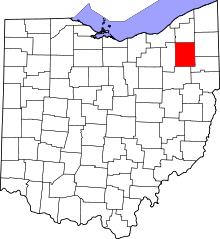 | |
| Villages | ||
| Townships | ||
| CDPs | ||
| Unincorporated communities | ||
| Former settlements | ||
| Footnotes | ‡This populated place also has portions in an adjacent county or counties | |