Shannon, County Clare
| Shannon Sionainn | |
|---|---|
| Town | |
|
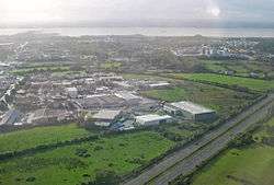
View over Shannon, with the industrial area on the left and the housing on the right. | |
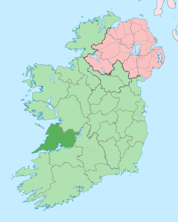
 Shannon Location in Ireland | |
| Coordinates: 52°42′49″N 8°52′07″W / 52.713731°N 8.868628°WCoordinates: 52°42′49″N 8°52′07″W / 52.713731°N 8.868628°W | |
| Country | Ireland |
| Province | Munster |
| County | County Clare |
| Dáil Éireann | Clare |
| EU Parliament | North-West |
| Elevation | 0 m (0 ft) |
| Population (2011) | |
| • Urban | 9,673 |
| Irish Grid Reference | R402624 |
| Website |
www |
| Historical population | ||
|---|---|---|
| Year | Pop. | ±% |
| 1841 | 241 | — |
| 1851 | 196 | −18.7% |
| 1861 | 156 | −20.4% |
| 1871 | 147 | −5.8% |
| 1881 | 95 | −35.4% |
| 1961 | 234 | +146.3% |
| 1966 | 1,658 | +608.5% |
| 1971 | 3,657 | +120.6% |
| 1981 | 7,998 | +118.7% |
| 1986 | 8,005 | +0.1% |
| 1991 | 7,920 | −1.1% |
| 1996 | 7,940 | +0.3% |
| 2002 | 8,561 | +7.8% |
| 2006 | 9,222 | +7.7% |
| 2011 | 9,673 | +4.9% |
| [1] | ||
Shannon (Irish: Sionainn) or Shannon Town (Baile na Sionnainne), named after the river near which it stands, is a town in County Clare, Ireland. It is a satellite town of the nearby city of Limerick, and was given town status on 1 January 1982. The town is located just off the N19 road, a spur of the N18/M18 road between Limerick and Ennis. It is the location of Shannon Airport, an international airport serving the Limerick/Clare region in the west of Ireland.
History
Shannon is a new town. Spearheaded by Brendan O'Regan,[2] it was built in the 1960s on reclaimed marshland alongside Shannon Airport, along with the Shannon Free Zone industrial estate.[3] The residential areas were intended as a home for the thousands of workers at the airport, surrounding industries and support services. Population growth was never as fast as planned throughout the first few decades of the town's existence. This was partly due to the proximity of 'friendly' places to live, such as Ennis town and Limerick city, or even the nearby village of Newmarket-on-Fergus.
The 'planned' nature of this town did not necessarily result in a successful town. It was lacking in facilities, and the town's shopping centre was also of poor design. Shops fronted onto pedestrian malls that were originally uncovered, allowing estuary winds and rain to strike at shoppers. The early low-cost housing (tower-block flats located in Drumgeely, near the airport) was poor-quality terraced housing.
Shannon was located in the parish of Newmarket-on-Fergus in the Roman Catholic Diocese of Killaloe, and at first a priest in residence of the airport served the population. In 1966 St. Senan’s School was opened and Mary Immaculate Church was built on Corrib Drive. On 24 December 1967 the parish of Shannon was created. For a short period a group of Dominican Sisters of England had a community in the parish. In 1974 they were replaced by the Sisters of Mercy. The church of Saints John and Paul was opened in Tullyvarraga in 1980.[4] Other churches are the Adoration Chapel in and the Shannon Airport Oratory.[5]
St. John’s Church of Ireland School was the very first school established in Shannon in 1962, Christ Church Shannon opened in 1962 also serving members of the reformed faiths, however it is closed at the present time, with the Church of Ireland community is served by the Drumcliffe Union and the Methodist community served by a lay pastor.
Recent developments
The population grew significantly in the 1990s, and new modern housing developments continued to be built. Facilities in the town are slowly improving; for example, a second major supermarket opened, with the shopping centre being expanded by the addition of the modern "Skycourt" complex.
The main road through Shannon was remodelled following the opening of the bypass of Newmarket-on-Fergus. New units continue to open in the industrial estates (despite some others closing or changing hands).
Education in Shannon
Shannon town currently has six primary schools, including a Gaelscoil (Gaelscoil Donncha Rua)[6] and a school under the patronage of Church of Ireland (St. Johns NS[7]).
There is two second level education institutes in the town, St. Patrick's Comprehensive School and St. Caimin's Community School. St. Patrick's Comprehensive School opened in 1966 as Ireland's first comprehensive school. It has been serving the town since and is due an extension to increase its capacity to over 900 pupils.
There is one third level institution in Shannon. The Shannon College of Hotel Management, which opened in 1951. Since 2015 it has been an official college of the National University of Ireland, Galway.
Economy
Shannon Free Zone is Ireland's largest cluster of North American investments. Since its establishment in 1959, more than 110 overseas companies have chosen to open subsidiaries in Shannon. Major companies in Shannon include global market leaders as Symantec, Avocent, Genworth Financial, Lufthansa Technik, Mentor Graphics, RSA Security, Molex, GE Capital, Ingersoll Rand, Intel and Digital River.[8] Aer Rianta International, a subsidiary of Dublin Airport Authority, has its head office on the grounds of Shannon Airport.[9] When Eirjet existed, its head office was located on the grounds of Shannon Airport.[10]
Local Government and Politics
| Party | Seats | Change |
|---|---|---|
| Fine Gael | 4 | +2 |
| Labour Party | 2 | = |
| Independent | 3 | -1 |
| Sinn Féin | 0 | - |
| Fianna Fáil | 0 | -2 |
The town is administered at a local level by Clare County Council,preceded by Shannon Town Council,which in turn succeeded the Shannon Town Commissioners.[11] In addition, prior to September 2004, Shannon Development, a state-sponsored body had charge of many services normally provided by local authorities in the Republic of Ireland. This gave Shannon a unique status in local governance. In September 2004 its situation was regularised when Shannon Development transferred its local government functions to Clare County Council.[12] The company retains responsibility for the Shannon Free Zone.
Climate
Climate in this area has mild differences between highs and lows, and there is adequate rainfall year round. The Köppen Climate Classification subtype for this climate is "Cfb" (Marine West Coast Climate/Oceanic climate).[13]
| Climate data for Shannon Airport, (1981–2010, extremes 1938–present) | |||||||||||||
|---|---|---|---|---|---|---|---|---|---|---|---|---|---|
| Month | Jan | Feb | Mar | Apr | May | Jun | Jul | Aug | Sep | Oct | Nov | Dec | Year |
| Record high °C (°F) | 14.8 (58.6) |
15.5 (59.9) |
20.2 (68.4) |
23.5 (74.3) |
27.2 (81) |
31.6 (88.9) |
30.6 (87.1) |
29.8 (85.6) |
26.1 (79) |
23.0 (73.4) |
18.2 (64.8) |
16.2 (61.2) |
31.6 (88.9) |
| Average high °C (°F) | 8.8 (47.8) |
9.2 (48.6) |
11.1 (52) |
13.3 (55.9) |
16.0 (60.8) |
18.3 (64.9) |
19.8 (67.6) |
19.6 (67.3) |
17.7 (63.9) |
14.3 (57.7) |
11.1 (52) |
9.0 (48.2) |
14.0 (57.2) |
| Daily mean °C (°F) | 6.0 (42.8) |
6.2 (43.2) |
7.8 (46) |
9.5 (49.1) |
12.1 (53.8) |
14.6 (58.3) |
16.4 (61.5) |
16.2 (61.2) |
14.2 (57.6) |
11.2 (52.2) |
8.3 (46.9) |
6.3 (43.3) |
10.7 (51.3) |
| Average low °C (°F) | 3.2 (37.8) |
3.2 (37.8) |
4.5 (40.1) |
5.7 (42.3) |
8.2 (46.8) |
10.9 (51.6) |
12.9 (55.2) |
12.7 (54.9) |
10.8 (51.4) |
8.2 (46.8) |
5.5 (41.9) |
3.6 (38.5) |
7.4 (45.3) |
| Record low °C (°F) | −11.9 (10.6) |
−9.8 (14.4) |
−7.8 (18) |
−4.6 (23.7) |
−1.7 (28.9) |
0.9 (33.6) |
4.4 (39.9) |
2.8 (37) |
−0.6 (30.9) |
−3.3 (26.1) |
−7.2 (19) |
−11.4 (11.5) |
−11.9 (10.6) |
| Average precipitation mm (inches) | 102.3 (4.028) |
76.2 (3) |
78.7 (3.098) |
59.2 (2.331) |
64.8 (2.551) |
69.8 (2.748) |
65.9 (2.594) |
82.0 (3.228) |
75.6 (2.976) |
104.9 (4.13) |
94.1 (3.705) |
104.0 (4.094) |
977.6 (38.488) |
| Average precipitation days (≥ 0.2 mm) | 20 | 16 | 19 | 16 | 16 | 15 | 16 | 18 | 16 | 20 | 20 | 19 | 211 |
| Average snowy days | 2.3 | 2.3 | 1.4 | 0.5 | 0.0 | 0.0 | 0.0 | 0.0 | 0.0 | 0.0 | 0.1 | 1.3 | 8.0 |
| Average relative humidity (%) | 80.5 | 74.6 | 70.5 | 64.4 | 63.3 | 65.1 | 68.0 | 68.2 | 69.2 | 75.2 | 80.5 | 83.1 | 71.9 |
| Mean monthly sunshine hours | 49.6 | 65.0 | 99.2 | 153.0 | 179.8 | 156.0 | 139.5 | 139.5 | 117.0 | 89.9 | 60.0 | 43.4 | 1,291.9 |
| Mean daily sunshine hours | 1.6 | 2.3 | 3.2 | 5.1 | 5.8 | 5.2 | 4.5 | 4.5 | 3.9 | 2.9 | 2.0 | 1.4 | 3.5 |
| Source: Met Éireann[14][15][16] | |||||||||||||
Twin towns – Sister cities
Shannon is twinned with:
 Guingamp, France
See also
References
- ↑ Central Statistics Office Ireland and Histpop - The Online Historical Population Reports Website. Shannon was not a census form until 1961. Pre 1961 figures include the townlands of Clenagh, Drumline and Rineanna. Post 1996 figures include the environs of Shannon Clenagh.
- ↑ "Tributes paid to Clare man who pioneered duty free at Shannon". Irish Times. 4 February 2008.
- ↑ "Our Town," www.shannon.ie
- ↑ "Shannon". Diocese of Killaloe. Retrieved 2014-04-01.
- ↑ "Shannon Churches". Diocese of Killaloe. Retrieved 2014-04-01.
- ↑ "Gaelscoil Donncha Rua, Shannon, Co. Clare". www.gdr.ie. Retrieved 2016-06-09.
- ↑ "St. John's National School, Shannon". www.stjohnsns.org. Retrieved 2016-06-09.
- ↑ An Economic Overview of Ireland’s Shannon Region February 2012, p. 14]
- ↑ "Contact Us." Aer Rianta International. Retrieved on 7 July 2010.
- ↑ "home." Eirjet. 1 July 2006. Retrieved on 15 September 2010.
- ↑ Shannon Town Council Origins
- ↑
- ↑ Climate Summary for Shannon
- ↑ "Shannon Airport 1981–2010 averages". Met Éireann. Retrieved 13 October 2016.
- ↑ "Absolute Maximum Air Temperatures for each Month at Selected Stations" (PDF). Met Éireann. Retrieved 13 October 2016.
- ↑ "Absolute Minimum Air Temperatures for each Month at Selected Stations" (PDF). Met Éireann. Retrieved 13 October 2016.
External links
| Wikimedia Commons has media related to Shannon, County Clare. |

