Spancill Hill, County Clare
| Spancill Hill | |
|---|---|
| Settlement | |
 Spancill Hill Location in Ireland | |
| Coordinates: 52°52′16″N 8°54′01″W / 52.871033°N 8.900156°WCoordinates: 52°52′16″N 8°54′01″W / 52.871033°N 8.900156°W | |
| Country |
|
| Province | Munster |
| County | County Clare |
| Municipal district | Ennis[1] |
| Electoral division | Spancelhill |
| Townland | Muckinish |
| Time zone | WET (UTC+0) |
| • Summer (DST) | IST (WEST) (UTC-1) |
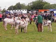
Spancill Hill or Spancilhill (Ordnance Survey spelling Spancel Hill for the hill[2] and settlement,[3] Spancelhill for the electoral division;[4][2] Irish: Cnoc Uarchoille[2]) is a hill and adjacent dispersed settlement in County Clare, Ireland. The historic hamlet of Spancilhill was by the fair green,[5] which is still the site of the Spancill Hill Fair, Ireland's oldest horse fair, which occurs annually on 23 June.[6] Houses are concentrated slightly south at Cross of Spancilhill, where the R352 road between Ennis to the west and Tulla to the east crosses a local road between Barefield to the north and Quin to the south.[7]
Name
The original Irish name was Cnoc Fhuar Choille ["Cold Wood Hill"], which was misinterpreted as Cnoc Urchaill ["Spancel Hill"].[3][8] A spancel is a rope used to tie an animal's legs together; the association of the place with a horse fair encouraged the misinterpretation. The hill itself was called Knockrughil on the 1842 six-inch Ordnance Survey map and 1896 25-inch map.[5]
History
Spancel Hill is in the townland of Muckinish, civil parish of Clooney, and barony of Bunratty Upper.[2] The fair had a royal charter from Charles II of England.[9] Historically, fairs were held on 1 January, 3 May, 24 June, 20 August, and 3 December.[10] In 1913, British and Continental cavalry forces bought over 1,000 horses there.[9]
In 1841 the population of the village was 169, in 26 houses.[11] In 1851, after the Great Famine, there were fewer than 20 houses, so its population was not recorded separately from the townland, whose total population had fallen from 278 in 46 houses to 174 in 34.[12] In 1911 the townland population was 72, in 14 houses.[13]
See also
- "Spancil Hill", a song written in a traditional Irish folk style by Michael Considine, a local who emigrated to America.
References
- ↑ "S.I. No. 42/2014 - County of Clare Local Electoral Areas and Municipal Districts Order 2014.". Irish Statute Book. Retrieved 19 May 2015.
- 1 2 3 4 "Cnoc Uarchoille/Spancel Hill". Placenames Database of Ireland. Retrieved 19 May 2015.
- 1 2 "Cnoc Uarchoille/Spancel Hill". Placenames Database of Ireland. Retrieved 19 May 2015.
- ↑ "Cnoc Uarchoille/Spancelhill". Placenames Database of Ireland. Retrieved 19 May 2015.
- 1 2 "25-inch map centred on Knockrughil". Mapviewer. Ordnance Survey Ireland. 1896. Retrieved 8 June 2015.
- ↑ "Spancill Hill Fair Today". Clare FM. 23 June 2009. Retrieved 19 May 2015.
- ↑ O'Flynn, David (2011). Horse: The Horse and Irish Society. The History Press Ireland. p. 37. ISBN 9781845887063. Retrieved 19 May 2015.
- ↑ Ó Dónaill, Niall (1977). "urchall". Foclóir Gaeilge–Béarla. Retrieved 19 May 2015.
- 1 2 "History". Spancilhill Fair. Spancilhill Show and Fair Association. Retrieved 14 June 2011.
- ↑ Lewis, Samuel (1837). "Cloney". A Topographical Dictionary of Ireland. Retrieved 19 May 2015.
- ↑ "Clare Places: Spancel-Hill". Parliamentary Gazeteer of Ireland. 1845. Retrieved 19 May 2015.
- ↑ "County of Clare, Barony of Bunratty Upper, Parish of Clooney". Census of Ireland 1851. 1852. pp. 8, fn.f. Retrieved 19 May 2015.
- ↑ "Muckinish townland, Spancelhill DED". Census of Ireland 1911. National Archives of Ireland. Retrieved 19 May 2015.
External links
- Spancel Hill Clare County Library website
Places in County Clare | ||
|---|---|---|
| Towns | 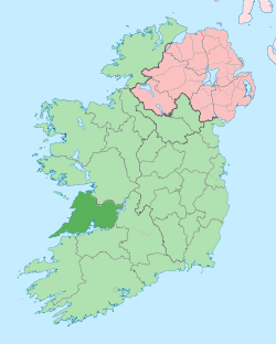 | |
| Villages |
| |
| Regions | ||
| Islands | ||
| ||