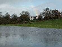
Shelderton
| Shelderton | |
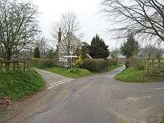 Finger signpost in Shelderton — lanes lead to Clungunford, Leintwardine and Onibury |
|
 Shelderton |
|
| OS grid reference | SO405777 |
|---|---|
| Civil parish | Clungunford |
| Unitary authority | Shropshire |
| Ceremonial county | Shropshire |
| Region | West Midlands |
| Country | England |
| Sovereign state | United Kingdom |
| Post town | CRAVEN ARMS |
| Postcode district | SY7 |
| Dialling code | 01547 |
| Police | West Mercia |
| Fire | Shropshire |
| Ambulance | West Midlands |
| EU Parliament | West Midlands |
| UK Parliament | Ludlow |
|
|
Coordinates: 52°23′38″N 2°52′26″W / 52.394°N 2.874°W
Shelderton is a hamlet in south Shropshire, England. It is located just southeast of the village of Clungunford and is part of that village's civil parish.[1]
It was a medieval township[2] and belonged to Munslow hundred.[3]
The border with Herefordshire is nearby to the south. The small hamlet of Little Common is near to Shelderton, on the B4367 road, and is connected with Shelderton by a footpath (grid reference SO398776). Also on the B4367, near to where the Leintwardine lane from Shelderton meets the B4367, is a Grade II Listed house called The Lynches (grid reference SO396769).[1][4]
The nearest market towns are Craven Arms and Ludlow.
A Roman road runs through Shelderton, on its way between the Roman fort and settlement at Leintwardine and the city at Wroxeter.
There is a Royal Mail post box in the hamlet.[5]
References
- 1 2 Ordnance Survey mapping
- ↑ GENUKI The National Gazetteer of Great Britain and Ireland (1868)
- ↑ GENUKI Shropshire hundreds
- ↑ British Listed Buildings The Lynches, Clungunford
- ↑ dracos.co.uk Postboxes in SY7
External links
![]() Media related to Shelderton at Wikimedia Commons
Media related to Shelderton at Wikimedia Commons
| Unitary authorities | |
|---|---|
| Major settlements | |
| Rivers | |
| Canals | |
| Topics | |