Shire of Belyando
| Shire of Belyando Queensland | |||||||||||||
|---|---|---|---|---|---|---|---|---|---|---|---|---|---|
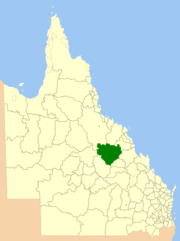 Location within Queensland | |||||||||||||
| Population | 10,455 (2006 census)[1] | ||||||||||||
| • Density | 0.345263/km2 (0.89423/sq mi) | ||||||||||||
| Established | 1879 | ||||||||||||
| Area | 30,281.3 km2 (11,691.7 sq mi) | ||||||||||||
| Council seat | Clermont | ||||||||||||
| Region | Central Queensland | ||||||||||||
|
| |||||||||||||
| |||||||||||||
The Shire of Belyando was a local government area in Central Queensland, Australia. The Shire, administered from the town of Clermont, covered an area of 30,281.3 square kilometres (11,691.7 sq mi), and existed as a local government entity from 1879 until 2008, when it was amalgamated with the Shires of Broadsound and Nebo to form the Isaac Region.
The shire had two main towns, Clermont and Moranbah, and its economy was based on agriculture and mining. There are two coal mines in the area, one owned by BMA and one by Anglo Coal serviced by the town of Moranbah.
It is pronounced Bel-yando.[2]
History
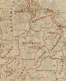
On 11 November 1879, the Belyando Division was established as one of 74 divisions around Queensland under the Divisional Boards Act 1879 with a population of 1494.[3]
On 20 September 1884, Peak Downs Division was separated from the southern part of Belyando Division.
With the passage of the Local Authorities Act 1902, Belyando Division became Shire of Belyando on 31 March 1903.
On 15 March 2008, under the Local Government (Reform Implementation) Act 2007 passed by the Parliament of Queensland on 10 August 2007, Belyando merged with the Shires of Broadsound and Nebo to form the Isaac Region.[4]
Towns and localities
The Shire of Belyando included the following settlements:
Chairmen
- 1927: Anthony William Appleton [5]
Population
| Year | Population |
|---|---|
| 1933 | 2,987 |
| 1947 | 3,067 |
| 1954 | 3,104 |
| 1961 | 3,253 |
| 1966 | 2,997 |
| 1971 | 4,834 |
| 1976 | 7,210 |
| 1981 | 7,700 |
| 1986 | 11,362 |
| 1991 | 11,082 |
| 1996 | 10,755 |
| 2001 | 9,883 |
| 2006 | 10,455 |
References
- ↑ Australian Bureau of Statistics (25 October 2007). "Belyando (S) (Local Government Area)". 2006 Census QuickStats. Retrieved 3 June 2013.
- ↑ "The history of names: Mackay district". www.abc.net.au. Retrieved 2016-01-01.
- ↑ "Proclamation [Belyando Division]". Queensland Government Gazette. 11 November 1879. p. 25:1005.
- ↑ "Agency ID11032, Isaac Regional Council". Queensland State Archives. Retrieved 24 September 2013.
- ↑ Pugh, Theophilus Parsons (1927). Pugh's Almanac for 1927. Retrieved 13 June 2014.
External links
Coordinates: 22°24′36.97″S 147°52′41.85″E / 22.4102694°S 147.8782917°E